Rendercontrol
Jump to navigation
Jump to search
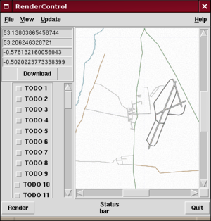
![]()

Rendering Waddington
Rendercontrol is a Perl/TK graphical user interface to Osmarender
Running the program
http://svn.openstreetmap.org/utils/rendercontrol/rendercontrol.pl
You will need:
- Perl itself
- perl-tk
- LWP (for downloading files from the web)
- Some command-line programs listed below, to do the actual work (inkscape, xmlstarlet, imagemagick)
Usage
Run the program
perl rendercontrol.pl
Initialisation stage
The program will ask a series of questions, and use your answers to create a configuration file. You can just press Enter instead of answering, then edit the config file later if you prefer.
- whether it has permission to connect to the net (at the moment, it will exit if you don't type Y, yes, or similar)
- OpenStreetMap username and password (used to download OSM data)
- Location of certain files (it will look for these in some common locations, or ask you for a filename if it can't find them)
- Inkscape
- XmlStarlet
- ImageMagick
- JOSM bookmarks file
Once questions are answered, it will download the latest copy of osmarender from the OpenStreetMap SVN site
Basic usage
- Use the File/Bookmarks menu to select a location (by default this is downloaded from OJW/Bookmarks, but you can copy your JOSM bookmark file here).
- Alternatively, type the coordinates into edit boxes (S,N,W,E in degrees)
- Press download button. If you have a valid OSM password, it will download the area and store it as data.osm
- Press render button. If you have xmlstarlet, inkscape, and ImageMagick installed, it will
- render data.osm into output.svg
- rasterise output.svg into output.png
- convert output.png into output.jpg and output.gif (GIF format is required for the TK image control)
- display the rendered output.gif in the main window
Projects
- Save project creates a sub directory and stores all your working files (data.osm output.svg, etc.) in there
- Load project copies a set of files from a project directory into the working area
That means you can work on renders of several areas without having to download new data each time.
Other features
- View menu lets you look at the various files in use
- OSM data - displays raw OSM XML data
- Osmarender - displays osmarender source code
- SVG - displays SVG source code of the rendered map
- Image - displays the output image
- Update menu
- Download from web downloads the latest version of osmarender
- Reload options reloads the rendercontrol's options file
Future work
- GUI improvements
- Graphical editor for rendering rules (e.g. road colours, visibility) - that's when the TODO buttons in the screenshot will become style editor widgets
- Support for more types of tools (e.g. other XSLT tools, other SVG renderers, other OSM rendering tools)
- Ability to edit the various textfiles from within the GUI (like an OSM IDE)
- More TLA's in the OSM XML GUI IDE SVN documentation ;)
Other ideas
- How about making a "render this area" menu in JOSM?
- Can we make the shared bookmarks file better (e.g. organise it by area, add everyone else's JOSM bookmarks)
Links
- OJW/Bookmarks - example bookmarks file
- Feel free to add proper bookmarks to this page
- Put this page on your watchlist, as changes to it will affect anyone who uses rendercontrol
- Revision history
- Programs