St Albans
Jump to navigation
Jump to search
| V・T・E |
| latitude: 51.750, longitude: -0.3333 |
| Browse map of St Albans 51°45′00.00″ N, 0°19′59.88″ W |
| Edit map |

|
|
External links:
|
| Use this template for your locality |
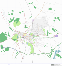
St Albans is a city in Hertfordshire at latitude 51°45′00.00″ North, longitude 0°19′59.88″ West.
I have just moved to St Albans and am starting to map it. TomChance 18:37, 1 October 2006 (BST)
Rough guide to coverage:
- Bernard's Heath: 5%
- City centre: 70% (Everything in between Folly/Catherine/Hatfield/London/High/Veralum roads done)
- Fleetville: 95% (Schools need doing)
- London Colney: 5%
- Marshalswick: 15% (South West Corner bordered by Marshalswick Land done, except Heath Close)
- Park Street: 5%
- St Julians: 5%
- The Camp: 5%
- Townsend: 5%
- Tyttenhanger: 15%
See also WikiProject_Hertfordshire_England