Statistics Canada (StatsCAN)
Statistics Canada (StatsCAN) is the National Statistics Collection agency for Canada. Among other things, GIS data is collected. There is some data (charts/tables/GIS data) which is free, and others which cost $. Out of the free data, we are interested in 2 datasets. Boundary data, which lists the administrative areas (cities/regions/metro areas etc) and road names. You can see the directory list here http://www12.statcan.ca/census-recensement/2006/geo/index-eng.cfm
Boundary Data
Summary
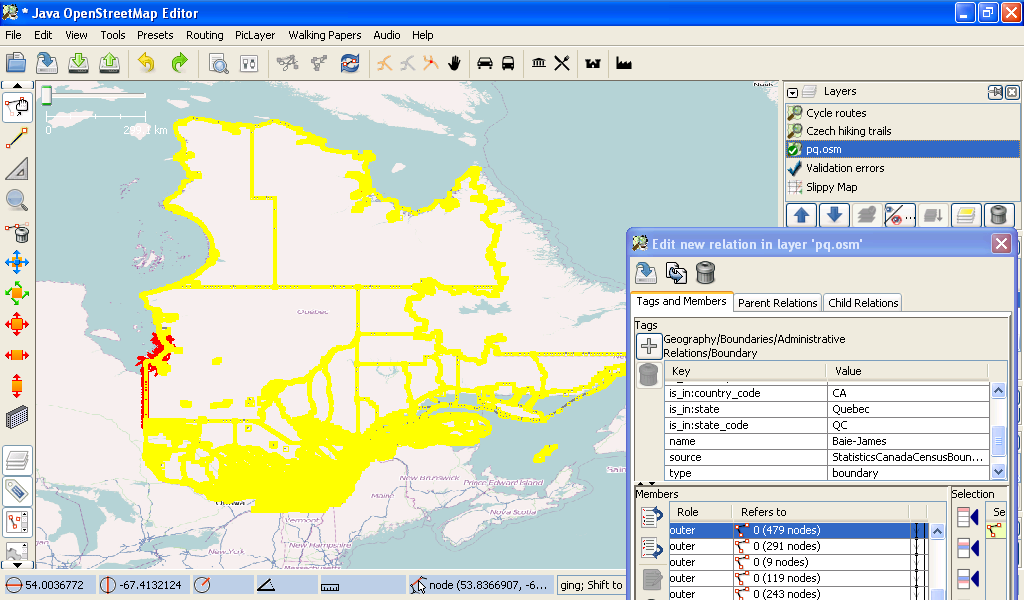
The boundary data is available as a complete Natonal shp file. User Tygunn has converted the data into Province sized. OSM files. The conversion script used was a modified version of ogr2osm used to create the converted boundaries; it is available at: ogr2osm_boundaries.zip. This method ensured that all of the relations where kept, essentially into 1 giant 'web' of relations.
Other boundary data
Other users have done some tracing from CanTopo GeoTIFFs, (for the Vancouver area) and have given permisison to overright the area with this better data. User:Acrosscanadatrails has also given permission to overight the GeoBase Aboriginal Lands data, as it was found that the conversion process used, did not account for the projection, resulting in a incorrect conversion.
Method
The method needs to be discussed with the talk-ca@ list. here's the draft idea: Using the mapnik wms overlay, and using the converted statscan.osm files, the community goes over all of the country and sees where existing boundary data exists. And removes the existing boundary data (which will cause conflict)
After the community is happy with the tags used & all of the existing boundary data is removed, then the import of it can happen all at once, by 1 user.
Tagging
Here's the list of tags that are shown in the converted .osm files.
Admin_level=* is not listed, as local area mappers would know the levels. the rest ... tba
Source / attribution
User:Acrosscanadatrails has contacted Statscan directed, and got an official responce.
On 6/25/10, Margaret.C**@stat**.gc.ca
- Hide quoted text -
<Margaret.C****@stat***.gc.ca> wrote:
> Hello Sam Vekemans,
>
> Thank you for contacting us to seek clarification on the licence agreement
> for the 2010 Census Subdivision Boundary File.  Please note that the
> Unrestricted Use agreement is the appropriate licence for this product.
> Therefore the use of this product goes beyond "personal use" as noted in the
> Unrestricted Use agreement.
>
>  The PDF statement that you mention is related to the Geography Catalogue of
> products and Services as well as the User Guide.  These are simply
> information products. We do understand how this could confuse a user.  We
> will see how best we can resolve this in order to avoid any confusion.
>
> Please do not hesitate to contact me for further information.
>
> Regards,
>
> Margaret Clement
> Manager, Pricing and Licensing / Gestionnaire, Tarification & octroi de
> licenses
...
> Statistics Canada | 100 Tunney's Pasture Driveway Ottawa ON K1A 0T6
> Statistique Canada | 100, promenade Tunney's Pasture Ottawa ON K1A 0T6
> Government of Canada | Gouvernement du Canada
>
The full archive message can be seen here. http://lists.openstreetmap.org/pipermail/talk-ca/2010-June/002931.html
TBA -
- list talk-ca permission notice
-lest description of Administrative Boundaries
The source of the data as a .zip file can be found here http://geodepot.statcan.gc.ca/2006/040120011618150421032019/0415231412150104_031904_05-eng.jsp?Submit=Download&Agreed=I+AGREE&year=y2010&language=E&format=A&fileType=DBF&geo=none&fileName=%2F2006%2F2009070518030114%2F01180309140615%2F040206%2F1401200915140112%2F031904-190418%2Fgcsd000a10a_e.zip
Or using the HTML selection form: http://geodepot.statcan.gc.ca/2006/040120011618150421032019/031904_05-eng.jsp
-list attribution -list tags used
-the admin_level is not set as this needs to be done my local area mappers who know the area mappers who know the area best
The statistics canada boundary files are being converted by user tygunn. If there's an area you're interested in, let him know.
- For a list of the CSDTYPE values that are being used to determine the place type, see: here
Converted Data
The following boundaries files have been converted:
- Boundaries for BC
- Boundaries for AB
- Boundaries for SK
- Boundaries for MB
- Boundaries for ON
- Boundaries for NB
- Boundaries for NS
- Boundaries for PEI
- Boundaries for PQ Quebec, 5.73 MB zipped, 37,3MB in OSM Format. (around 304962 objects to upload)
- Boundaries for NL
OSM Import Errors:
- There could be ways with more than 2000 nodes. You can fix them in Josm with a search query nodes:2000-10000 and split the ways with "P".
- There is no MRC metadata (group of municipality) in the OSM import. The data are available in the original files.
Road Names
Introduction (roads)
Statistics Canada maintains a road network data set for all of Canada. This data includes road names, and addressing information. Sounds wonderful, right? The downfall is that the geometry of the road data does NOT match the real world exactly.
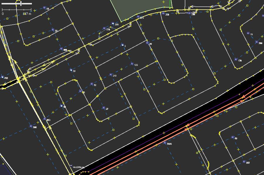
The dashed lines represent the Statistics Canada road network data imported into JOSM. Not only do the locations of roads not line up, but the shape/geometry of the roads don't match either. Further, the NRN data is somewhat low resolution and simplifies curvy roads and details like small bays.
Given the inherent inaccuracy of this data from a spatial perspective one would ask, "What is this even good for?". The BIG win with the Statistic Canada NRN data is that it includes address information, as well as road names. The GeoBase data for provinces such as Manitoba does not include address and street name data, so the NRN data becomes an invaluable resource.
Where to get it
If you are interested in getting a copy of the Statistics Canada Road Network data, you can get it from here. For the format choose "ARC/INFO (.shp)". The results of your efforts will be the data in SHAPE file format. If you'd like to read the shape file, download OpenJump, a free Java-based GIS editor.
2022-Sep-28 -- Road network files (RNF) now appear to be here: Document 92-500-X The information comes from [appears to be stored in] the National Geographic Database (NGD). There is an online ArcGIS viewer (of this specific data?) available here: ArcGIS. To avoid license issues only use downloaded data for mapping until the ArcGIS data is confirmed to not be contaminated with data from other sources. It might be time to re-confirm that the open license for this data has not changed.
NRN Data Format
The NRN data is provided in ESRI shape files (.shp). There are a number of fields defined in the source data; StatsCan has a pretty decent reference guide here. The most interesting part is the technical specifications section, which describes the various fields in the data.
The data is structured into a number of line segments, each potentially representing a range of addresses along a road. Each line segment has a number of attributes. The attributes that you'll be interested are as follows:
- RB_UID - The "ID" of the line segment; this is important to retain if we ever want to reference back to the NRN data source from the OSM data.
- NAME - The name of the road the segment represents (without the Avenue, Street part, and without any deference to directionality (ie South, South-West, etc).
- TYPE - The type of road the segment represents. See the street type section of the reference guide for more information on what values are applicable here. Basically this is an abbreviated version of the street type. So AVE would mean Avenue. In OSM-land we typically want to deal with the long names for these types.
- DIRECTION - The direction of the road. Again this is abbreviated, so the statcan reference is invaluable.
- ADDR_FM_LE - This is where it starts to get fun. ADDR_FM_LE represents the house number found to the LEFT of the road at the START of the line segment. If you look at the road network data in OpenJump its not going to be entirely clear where the start and end of each line segment is, so what side of the road the data refers to is going to be difficult to ascertain. Once the data is converted to OSM format, it'll be immediately clear when you click on the segment as OSM draws direction arrows on ways that point to the END of the way.
- ADDR_FM_RE - The house number found to the RIGHT of the road at the START of the line segment.
- ADDR_TO_LE - The house number found to the LEFT of the road at the END of the line segment.
- ADDR_TO_RE - The house number found to the RIGHT of the road at the END of the line segment.
Converting to OSM Address Interpolation Ways
I'll provide info on my Python scripts to import the shape files and create OSM address interpolation ways, as well as information on how you should fit these ways to the OSM data.
Generating OSM files with Street Names
I have also created a conversion script that transforms the NRN data into an OSM file, where each way has ONLY the following attributes: name - The street name name:source - Attribution for stats can name:statcan_rbuid - An ID within the NRN dataset that helps to identify the NRN road. Useful if in the future we want to look at new NRN data and check if existing roads have changed name.
To use this data:
- open up the OSM file in JOSM.
- download the area you're working on as a new layer.
- when you find an unnamed road, switch to the street names data layer.
- select the road where OSM is missing the name information.
- select COPY (or press CTRL-C).
- switch back to the OSM map layer.
- select the road you want to name and choose Edit-Paste Tags (CTRL-SHIFT_V).
- notice your street is now named.
I will convert over road names for any province on demand; just drop me a line (tygunn). So far I've got:
Uses of this data
If you're using this data, please feel free to add your current use of it to the list below:
- Tygunn is currently generating address interpolation ways for the City of Winnipeg and also filling in missing street names. In some instances looking at the NRN data has revealed roads that are missing in the OSM data.
- Ingalls is using the data to fill in missing road names in Saint John, NB
Maintainer
For more information, contact user Tygunn.

