TIGER fixup/250 cities/routing grid
This routing grid analysis was the first step in the TIGER fixup/250 cities project. We moved on to various other types of analysis (See TIGER fixup/250 cities)
The problem
TIGER data isn't routable, so at first there were no routes between US cities within OpenStreetMap. This gradually improved as the years went by, and in some areas routing works reasonably well (notably up and down the West Coast). However, Gravitystorm noticed in spring 2009 that there was no way to get from San Francisco to New York and set out to fix the entire route of the I-80. With that done, attention shifted to the I-70. With this nearing completion a good swathe of the US is interconnected, but there's still much more to be done. However, since it can now be broken down into practical chunks, it's more suitable to other people helping out.
The process
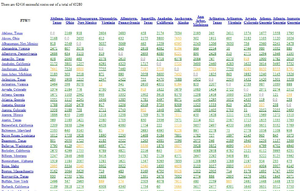
We take the biggest 250 cities in the US, and using CloudMade's routing engine generate pairs between them. This info is then munged into a giant 17Mb HTML table with links off to the routes and cities so that you can inspect them. It was originally re-generated each week.
How you can help

Have a look at the grid here:
http://matt.sandbox.cloudmade.com/usa-routes.html
(no longer updated)
Click on one of the yellow links. These are "tortuous" routes meaning they're at least 50% longer than the straight line distance between the cities. The link will take you to maps.cloudmade.com with the start and end locations. Have a look at the map, and figure out roughly which Interstates you would use to drive that route. So now we have a target route that needs fixing. Have a look at the start of your target route, and see which is the first city along the way. Drag the B marker to that city and see if you can route more directly from A to B. If you can, move B further along your target route to the next city, and keep doing that until you find the route takes a long detour. This indicates a break in the highway data.
Now you have a link between two cities that you know doesn't work. That's your target - to fix that link. Generally it'll take a fair amount of work to complete it - probably a few hours. You need to figure out which bits are broken, and dive on into an editor to have a good look at the data. Use the Yahoo! imagery to get it right, and take your time to do a proper job of things. When you get those two cities linked, move along to the next yellow link. Check back on the Grid each week and you'll see more things lit up in green.
Maps
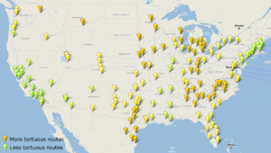
The routability map is all green now (can route between all cities)
The tortuous routes map shows yellow connections. It shows which of the connections look suspiciously long ( >1.5 times the great circle distance). It's a crude fuzzy indication, but reveals some interesting patterns.
Other maps are linked off TIGER fixup/250 cities
Progress
| Date | Successful routes | Total routes | Percentage OK |
|---|---|---|---|
| 2009-07-08 | 26636 | 65792 | 40.49% |
| 2009-07-15 | 26996 | 65792 | 41.03% |
| 2009-07-22 | 45883 | 65792 | 69.74% |
| 2009-07-28 | 60270 | 65792 | 91.61% |
| 2009-08-12 | 65295 | 65792 | 99.24% |
All cities except Honolulu are connected.
Phase 2 - discounting tortuous routes. Again aiming for 60,000 successful routes.
| Date | Successful routes | Total routes | Percentage OK |
|---|---|---|---|
| 2009-08-05 | 44941 | 65792 | 68.31% |
| 2009-08-12 | 52171 | 65792 | 79.30% |
| 2009-08-19 | 56427 | 65280 | 86.44% |
| 2009-08-26 | 60013 | 65280 | 91.93% |
| 2009-09-09 | 62416 | 65280 | 95.61% |
| 2009-09-23 | 63270 | 65280 | 96.92% |
| 2009-10-14 | 63831 | 65280 | 97.78% |
| 2009-11-04 | 63466 | 65280 | 97.22% |
| 2009-11-11 | 63438 | 65280 | 97.18% |
The CloudMade London team was in change of this. We haven't done an update in a while.
