Tag:leisure=park
 |
| Description |
|---|
| A park, usually in an urban (municipal) setting, created for recreation and relaxation. |
| Rendering in OSM Carto |

|
| Group: leisure |
| Used on these elements |
| Useful combination |
| Status: de facto |
| Tools for this tag |
|


A park is an area of open space for recreational use, usually designed and in semi-natural state with grassy areas, trees and bushes. Parks are usually urban, but not always; there are some rural parks[1]. Parks are smaller than their hosting city or town, being fully contained within them. Even though parks are typically open to the public, they can be fenced off, temporarily closed (like at night time) or open only to certain people (e.g. homeowners, residents).
This tag is intended for (usually urban) parks with managed greenery, located within settlements and nearly always open to general public. Such an area may be known also as metropolitan park, municipal park (North America) or public park, public open space, or municipal gardens (UK)[2]. They are largely a "human-sculpted landscape." Note that there are also areas called "national parks," "landscape parks," or similar that may be shortened to "park." Such large, national-level (and state- and provincial-level in North America) parks not so designed and manicured, but rather left in a more wild and natural state should not get this tag, instead, use another tag like boundary=national_park; see below.
Additionally, consider a "landuse=greenery" tag for green areas that have grass or trees on the land left over from a specific use.
How to map
Draw as an area along the park's outline and tag it with leisure=park and name=*. In cases where it is currently unfeasible to map a park as an area it is possible to map it as a node and later map it as an area.
Ways (highway=path or highway=footway) leading into a park from a road, should always be connected to the road for routing purposes. It's debatable whether they should connect to the park area with a shared node, or cross over the polygon without connecting.
Lakes and forests in a park belong to it, so don't use separate multipolygon elements to exclude them! Note: there may be exceptions to this in some parks, where because of the complexities of local water law or "inholdings" (areas "in" a park which are excluded because of private ownership), a lake or pond might actually be correctly excluded.
Tags used in combination
- leisure=pitch - Parks may contain one or more pitches which should be tagged separately. Please include a sport=* tag (or sport=multi if appropriate). You might also include a surface=* or lit=yes tags to the pitches, if appropriate. Golf courses inside of parks should be tagged as leisure=golf_course.
- operator=* and/or owner=* can be used to clarify who operates or owns the park. If the park is clearly "open to the public," such extra tagging usually isn't necessary.
- access=* - Some parks are "private" (e.g. a residential homeowners association) or are only open to residents of the city where it is located (e.g. Foothills Park in Palo Alto, California). A correct value (sometimes "private", sometimes "permissive") on an additional access=* tag suffices in these cases.
- opening_hours=* - Many parks are "always open," but some do close (often at night, or seasonally during cold weather). If you know when a park closes, add the hours it is open.
- dog=yes/no/leashed/unleashed - many parks have specific access restrictions for dogs. It's helpful to tag which ones do and what type of restrictions they are. However, if the park essentially caters TO dogs, where (a) designated area(s) allow them to roam/run without a leash under the supervision of their human, then leisure=dog_park can be used for these areas (or entire park, if the dog-friendly area is the entire park).
- If there is a fence or wall that substantially surrounds the park (or significant parts of it), use barrier=fence (or barrier=wall). Should you enter these, it is important to tag the entrances and exits with barrier=gate or entrance=*.
Rendering
Parks render as light-green in most map styles that get their data from OpenStreetMap.
Photos

Central Park, New York

Town Square Park, Anchorage
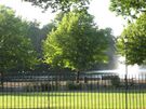
Victoria Park, London

Alexandrovsky Garden, Moscow

Roundhay Park, Leeds


_by_shakko_01.jpg)

National Parks


The normal view of a park is a green area within or near a city or town. Parks in isolated, rural locations covering large, usually wild areas (called "National Park" or "Landscape Park" for example) are a different matter. The tags boundary=national_park, leisure=nature_reserve or perhaps boundary=protected_area should be used instead, not this leisure=park tag. Here is the example of Yosemite National Park in the USA, not tagged leisure=park. The same could apply to state recreation areas in most cases.
Mapping history in the USA
For most of OSM's history in the USA, due to American English usage of "park" as "a large area of land kept in its natural state for public recreational use,"[3] this tag is thusly found also on many areas that are "national parks", "landscape parks" and similar. While this better (though slowly) sorts itself out, the wider world should understand this tag's regional prevalence on more than "small urban manicured green spaces," as in North America it is often applied to what are regionally known as "parks" (but are not in the OSM sense defined here): tracts of land solely for hiking and enjoyment of nature, beaches, campgrounds and other public recreation areas (which can be desert, alpine, wooded...), many of which are large areas and less urban. Some are tagged both leisure=park and boundary=national_park, which does not seem contradictory to many Americans. Again, this (slowly) resolves (especially in California, where the ill-defined park:type=* was often used as a crutch), so it is likely this paragraph will be deleted as USA park tagging hews more closely to the semantics of leisure=park (and other parks) defined here. How that unfolds and how long that takes remain to be seen. United_States/Public_lands attempts to unravel some relatively complex tagging which significantly overlaps with the many sorts of "parks" in the USA. The goal is to harmonize tagging of "parks" in the USA with OSM's definition here by better tagging areas in the USA now denoted as leisure=park with other, more appropriate tags, such as leisure=nature_reserve, boundary=national_park or boundary=protected_area.
There may be other areas in Western Asia / the Middle East where, for example, large deserts contribute to similar (mis-)use of this tag. This wiki's Talk page is a suitable place to discuss or document this.
Possible tagging mistakes
See also
- boundary=national_park - large, government-decreed area for human recreation and protection of environment or cultural heritage
- leisure=nature_reserve - for wildlife or geological / special interest features, managed for conservation, study, research opportunities
- boundary=protected_area - includes wilderness, marine protection areas, heritage sites and similar areas
- place=square - a town square, typically crossed by streets, also pedestrian areas or rarely green areas
- landuse=recreation_ground - an open green space for general recreation (can be public or private)
- landuse=village_green - a distinctive part of a village centre
- landuse=grass - a smaller area of mown and managed grass
- leisure=garden - a place where flowers and other plants are grown
- tourism=theme_park - an amusement park where entertainment is provided by rides, game concessions, etc.
External links
 Park
Park- Urban park on Wikipedia
References
- ↑ "urban park" is not restricting its location to big cities. leisure=park may be also in small town and in villages or in rare cases even outside settlements
- ↑ synonyms from https://en.wikipedia.org/wiki/Urban_park - note that as usual OSM definition may be not match Wikipedia definition, though as of April 2019 this entry matches leisure=park nearly exactly
- ↑ Apple MacOS X Mojave Dictionary (US English), "park," (noun) Definition 1 (US variant)