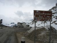
Tag:mountain_pass=yes
Jump to navigation
Jump to search
| Description |
|---|
| Marks the highest point of a mountain road, railway or path as it passes over a crest. |
| Rendering in OSM Carto |
| Group: properties |
| Used on these elements |
| Useful combination |
| See also |
| Status: approved |
| Tools for this tag |
|
mountain_pass=yes marks the highest point of a mountain road, railway or path as it passes over a crest.
For more details see mountain_pass=*
See also
This tag page is a stub. You can help OpenStreetMap by expanding it.
Similar pages for structural reference: Tag:railway=tram, Tag:waterway=dock.
Similar pages for structural reference: Tag:railway=tram, Tag:waterway=dock.
