Tag:natural=arete
Jump to navigation
Jump to search
 |
| Description |
|---|
| A thin, almost knife-like, ridge of rock which is typically formed when two glaciers erode parallel U-shaped valleys |
| Rendering in OSM Carto |

|
| Group: natural |
| Used on these elements |
| Useful combination |
|
| See also |
| Status: approved |
| Tools for this tag |
|
natural=arete is used to tag an arête: A thin, almost knife-like, ridge of rock which is typically formed when two glaciers erode parallel U-shaped valleys. Arêtes can also form when two glacial cirques erode headwards towards one another.
See arête on Wikipedia
How to map
- As a way: draw a linear way along the ridgeline of the arête, the line of highest ground, then add:
If the arête has a name, add name=*
Often an arete will connect with a natural=peak and may also include a natural=saddle.
Gallery
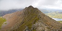
Crib Goch, Snowdonia, Wales

