Tag:place=square
 |
| Description |
|---|
| A town or village square: a (typically) paved open space, generally of architectural significance, which is surrounded by buildings in a built-up area such as a city, town or village. |
| Group: places |
| Used on these elements |
| Useful combination |
| See also |
| Status: de facto |
| Tools for this tag |
|
The tag place=square is used to map a town square or village square: a typically hardscaped (usually paved) open space, generally of architectural significance, surrounded by buildings in a built-up area such as a city, town or village. While most squares are public space, there are some instances of private squares (e.g. Inge-Beisheim-Platz in Berlin), which may be publicly accessible but cannot be considered public space if the owner can impose her rules at will.
Also known as a city, urban, public or market square, the majority of the area of this feature is paved and suitable for open markets, concerts, political rallies, and other events that require a solid surface. They are usually named.
However, a feature that includes the word "Square" in its name may be a street or road junction (junction=yes) or a mostly vegetated area used for recreation (leisure=park) instead of a place=square (however, a significant part of squares are actually emphasizing road junctions, so this is not a reason for exclusion).
Squares occur in different occasions in the city, for example to mark a bend in an arterial road (axis), to emphasize big traffic junctions (nodes), to emphasize significant buildings (e.g. castles, train stations, public buildings like city halls and museums, etc.), to structure the city following an urbanistic concept (e.g. to introduce rhythm), to provide space for specific activities (e.g. different kinds of markets, customs at city gates). Like buildings and roads, in the ten thousand years of the history of urbanism, the way squares are built has been subject to significant development, and has to be seen against the background of the local culture. Generally, when a street is created in order to provide a link (connection, people and vehicles moving), a square is set up to provide a place to stay.
How to map
Place a node ![]() at the center of the square, and add a place=square tag together with name=*.
at the center of the square, and add a place=square tag together with name=*.
Or draw the outline of the square as an area ![]() . Typically the outline includes all objects on the square, including streets, pedestrian areas, green areas, buildings, but excludes objects at the square, such as surrounding buildings. When a square is surrounded by streets having different names, the square polygon is usually mapped within the streets, not including them.
. Typically the outline includes all objects on the square, including streets, pedestrian areas, green areas, buildings, but excludes objects at the square, such as surrounding buildings. When a square is surrounded by streets having different names, the square polygon is usually mapped within the streets, not including them.
The precise area of paved surface which is open to pedestrians may be mapped and tagged with highway=pedestrian + area=yes, excluding any fountains, vegetated areas, parking lots or other features which are not part of the open pedestrian area.
Tags use in combination
- name=* – for the name of the square
- wikipedia=* – the title of a wikipedia article
- wikidata=* – a link to a wikidata object
- architect=* – name of the architect
- start_date=* – inauguration date / year / century /...
Gallery
Examples for squares with flowing boundaries
- Berlin, Platz der Vereinten Nationen (ex-Leninplatz), socialist post-war modernism


Examples for squares which are not or only partially delimited by buildings (but by other, usually man made, elements like walls, colonnades, other squares)
- Rome, St. Peter's Square (elliptical) and Piazza Pio XII (adjacent polygonal square behind, formerly Piazza Rusticucci)
(also an example for a square in front of a significant building, to emphasize the building)


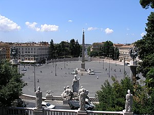
- Rome, Piazza del Popolo

.jpg)


Examples for urban squares completely delimited by buildings
- Rome, Campo dei Fiori


Examples for squares where the center is not accessible
- Berlin, Strausberger Platz, socialist post-war classicism and modernism


Examples with a high percentage of soft scape
- Berlin, Platz der Luftbrücke (also an example for a square in front of a significant building, to emphasize the building), German fascism, post-war modernism


Examples for squares in connection with city gates
Commonly there have been open spaces in front (outside the town) and open spaces or squares behind (inside the city) of city gates, which frequently have evolved later into town squares.
- Berlin, Pariser Platz, inside the walls


- Berlin, Platz des 18. März, outside the walls


Other examples for squares at city gates
- Holstentorplatz, Lübeck, Germany
- Eschenheimer Tor, Frankfurt am Main, Germany
- Hallesches Tor, Berlin, Germany
- Kottbusser Tor, Berlin, Germany
- Platz vor dem neuen Tor, Berlin, Germany
- Potsdamer Platz (external), named after the former Potsdam Gate, and Leipziger Platz (internal, octogonal and visible in the model)


.jpg)
- Piazza della Porta Maggiore (internal) and Piazzale Labicano (external) osm
See also
- highway=pedestrian + area=yes – to map the area of a paved square which is an open pedestrian area (historically in OSM also used for the whole paved area of a square including roads)
- area:highway=pedestrian – an area representation of a linear pedestrian street – not commonly used for squares
- leisure=park – to map the area of a square which is an urban park
- place=neighbourhood – for the surrounding neighbourhood, which may share the same name as the square
- amenity=marketplace – for a public market, often held in a market square or market hall
- junction=yes – for a junction of streets or roads
- man_made=courtyard – for typically smaller areas, normally fully enclosed by a building or wall.
External links
- Wikipedia:
![[W]](/w/images/2/24/Wikipedia-16px.png "Wikipedia") town square
town square