Tag:seamark:type=anchorage
Jump to navigation
Jump to search
| Description |
|---|
| An area in which vessels anchor or may anchor. |
| Group: marine navigation |
| Used on these elements |
| Status: de facto |
| Tools for this tag |
|
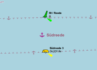
An area in which vessels anchor or may anchor.
If the vessel can moor here, use seamark:type=berth
How to map
Set a node ![]() or draw the outline of the area
or draw the outline of the area ![]() and add
and add
- seamark:type=anchorage
- seamark:anchorage:category=See table below
- seamark:name=* - name
| Category (CATACH) | seamark:anchorage:category | Definition |
|---|---|---|
| Unrestricted anchorage | unrestricted | An area in which vessels anchor or may anchor. |
| Deep water anchorage | deep_water | An area in which vessels of deep draught anchor or may anchor. |
| Tanker anchorage | tanker | An area in which tankers anchor or may anchor. |
| Explosives anchorage | explosives | An area set apart for anchored ships discharging or receiving explosives. |
| Quarantine anchorage | quarantine | An area where a vessel anchors when satisfying quarantine regulations. |
| Sea-plane anchorage | seaplane | An area in which sea-planes anchor or may anchor. |
| Small craft anchorage | small_craft | An area in which yachts and small boats anchor or may anchor. |
| Small craft mooring area | small_craft_mooring | An area in which yachts and small boats moor. |
| Anchorage for periods up to 24 hours | 24_hour | An area in which vessels anchor or may anchor for periods of up to 24 hours. |
| Anchorage for pushing-navigation vessels | pushing | An area where pushing-navigation vessels may anchor |
| Anchorage for a limited period of time | limited_period | An area in which vessels may anchor for a period of time not to exceed a specific limit. |
| Anchorage for other vessels than pushing-navigation vessels | non_pushing | An area where other vessels than pushing-navigation vessels may anchor |
| Anchorage for dry cargo vessels | dry_cargo | An area where dry cargo vessels may anchor |
| Anchorage for rafts | raft | An area where rafts may anchor |
Symbol in OpenSeaMap
Click to open the map