Talk:NaPTAN/Local schemes
West Yorkshire - WY Metro
The signs in West Yorkshire are just about all similar to this - http://www.flickr.com/photos/pobice/3365644417/. I'll try find one with the SMS code showing in full, but it looks like most are 450 followed by a 5 digit number --Pobice 21:05, 18 March 2009 (UTC)
- Better photo - http://www.flickr.com/photos/pobice/3373204941/
- This stop appears to have two names. I've used the one from the sign on name and the one from the shelter as alt_name. I believe the sign is the newest hence going for that.--Pobice 22:05, 21 March 2009 (UTC)
Nottinghamshire
Some photos for when people get round to doing Nottingham(shire)
These photos are taken from stops in Rushcliffe, those in the city differ slightly IIRC.
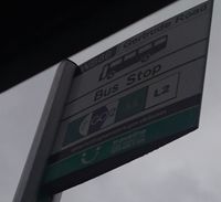
A typical flag on the bus stop showing the old code (WB66), Stop Name (Gertrude Road) and services leaving from the stop (11, LocalLink 2 (L2) - and actually 11C but that's unshown)
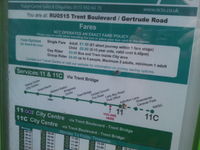
Time table display showing the new stop code RU0515 and new name "Trent Boulevard / Gertrude Road" and the timetable
200px|thumb|Timetable and Full Code Final shot showing the remaining page of the timetable, and also the full code ????RU0515 - unfortunately out of focus - also shows the old code (WB66)
I've noticed that a newly installed stop has a panel with "text this code for times" on it - but no code!

