Talk:Tag:natural=valley
Definition?
This page is good for wikipedia but not for OSM: "A valley is a low area between hills, often with a waterway running through it.".
- What should mappers do if there no river?
- What if river is seasonal (intermittent=*)?
- Should we use this tag for objects without rivers at all? What is "hill"? How step hill should be?
- How we can measure (Verifiability) hill?
This page (or wikipedia) doesn't answer them or at least defines purpose of this tag. Why there new tag? How renders should draw it? Should they ignore this tag? Xxzme (talk) 17:09, 17 December 2014 (UTC)
- "Often" does not mean "always". So of course you can map riverless valleys as well. If you don't like the text, feel free to suggest a better definition.
- For the purpose of this tag, see the "Rendering" section. A DEM does not supply applications with valley names.
- --Fkv (talk) 17:26, 17 December 2014 (UTC)
I've been looking at my country's official maps; in my mountainous region there are some named valleys ("Barranca Calcohualco", "Barranca Tlaltecuino", etc.), and not all valleys are named. If one can interpret a topographic map or an elevation model, it is more or less easy to see where a valley is; however, I think it is only worth mapping a valley if it is named. It doesn't matter if there is a river or not, or if it is intermittent. If the valley is locally known by a certain name, it is worth mapping so that when somebody tells you, "I hiked through Barranca Tlaltecuino" you can just look it up in the map. --FedericoMenaQuintero (talk) 02:33, 3 June 2016 (UTC)
- The fact that something is of interest for showing in a map in some form does not automatically make it mappable in OSM. It has to be verifiably observable in reality for that. Having something named valley as definition does not work. So for this tag to be actually useful it would need to be possible for a mapper to decide what a valley is, independent of the name, and to determine its geometry, independent of the purpose of using it to generate a label in a particular map style with a particular projection.--Imagico (talk) 09:52, 3 June 2016 (UTC)
Verifiability
The definition of this tag as it is lacks verifiability. Specifically the 'low area between hills' is extremely vague. The description also specifically notes the purpose of this tag is label placement and not documenting an observable feature in reality making it essentially codified mapping for the renderer.
- It should rather say "linear depression between slopes" instead of "low area between hills". A valley may be flanked by ridges or mountains instead of hills. A valley is verifiable by increasing elevation perpendicular to it. Of course it may not be clear where the valley starts (e.g. when the topmost part is a cirque) or ends (when it continually widens to a plain), but that's a kind of fuzziness common to most natural features (natural=bay/ridge/strait/etc). After all, cartography is always an abstraction. --Fkv (talk) 00:29, 28 June 2016 (UTC)
- But that would make any river/stream a valley and would disqualify many other types of valley (like in Basin and Range Province) from being such.--Imagico (talk) 08:11, 28 June 2016 (UTC)
- Have a look at what I wrote on the feature page: "Note that valleys and waterways are not necesserily congruent. Rivers are often meandering. There may be multiple branches of the river, or no river at all."
- I don't know much about the Basin and Range Province. According to your link, it makes up a huge part of North America, and contains myriads of valleys. Can you please be more specific? Is there any example for a valley that does not match our definition? --Fkv (talk) 20:44, 28 June 2016 (UTC)
- I was referring to your suggested definition of "linear depression between slopes" and "increasing elevation perpendicular to it" - this would qualify any river/stream as a valley. Regarding Basin and Range - most famous example is obviously the Death Valley which would be clearly disqualified from your definition. Note the Basin and Range valleys are special in mostly being endorheic - there are also plenty of tectonic valleys where this is not the case with complex drainage and relief so your definition does not work either.--Imagico (talk) 21:19, 28 June 2016 (UTC)
- I am not exactly sure where you want to insert "more than a few metres". Generally a linear feature is usually understood to be a one-dimensional feature - the valley floor, the playas here, is clearly a two-dimensional feature and i don't think anyone would seriously map those as linear ways - they are currently coarsely mapped as natural=mud. And even if you would - it would be a non-verifiable mapping, you could with equal justification place this way anywhere along the playas.
- This graphics explains what I mean by "only a few metres":
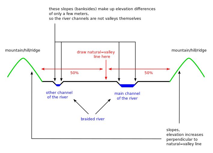
- It hopefully also makes clear that it is verifiable, and why the course of a river is not necessarily identical with the course of the valley. Of course, this is is only an issue with sediment-filled valleys. The course of V-shaped valleys is much more obvious.
- Talking of playas, we do map coastlines anyway, so why shouln't we do the same thing with valleys? Verifiability does not mean sharpness. Every mapper can verify the existence of coasts, bays, valleys etc., even though it may be difficult to abstract them down to points and lines. --Fkv (talk) 10:59, 1 July 2016 (UTC)

- Thanks, that makes your idea much clearer - so you mean you want to define a minimum 'depth' of a valley. This means that any line that is on both sides surrounded by terrain that raises in continuous slope by at least a few meters is considered a valley. That is consistent and verifiable IMO (though occasionally difficult if the slope is not very steep). However it would include quite a few cases i would not usually consider a valley, especially where the large scale topography is very different from the small scale forms of the immediate slopes. And it would exclude most larger tectonic valleys and valleys in arid regions where there is no water flow to maintain the above condition.
- On the other hand if - as you indicate with your sketch - the defining slopes can be interrupted by flat areas of arbitrary extent the situation becomes quite different - you could then cover huge parts of the earth by a dense network of such lines, they would essentially be a skeletonization of the topography - not sure if that makes sense to map in OSM.
- If you call something a valley, it's certainly ok to map it as a valley in OSM. Remember that the primary purpose of valley mapping is to have their names rendered (as OpenTopoMap already does). There's no reason to draw networks of vast numbers of natural=valley lines. A hill inside a valley is quite unusual, and if there really happens to exist such a thing, the local mapper can certainly judge on which side of the hill the valley proceeds.
- I am not totally convinced of the "few metres" text part. It was just a try to distinguish banksides from valleys. You may come up with a better definition. I have come across several definitions for "valley" or German "Tal", but none of them convinces me. I don't think that we need to do a better job than professional geomorphologists. We just need to ensure that mappers and application developers share a common understanding of map features, and that's not too difficult a task in this particular case, as everybody knows what a valley is. Nobody would mistake banksides for valleys, so I would just omit the "few metres" condition. --Fkv (talk) 15:25, 1 July 2016 (UTC)
- Please keep the discussion on topic, this is about how to improve this tag's definition to be verifiable, not about under what conditions something can and should be mapped in OSM - that is a much more general question that is to be discussed elsewhere.
- Personally i do not have the impression valleys can normally be verifiably mapped as linear ways. Therefore i cannot really actively help to improve the definition towards this end. But i see the possibility to find different ways to map valleys that could be verifiable (see below). --Imagico (talk) 16:00, 1 July 2016 (UTC)
- I see nothing wrong with mapping valleys as lines. This is how cartographers have been doing it for thousands of years, and this is how we map ridges and aretes too. Nobody has ever had a problem with that, let alone with verifiability. I have been mapping dozens, if not hundreds of valleys in and around Lower Austria (http://overpass-turbo.eu/s/h5w). Tell me a single one that you find unverifiable, and which aspect of it (name, course, start, end, whatever).
- I agree that the current long description ("a low area between hills") needs a rework - but mainly because it is wrong, not because of verifiability. In respect to the latter, the short definition "a valley" is fully sufficient, as everybody knows that term and/or can look it up in a dictionary, encyclopedia or geomorphological textbook.
- I am just realizing that it's me who copied the wrong description from Wikipedia when I created the page. Sorry for that. I am going to replace the description now. --Fkv (talk) 18:46, 1 July 2016 (UTC)
- Your changed description is better although probably somewhat too restrictive for the common understanding of what a valley is. The self-referential short description is of course a joke. The mapping instructions are self-referential as well by the way, defining valley through valley bottom.--Imagico (talk) 20:14, 1 July 2016 (UTC)
- You may consider the short description a joke, but many map features have short descriptions like that (man_made=telescope: "Telescope"; office=newspaper: "An office for a newspaper."). If you don't like them, improve them. My long description is less restrictive than the definition in the Diercke Wörterbuch Geographie. There are further meanings in Wiktionary etc., but if we included them, verifiability would indeed suffer. I wonder why you keep arguing: Definition too vague, definition too narrow... I am losing hope that you'll ever be satisfied. --Fkv (talk) 21:52, 1 July 2016 (UTC)
- This is not to satisfy me, i am just trying to help this becoming a successful tag (which it is not destined to be at the moment). You - like anyone else - are free to use the tags you want and document how you use them. It is often helpful for example to keep in mind that a good tag description page is useful for someone coming from a completely different environment than your own, speaking a native language that possibly does not have a synonym for the word used as tag value and so on.--Imagico (talk) 22:28, 1 July 2016 (UTC)
valley/gorge
See also mention natural=gorge that has no own page. It is also unclear what should be considered boundary between valley and gorge (or at least what hints which one should be used) Mateusz Konieczny (talk) 20:23, 6 June 2016 (UTC)
- A gorge is just a steep sided valley. Map as a valley, labelling will indicate gorge or ghyll (gill) variety. (unsigned edit by User:Pmailkeey001)
- I see those two rather different. A natural=valley should not have a rendering (except label) and can not be drawn precisely (in most cases). A natural=gorge can be drawn precisely as it is delimited by notable cliffs, could be mapped either as a single way for very narrow ones or left&right cliffs and should have a rendering similar to that of cutting=yes or cliffs along the gorge. RicoZ (talk) 09:22, 19 June 2016 (UTC)
- If you only have valleys rendered as lines or a label node, how can you tell whether another object is in or outside the valley ? There are accuracy issues with many borders - such as where one street name ends and another starts or settlement outer limits - we just have to map the best we can. See "Tagging: A valley is an area" below. -- pmailkeey 2016:6:19:12:40
- Valley types: (feel free to add more)
- Valley
- Gorge
- Vale
- Ghyll
- Head (The start of a valley at the upper extreme)-- pmailkeey 2016:6:26
- A gorge is a steep sided valley or steep sided section of a valley. E.g. the Weichtalklamm (308174702
 308174702) is part of the Weichtal, even though it is currently not mapped that way. Gorges are typically tourist attractions and should be rendered in a special style at least in hiking maps. E.g. the name could be rendered in the same color as other tourist attractions. I also like Rico's idea to render them similar to cutting=yes. Otherwise, treating them like natural=valley would be a reasonable fallback. --Fkv (talk) 02:13, 28 June 2016 (UTC)
minimal size?
Valleys may be small or even extremely small (legth in tens of meters). It is unclear what is recommended method of tagging. Tag:natural=valley, something else, no tagging, tag only named ones? Mateusz Konieczny (talk) 20:25, 6 June 2016 (UTC)
I use to map only named ones, independently of their size. There's no point in mapping valleys without any attributes. --Fkv (talk) 00:45, 28 June 2016 (UTC)
Tagging: A valley is an area
I always map valleys as areas as that is what they are. As for where to draw the edge of the area - same issue applies to settlements, boundaries aren't and don't need to be precise. -- pmailkeey 2016:6:18
- A house is a house, no matter whether it is in the centre or on the outskirts of the settlement. For valleys, it does make a difference whether you are at the bottom of the valley or on a flanking ridge. When you are only a few meters away from the watershed, you can hardy say that you are "in the valley". You are within its drainage area at best. Of course you could map drainage areas, but when a valley divides upwards into two branches, you'll run into problems, because the name=* is valid for only one of them, and that may even be the shorter branch. This is impossible for a renderer to determine from the drainage area, even in combination with a laser-based DEM. --Fkv (talk) 01:22, 28 June 2016 (UTC)
- I too prefer mapping as areas, but it depends on the valley. Sure some it's probably easier and best to map as a linear way along the waterway, but not all. Some examples that I don't see how could be done as a linear way are https://www.openstreetmap.org/way/889441949 and https://www.openstreetmap.org/way/889441951. --Aharvey (talk) 06:01, 29 December 2020 (UTC)
- Thank you for those examples. The second one is an excellent example of why mapping valleys as rough areas is not verifiable to be true or false. Take a look: https://www.openstreetmap.org/way/889441949#map=12/-34.7340/150.5808&layers=C - is this mapping the floor of the valley, or the top of the hills on each side, or somewhere midway up the slopes? Why does the vally stop just before the reservoir to the left instead of continuing downstream further? It is not possible to get local people to agree on if a valley is only the flat area at the bottom, or if it includes part of the surrounding hills, or goes all the way to the top of the ridge. It's also usually not possible to decide where it ends on the open side, in this case where river flows out.

- The first way also shows similar problems - why doesn't it cross the river/reservoir to include the part just across? How far up the hills should it go? https://www.openstreetmap.org/889441951#map=12/-33.7948/150.3553&layers=C - Instead if you map a node at the center of each of these valleys, that can be confirmed to actually be in the valley. Cartographers can use the contour lines or a DEM (digital elevation model) to estimate the size of the valley more precisely than these rough sketches, if needed for label placement for example. --Jeisenbe (talk) 07:50, 29 December 2020 (UTC)
- I won't repeat the comments also made on changeset about this here. My first example was greatly improved by another mapper into a relation at https://www.openstreetmap.org/relation/12107413. In that case it's now very well defined based on the clear cliff edges which surround the valley together with the government Geographic Names Board description of the extent. --Aharvey (talk) 10:56, 29 December 2020 (UTC)
- No it's not a drainage basin ("A drainage basin is any area of land where precipitation collects and drains off into a common outlet"). The drainage basin for the outlet here is much larger, extends mostly to the north to include the townships which are on the plateau and not part of the valley. It's named valley, but I know that the tag is not selected based on the feature name. The wiki says valley is "an elongated natural depression flanked by ridges or ranges of mountains or hills, and at least partially formed by fluvial degration." now this one is a natural depression, but part of it is flanked by ridges, the other part by cliff edges (which based on the wiki is more like a gorge) so it doesn't quite fit into either description. Either way there is a a clear and precise border for this valley/gorge and so we need a way to map that area. Another mapper has suggested a new tag essential natural=valley_area but I'm not so sure about that. --Aharvey (talk) 04:43, 4 January 2021 (UTC)
Valley as relation?
There is no agreement how to map it as area because there are only partial borders. So how about a relation that would have as members those borders where it is easy to agree - such as the ridges/arretes delimiting the valley on the side. Could also have a member for the main waterway forming the valley or "child" valleys inside the larger valley. I think with such an approach it would be possible to:
- place a label correctly
- get a realistic estimate of the size of a valley
- decide whether a location is "inside" or outside a valley with a confidence value depending how close to a "missing" border it is
RicoZ (talk) 10:57, 26 June 2016 (UTC)
- I haven't found anything good about 'relations'. They just seem to cause all sorts of problems with editing. There's no need for things to be related when connected other than by conventional means. I can understand a need where an area has a hole in it. Valleys don't go up to the ridges. How far they go up the sides is debatable and likely variable from one location to another. There's absolutely no reason to relate a valley to a river. --pmailkeey 2016:6:26
- Relation, not multipolygon. Nobody likes MPs, that's for sure. The fact that relations and MPs still exist proves that there is nothing better in many cases.
- As of the valleys, if there is a ridge, crest or similar it is safe to assume it the boundary of the valley?RicoZ (talk) 13:00, 26 June 2016 (UTC)
- No, a valley does not continue up any hill or mountain - as clearly, that is part of the hill or mountain. It is the low-lying land between such. -- pmailkeey 2016:6:26
- As of the valleys, if there is a ridge, crest or similar it is safe to assume it the boundary of the valley?RicoZ (talk) 13:00, 26 June 2016 (UTC)
- I believe the definition which is taken over from Wikipedia is less than optimal as there are many valleys (V-shape valleys) that have no lowland at all. Take the village Verdasio in the Valley Centovalli (https://it.m.wikipedia.org/wiki/Verdasio). There is no lowland at all in that valley, the place Verdasio is substantial elevataion above the deepest point of the valley and is still considered part of the Valley
- Even if you would assert that the valley "stops" somewhere in the middle of the mountain slope the crest can be seen as a very good "outer border" delimiter.
- 21:31, 26 June 2016 (UTC)
- Yes, in principle a relation type that documents the verifiable aspects of a feature like a valley but avoids to force the mappers to enter non-verifiable information and is overall mapping orientated and not rendering oriented would be a good approach. There are however a few requirements that are necessary for this to have a chance:
- It must not be specific to valleys, a concept that is tailored to this and does not work for the dozens of different geographic features that are difficult to represent with the normal feature types (node, way, area) will never be widely supported by applications.
- There would need to be a well defined standard for mappers how to use it and for applications how to interpret it
- For this to gain popularity it would be necessary to have reference implementations for common interpretation tasks (rendering as well as analysis tasks like determining basic quantitative properties like size, aspects of the shape etc.)
- Even with these requirements met it would still be a serious uphill battle to get a concept like this widespread acceptance since the whole vector geodata world is strongly tied to the classic feature types and there would be strong resistance to deal with anything else.
- --Imagico (talk) 17:43, 26 June 2016 (UTC)
- What we are talking about here is a way to describe a one- or two-dimensional geometric entity - not unlike a multipolygon and ultimately not specific to geographic applications. It probably makes sense to design it as such. A multipolygon requires you to fully delineate the boundary of this 2d entity as 1d lines. If you don't want to or cannot do that in a verifiable way you need to think about other ways to document verifiable information about an entity like this and how this information can be represented in ways that is easy to map and to interpret in a consistent and robust way.--Imagico (talk) 11:13, 28 June 2016 (UTC)
- Those ranges are not just geometric entities with more or less fuzzy boundaries. The boundaries have specific properties depending on the type of the object. One example - a mountain range is typically delimited by valleys. Valleys are delimited by ridges. If interpreted wrongly the conclusion would be the mountain range ends at the "last" ridge. RicoZ (talk) 09:42, 1 July 2016 (UTC)
- Well - you should not have relations containing relations anyway so whatever new type of relation you create to represent valleys and mountain ranges it would contain ways and nodes as members. If you consider a valley to be delimited by a ridge to some extent that ridge (presumably mapped as a way) would be a member of that relation with a certain role. And this ridge would of course have its own tags identifying it as a ridge.
- The valley would be a relation with ways like natural=ridge as members delimiting the boundaries. However mountain ranges are frequently delimited by valleys - in common language and description in books. So ideally a mountain range relation would have some members of relation type valley as boundaries. However it appears many mountain ranges are already mapped as multipolygons so it may not be worth thinking about this special case. RicoZ (talk) 13:10, 1 July 2016 (UTC)
- Together with another mapper we mapped a few as relations: https://www.openstreetmap.org/relation/12107413, https://www.openstreetmap.org/relation/12107614, https://www.openstreetmap.org/relation/12107671. I find that it actually works really well where there are clear boundaries like a cliff line or ridge line. It does become much harder where there is no clear cliff or ridge. --Aharvey (talk) 11:04, 29 December 2020 (UTC)
Valley on node
Hi, could we map valleys on nodes? this page shows that we could map valleys on nodes and ways but not on relations and polygons. But when I map with JOSM it says that valley must be mapped only as a way not a single node. which one is correct? Sometimes it is difficult to determine area of a defined or named valley but a node can show that an important or famous valley is near here.
- In any case of doubt, the Wiki is correct and JOSM is wrong. Of course you are allowed to map a valley as a node when you lack information about its geometry. On the other hand, I can hardly believe that there is a valley these days that you can't spot in an aerial image or a SRTM background image in your editor. Can you give an example? --Fkv (talk) 23:33, 5 February 2018 (UTC)
- "In any case of doubt, the Wiki is correct and JOSM is wrong" I would not say that, opposite is frequently true. Maybe "in case of doubt validator is wrong"? I used https://josm.openstreetmap.de/wiki/Help/Action/ReportBug to report numerous problem with JOSM validator (and nearly all were quickly fixed) Mateusz Konieczny (talk) 07:30, 6 February 2018 (UTC)
balka
The page suggests using valley=balka as a useful combination. Since there is no associated page for that tag, I wonder why it is useful, and what it even means in English. As a non native speaker, it is really not clear to me, especially when I can't find that word in any online English dictionary. The valley key doesn't seem to be documented either.
- Agreed, undocumented tags should not be recommended. I'll remove this suggestion. --Jeisenbe (talk) 10:27, 5 August 2019 (UTC)
One sided valleys
What about one sided valleys,
__   ___
  \__|
with a cliff on the other side? Jidanni (talk) 23:54, 19 October 2019 (UTC)
- I'd call that a valley with an asymmetrical profile, rather than a one-sided valley, as it does have two sides anyway. You can tag it with natural=gorge (which is a special case of a natural=valley) if the left side is also quite steep. Of course, mapping the natural=cliff cannot be wrong either. --Fkv (talk) 06:43, 20 October 2019 (UTC)
Nonsense
This is another one of those nonsense tags which contributors feel complelled to add just beacuse they've a desire to put their mark in OSM. "A solution looking for a problem". The few examples I've seen are so inaccurately drawn, they add no quality to the database. As a linear way there's no indication of scale. We already have waterways & various geological tags in OSM and accurate contours can be rendered. --DaveF63 (talk) 10:37, 28 August 2020 (UTC)
- Which part of "The main purpose of natural=valley features is to tell database users the name" do you not understand? Did you ever consider to read a page before judging it? --Fkv (talk) 20:25, 28 August 2020 (UTC)
Valleys with side branches.
Some valleys have side branches, so not just a single way from top to bottom but also secondary way/s.
This might be better in OSM as a relation - using the waterways as members thus not replicating the way but using it for this secondary feature.
Note: This maintains the 'approved' use of the waterway/low point of the valley as the method to map the valley.
Warin61 (talk) 05:38, 10 February 2021 (UTC)
- Side branches have side branches themselves etc. That's a fractal structure. Why don't you just take the longest branch? --Fkv (talk) 16:55, 11 February 2021 (UTC)
- The one I am aware of has a main 'river' with several 'streams' flowing into it. The length of the side branches would rival the length of the main 'river', they are not small/short. Officially the valley name applies to all of these. At the moment there are tagged as a site relation - best I could advise to the original mapper. I prefer to include all real present data in OSM. Sorry I don't have the OSM reference to hand at the moment. Warin61 (talk) 09:36, 12 February 2021 (UTC)
Mapping the valley by area.
For those who want to map a valley by area I would suggest using a different tag e.g. natural=valley_area. This would maintain the natural=valley as the low point through the valley so renders can deal with that using some method, while an area can be dealt with in some other way.
Please consider verifiability such as discussed above and for mountain ranges. By using a separate tag for the area problems may be more easily seen and some methods worked out to deal with them.
Warin61 (talk) 05:48, 10 February 2021 (UTC)
- I still don't see a reason to map a valley area, but I agree that a separate tag would be the way to go. area:natural=valley comes to mind, to be consistent with area:highway=*. However, a value area can be part of another value area, while this is not the case for highway areas. So you'd need to give the value area the same name as the value line, or to put them in a relation, to define which valley area belongs to which valley. --Fkv (talk) 17:19, 11 February 2021 (UTC)
Valley with waterway: valley_name
The page suggest that in case of a waterway a new line sharing the same nodes as the waterway should be created. This seems quite cumbersome. Why not create a new tag valley_name which could be added to the waterway. The valley_name could be rendered in black if the waterway has no name or, if both names are present, they could be rendered alternating. This would simplify the mapping (in particular with iD) and valley names would be visible on the map (which presently does not seem the case). Get (talk) 09:04, 23 February 2021 (UTC)