Talk:Tag:power=line
Voltage
shouldn't it be voltage instead of voltages? -- Schusch 12:40, 26 November 2008 (UTC)
- i correct that because i'm pretty sure -- Schusch 12:56, 26 November 2008 (UTC)
Location Aboveground/underground?
Would it be appropriate to have
- location=aboveground added as a default value
so then if your adding the tag, you have the option of making it 'underground' In JOSM, this could be added as an option with default value. --acrosscanadatrails 10:20, 12 March 2009 (UTC)
Substation?
What does one do for a power distribution substation? power=substation perhaps? -Fennecfoxen 19:02, 12 April 2009 (UTC)
Intersections with streets
I don't understand the last sentence about more accuracy by adding nodes when intersecting roads. That sounds totally bogus. 1. Why should that improve accuracy? 2. There's no physical link between roads and powerlines, they are on totally different heights, it's not possible to get from one tho the other (as a node would imply). So this is plain wrong. --Fröstel 08:46, 25 June 2009 (UTC)
Non-power lines
How to tag non-power lines, such as telephone cables? --Skippern 02:37, 28 August 2010 (BST)
Frequency of line
I know most of the world distributes high voltage energy as 50Hz, but at least Brazil have exemptions here, the distributed energy is 60Hz, and at least one mayor power line (Iguacu power plant near Foz do Iguacu/Puerto de Iguacu on the border between Brazil/Argentina/Paraguai to São Paulo) is DC (0Hz). Is this information that is interesting to tag, and in so case, how should this be tagged? I would hazard to use frequency=* on the power lines. --Skippern (talk) 16:59, 1 February 2013 (UTC)
- The frequency=* tag is documented, also for power line use. However, the power line wiki is missing a link to the frequency tag. In northern Europe the frequency tag is widely used on power lines. For the 50/60 Hz grids (dependent on region) it may be unnecessary to use it but for example in Germany it is the way to distinguish the normal power grid from the railway power grid (16.7 Hz). frequency=0 is the standard tag for indicating HVDC transmission lines. So no problem adding frequency tags to power lines. It is especially important to use the tag on lines that use a frequency different from the default value for the region. --polderrunner (talk) 20:22, 1 February 2013 (UTC)
- Frequency shouldn't be added on lines but on circuits relations involving lines because the line is only composed of conductors, which aren't designed for a specific frequency.
- The operator of the line choose to operate a given line at a given frequency to transmit power according to needs. Then it's only a circuit matter and not a line one.
- It have to be said that a line can be intended for a particular usage (linemen won't add a 3rd conductor for a HVDC line), but the design goes in cables=* and wires=* on power lines while the circuits relation get the frequency=* matching the operational conditions Fanfouer (talk) 15:06, 1 January 2018 (UTC)
Multiple circuits with different voltages
There appear to be no set way to tag lines that have this. I've seen quite often a mix of 66kV and 22kV on two level wooden h-frame towers. The 22kV line then branches off at times to end in a small transformer. --Gazer75 (talk) 12:15, 1 January 2018 (UTC)
- You can use voltage=voltage_a;voltage_b.
- circuits=* key gives the amount of circuits taking the line.
- Finally, actual circuits can be mapped with relations which are not yet fully defined. Have a look to this proposal. Fanfouer (talk) 14:55, 1 January 2018 (UTC)
First paragraphs are too long
Could someone edit the first paragraph or two to concisely define the use of this tag only? Right now there are digression about how power circuits work and other details which are not relevant to how this tag is used in Openstreetmap. --Jeisenbe (talk) 05:25, 10 December 2019 (UTC)
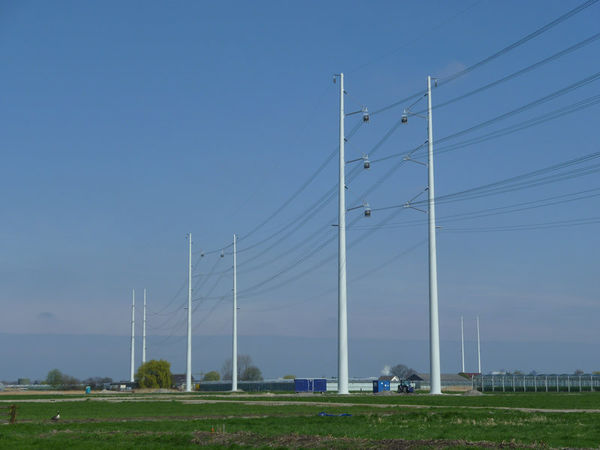
Photo of a large tubular steel structure labeled power=pole
On the bottom of the page there is this picture, with the caption:
"High voltage power lines are usually mounted on towers, but may be supported by poles, like this. Such should not be tagged power=minor_line" [1]
![[1]](https://wiki.openstreetmap.org/wiki/File:07147jfSunsets_Paddy_vegetable_fields_Upig_Bagong_Barrio_San_Ildefonso_Bulacanfvf_18.jpg)
See similar examples from power=tower:
- https://wiki.openstreetmap.org/wiki/File:Steel_pole_400_Hermosa_Duhat_Balintawak_transmission_line.jpg
- https://upload.wikimedia.org/wikipedia/commons/thumb/5/5c/FvfNLExPampanga2280_21.JPG/460px-FvfNLExPampanga2280_21.JPG
- https://wiki.openstreetmap.org/w/images/thumb/d/dc/Wintrack-800.jpg/600px-Wintrack-800.jpg
Would these "poles", which appear to be tubular steel towers, be tagged as power=tower + structure=tubular + material=steel? Or is it a power=pole? Or could be both? --Jeisenbe (talk) 01:40, 14 January 2020 (UTC)
- I would use tower for such large lines that are used for transmission. I actually use tower for all lines 45kV and above to make it simple when mapping in Norway. With some exceptions when old towers made for higher voltage are reused for 22kV. Gazer75 (talk) 01:58, 14 January 2020 (UTC)
- With some exceptions when old towers made for higher voltage are reused for 22kV. Does the structure of the supports is changed with voltage? To me, tower or pole is not about voltage nor transmission vs distribution. Any metal lattice work support got power=tower from me whatever its size and we may apply the distinction made between man_made=tower vs man_made=mast : we climb inside a tower and outside a mast. Fanfouer (talk) 12:39, 14 January 2020 (UTC)
- The exception I can recall that I've yet to map is along E16 near Hønefoss. https://www.mapillary.com/map/im/h-cr2zUZjCBudlKpHssT0w I belive those once supported 45kV lines, but got replaced by the 2x132kV next to them.
- Pretty much all 33kV and below use the T and π design of similar height(8-15m), and made of wood. Feel like calling those a tower is to much. Gazer75 (talk) 13:11, 14 January 2020 (UTC)
- The exception I can recall that I've yet to map is along E16 near Hønefoss. https://www.mapillary.com/map/im/h-cr2zUZjCBudlKpHssT0w I belive those once supported 45kV lines, but got replaced by the 2x132kV next to them.
- With some exceptions when old towers made for higher voltage are reused for 22kV. Does the structure of the supports is changed with voltage? To me, tower or pole is not about voltage nor transmission vs distribution. Any metal lattice work support got power=tower from me whatever its size and we may apply the distinction made between man_made=tower vs man_made=mast : we climb inside a tower and outside a mast. Fanfouer (talk) 12:39, 14 January 2020 (UTC)
- I would use tower for such large lines that are used for transmission. I actually use tower for all lines 45kV and above to make it simple when mapping in Norway. With some exceptions when old towers made for higher voltage are reused for 22kV. Gazer75 (talk) 01:58, 14 January 2020 (UTC)
I'm mapping my local area's transmission grid and I've come across several scenarios where independent three-phase circuits interact with poles in a complex way, and I would like some advice on the most semantic way to map and tag them.
Scenario 1: Two circuits of equal voltage leave a Substation A from independent bays. They share power poles their entire run to Substation C, where they connect to independent bays. Along the way, the lines pass Substation B. One, and only one, of the circuits hits a pole-mounted switchgear and links to Substation B.
Scenario 2: Two circuits of equal voltage leave Substation A from independent bays. They run on independent poles for about a third of their distances. Then, they converge to the same poles, and share poles for about another third of the distance. Then, they split apart again, taking independent paths before both ending up at Substation B in independent bays.
Scenario 3: Two circuits of different voltages coming from distinct substations on independent poles converge at an obstacle crossing. They share two poles, one on either side of the crossing, before diverging once more.
For each of these scenarios, what is the best method to map these? I can think of two arrangements off the top of my head... either map each circuit as an independent Way and have them overlap nodes or map them as five separate Ways, two on each end where the lines are independent, then one combined Way with cables=6 where they share poles. The first option keeps it evident which circuit goes where -- the entire circuit can be highlighted in tools like JOSM, and it can be given a distinct name= tag that clarifies where its termination sites are -- but at the cost of having Ways overlap, which makes them harder to select and tell apart. The other option keeps things cleaner with no pesky intersections, but information about each distinct circuit is lost, the Way objects are now discontinuous, and the name= tag for the shared Way would become needlessly long and complex.
Which option is preferred for each case? Or is there an even better solution?
- Do not make overlapping ways for each circuit. Instead tag segment with circuits=2 and voltage=voltage1;voltage2. For scenario 1 you probably have to use circuit relations to get full detail. You can still map lines with the use of circuits=*, cables=* and voltage=*. You are welcome to join #osm-infrastructure on IRC to chat and give visual examples. Gazer75 (talk) 23:51, 15 February 2020 (UTC)
- Thank you to ask such questions, it's great to see people involving in power circuits mapping :)
- As Gazer75 says, we use to map a single power=line way independelty of amount of supported circuits. Look for circuits=* key and power routes relations
- It's useful to deal with Y power circuits also (maybe a 4th scenario beside your first 3). Live examples : 6194774
 6194774 involving 2-circuits 130110647
 130110647 Fanfouer (talk) 11:08, 16 February 2020 (UTC)
- I've read the circuits=* page and it says in no uncertain terms to never mark a line with the circuits=* tag unless the number of cables=* is not a multiple of 3 or the line is actually a power=cable, runs underground, and the number of physical conductors it carries is unknown/unclear. Are you suggesting that I should use the circuits=* tag anyway even though neither of these cases apply? Fawfulcopter (talk) 18:25, 16 February 2020 (UTC)
- I'm using simpler rule : use circuits=* when there are more than one system operating on the line independently from cables=* (which covers all mentioned cases and cables=6, cables=9 and so one). Consumers may not be able to deduct there are 3-phases systems with cables=6 only. Even if it's optional it's not wrong to add it finally. Fanfouer (talk) 00:29, 17 February 2020 (UTC)
- I've read the circuits=* page and it says in no uncertain terms to never mark a line with the circuits=* tag unless the number of cables=* is not a multiple of 3 or the line is actually a power=cable, runs underground, and the number of physical conductors it carries is unknown/unclear. Are you suggesting that I should use the circuits=* tag anyway even though neither of these cases apply? Fawfulcopter (talk) 18:25, 16 February 2020 (UTC)
Multiple line orientation notation
Often visiting each tower on a 100 km stretch of a high voltage line reveals signs indicating we are actually dealing with two lines:
- Nurdsburg - Fartsville line, attached to the northeast side of each tower
- Blitsburg - Nartsville line, attached to the southwest side of each tower
Well, in the Description field we can write
Nurdsburg - Fartsville line is on the northeast side, Blitsburg - Nartsville line on the southwest.
But that doesn't seem very systematic.
Maybe have fields
- Line 1: Nurdsburg - Fartsville
- orientation: northeast
- Line 2: Blitsburg - Nartsville
- orientation: southwest
What about curving lines? Well OK, then also allow entering
- mountain side, vs.
- sea side, etc.
Jidanni (talk) 16:58, 17 November 2020 (UTC)
- Hi Jidanni. This is a question for Proposed_features/Power_routing_proposal and a relation matter. Indicating several names (or concatenating them in name=*) on the power=line is convenient for render but should be obtained from relations that the line is member of.
- The power routing proposal is currently staled because of API limitations but it's possible to create power circuits relations now. Fanfouer (talk) 17:18, 17 November 2020 (UTC)
3D rendering: don't forget the sag
When one day anybody finally gets around to 3D rendering, don't forget the sag! [2]
Same even for telephone wires.
Jidanni (talk) 04:39, 11 February 2021 (UTC)
- That's a good point and it's not easy to compute it from current publicly available data.
- It needs not only the cable material but section and mechanical properties as well.
- There is an undergoing project in France to involve operators to publish such data but it's not complete already. Wait and see Fanfouer (talk) 18:54, 12 February 2021 (UTC)
What is the meaning of construction:*= ?
This text was just changed: "If a power line is technically designed for another voltage than it's operated, it was suggested that this may be tagged with construction:voltage=*, however this conflicts with the meaning of construction:*=*." - new text in italics.
A search at taginfo does not show any particularly consistent use of the format "construction:<other_key>" - several other common forms are similar to construction:voltage=* - see https://taginfo.openstreetmap.org/search?q=construction%3A
@Kovposch: why do you think construction:voltage=* is a problem? --Jeisenbe (talk)
- Same as in Key:construction. It would mean a new voltage is being "constructed", ie perhaps it's being upgraded. A minimally better term would be "construct", or better make it a physical property of the line. I don't believe you can use a different frequency than constructed, considering https://taginfo.openstreetmap.org/keys/construction:frequency. In general, you may observe from Overpass Turbo construction:voltage=* is often used with https://taginfo.openstreetmap.org/keys/construction:electrified and railway=construction. Other property examples may include https://taginfo.openstreetmap.org/keys/construction:surface. ---- Kovposch (talk) 12:16, 3 March 2021 (UTC)
- I second @Kovposch:, despite it's not established, it's too near of Comparison_of_life_cycle_concepts#Lifecycle_prefix_.28.3Cstatus.3E:.3Ckey.3E_.3D_.3Cvalue.3E.29.
- As voltage=* use to be extended by additional properties, like voltage:primary=*, i think voltage:construction=* or voltage:design=* would be actually more consistent.
- construction:voltage=* has been introduced on this revision and I don't remember about a discussion. Fanfouer (talk) 21:19, 3 March 2021 (UTC)