Talk:WikiProject Gaza Strip
Title for project - Gaza Strip
Being a little pedantic, Gaza is the city, the area we are discussing is the Gaza Strip. Should we move this page to 'WikiProject Gaza Strip'. Currently we are perpetuating confusing terminologyPeterIto 19:24, 6 January 2009 (UTC)
Satellite Imagery
I'm rather concerned about the plans to pay for satellite imagery and then use those for mapping. This is an expensive way of doing things, will result in copyright issues, and just generally isn't the way things are done. We should be adding to existing knowledge, not paying to use other people's knowledge.
- If that's an offer to go and get some satellite imagery for free, then yes please. :) --Richard 18:07, 7 January 2009 (UTC)
- To be clear we are proposing the buy a mapping licence for the photography so that we can legally derive mapping so there should be no copyright issues. As a result of this we will have much more recent and complete photography that we currently have. We have no other available sources from which to map it present and I don't see why we should rely on begged photography in all cases when there are people offering to pay for it. Is this not a healthy development in the OSM project which will greatly increase our ability to extend OSM coverage? PeterIto 07:15, 9 January 2009 (UTC)
Moving discussion section from main page to this page
I am intending to move the discussion section (previously called questions) from the main page to this talk page soon unless anyone objects PeterIto 12:45, 9 January 2009 (UTC)
- Done PeterIto 05:13, 10 January 2009 (UTC)
Splitting page and creating a 'Gaza Strip' article
I think this article is getting too long and unmanageable and I suggest we hive off the section of this article which details the regional structure, the towns and building etc into a separate article titled 'Gaza Strip'. We will keep this article for discussing 'project Gaza' and the new article will be for describing the Gaza Strip itself and the talk page can be for organising any associated research PeterIto 12:45, 9 January 2009 (UTC)
- Peter, agree that we should move the section on regions and geographic details to another page. How about a subpage? WikiProject_Palestine_Gaza/Region Mikel 17:56, 9 January 2009 (UTC)
- Done PeterIto 05:13, 10 January 2009 (UTC)
Administrative Boundaries
I have added the administrative boundaries for the different Governatures very roughly. If anyone can find a more accurate source then they go do with some attention. (PeterIto)
Yabna Refugee camp
I have added the 'Yabna Refugee camp' based on recent news report but I am not sure if it is the same or different from from the Rafah Refugee camp? (PeterIto)
- I have now removed the Yahna refugee camp because it only appeared briefly in the news and I think it is possiby an old name not now in common usage PeterIto 07:39, 9 January 2009 (UTC)
- Keep in the db with the "old_name" tag? This could help stop confusion on the name in the media Mikel 10:18, 11 January 2009 (UTC)
- Personally I have not had confirmation that it is an old name for the same place. I think we need some local knowledge to confirm this PeterIto 22:28, 11 January 2009 (UTC)
Classification of roads
Tagging urban ways - How should we be mapping different roads and paths in urban areas. Should all ways in towns be pedestrian or residential or tertiary even if they are unpaved?
Tagging rural ways - I have bee tagging most paved roads as unclassified and unpaved roads as 'track'. Is that ok? (PeterIto)
- Another option would be to tag both types as highway=road (road that I do not know more about that it is a road) and add surface=paved vs surface=unpaved to differentiate between them.--sanna 11:06, 8 January 2009 (UTC)
- road is not fully accepted by renderers - for example it is not shown on the cycle layer. However I am not sure if YourNavigation will route vehicles along a track. Any more thoughts before we change anything? PeterIto 07:39, 9 January 2009 (UTC)
I have mapped urban areas using residential or unclassified as a first pass without knowing if vehicles are actually able to pass through. I guess we are going to need to wait for some local knowledge before sorting that out. Can someone added 'from yahoo photography' or something to all roads I have entered - I think JOSM can do that but I haven't used JOSM for some time now. (PeterIto)
- I can do this source change, but you have also "CIA world database II" source, you want that changed to yahoo also? --Sergionaranja 09:44, 8 January 2009 (UTC)
- Not sure what was sourced from CIA, I only used yahoo for a rough urban boundary PeterIto 07:39, 9 January 2009 (UTC)
Road Names
I changed the name Salahadeen Road to Salah El Deen Road. I know the CIA map had Salahadeen but OCHA has Salah El Deen and this seems to fit with a google search of news reports related to the above two names. I also added Al Karama road from OCHA maps. I noticed below a comment that this should be acceptable fair usage. However if this is not the case please let me know. neilP
OpenStreetBugs
I've marked a few questions on OpenStreetBugs . Can someone familiar with the area have a look. Dmgroom 13:26, 6 January 2009 (UTC)
- I have been updated the dual carriageway sections so that they will work like a normal dual carriageway but have no special knowledge of the placePeterIto 07:39, 9 January 2009 (UTC)
Schools
Has someone already asked the UNRWA if we can add the schools, whose GPS coordinates they gave the IDF, onto the map? (NeilP)
- Not to my knowledge - please try it but do put a note on this page to say that you are on the case - if we hear nothing we will assume you are not! It would certainly be a great win to immediately have all the schools, some of which I think are going to be very small and possibly not visible on aerial photography in the way that schools in the UK/USA are by their playgrounds and big flat buildings.PeterIto 18:06, 7 January 2009 (UTC)
- I've sent an email to Sami Mshasha, the UNRWA spokesperson in Jerusalem letting him know about the project and asking specifically about the location of schools. (NeilP)
Place classification
- I have adjusted the 'cities' to be 'towns' so that they render more clearly - the city rendering was just too large. I know that they places are really classed as cities but is seems appropriate in the circumstances. I have also tagged some camps as 'suburb' when they have effectively become part of the town (eg Rafah camp). I have also adjusted the positions of the 'place' marked to avoid text clashes on osmarender - again a slightly dubious technique in general but is should make it clearer in the short termPeterIto 07:39, 9 January 2009 (UTC)
- I am about to change the abandoned settlements from villages to localities. If anyone has a better plan, feel free to change them again. --Liber 14:18, 13 January 2009 (UTC)
- It is good tag. Does it get rendered? The examples given on the feature page linked to from above are not rendered, however it turns out that the features themselves have been removed from the dataset in those cases as far which is not that useful. PeterIto 01:25, 14 January 2009 (UTC)
- Yes - it shows up at a smaller scale than a village does in both renderers
Place Names
I have adjusted the names of some towns to match the English and the Arabic spelling in the relevant Wikipedia articles. These are different from some other spellings I have seen and are different from what was there in some cases. If someone knows that I am wrong please change it. (PeterIto)
As I have been trawling the net I see various names and spellings for the same place e.g. Gaza, Ghaza, Ghazzah. There is little consistency between various agencies. This comes about as there is no single method of translating from arabic to latin. I think that we need to agree how to place naming.
Issues
- Should the primary name be the 'English' or Arabic spelling? According to Key:name it should be the local name, which in this case would be arabic. However as there is great international interest in this region using just the arabic spelling would give poor end-user experience. I know we are not supposed to tag for the renders, but currently the main maps only display the <name> tag.
- Agreed, I think we need to code so the renders produce good advice in the short term.PeterIto 20:07, 10 January 2009 (UTC) We can rapidly change the tagging if/when the renderers get updated.
- Proposal - The <name> tag has the arabic spelling followed by the 'English' spelling. In addition an entry <name:ar> and <name:en> are added to reflect each of these components.
- Fine by me.PeterIto 20:07, 10 January 2009 (UTC)
- Spelling - there are multiple spellings in Latin
- Proposal - The primary English spelling is as defined on the appropriate wikipedia page. Additional spellings are added using the <alt_name> tag.
- Should the tag not be alt_name:en=?PeterIto 20:07, 10 January 2009 (UTC)
- 'Al-' prefix - should it be there or not. See this wikipedia article for more information. In particular the section "Entry on Names"
- Proposal - Only add the 'Al-' prefix if the relevant wikipedia entry for the location uses it.
- Sounds good to mePeterIto 20:07, 10 January 2009 (UTC)
As I am far from being an expert in this region nor in arabic, I welcome a better set of proposals. --Pshipley 13:19, 10 January 2009 (UTC)
- I think the above makes a lot of sense. I have associated minor suggestions against the above proposals, but equally I am not an expert in the area.PeterIto 20:07, 10 January 2009 (UTC)
- All sounds reasonable for me at this point. When there's more time to consider, we can open up wider discussion with Arabic OpenStreetMap community, Wikipedia community, Global Voices, Meedan, and others, as to a standard way for Romanization of Arabic words. Ideally, place name finders should account for all the common variations; could be done automatically by Romanization->Arabic->Romanization procedure. Mikel 18:22, 11 January 2009 (UTC)
Camp or RC?
Some places are called 'camp', 'refugee camp' and others 'RC'. Can I suggest we use 'camp' and not 'RC' which most people are not going to understand anyway. PeterIto 22:11, 10 January 2009 (UTC)
Rafah Refugee Camp location?
The BBC normally position the Rafah Refugee camp north of Rafah on maps such as this one - we have it to the south and have 'Tall-as-Sultan' where they show the camp. Are we right? I think we are. I believe that Tall as Sultan is where people from the Canada camp ended up. PeterIto 11:41, 10 January 2009 (UTC)
- I think the BBC are wrong and we are (more) correct, there is a bit on the history of the camp here --Pshipley 13:52, 10 January 2009 (UTC)
- Ok, I have looked at it again and I have moved the town of Rafah much further south to fit all other sources. We have the Rafah Camp in the right place, but but we have the town much to far north. Wikipedia has both the site of the Rafah Camp and also Rafah too far north. Geonames agrees with Wikipedia and is also wrong - they all put Rafah (town) where the camp is and the camp where Tall as Sultan is. PeterIto 22:44, 10 January 2009 (UTC)
- Everything still doesn't hang completely together because the Rafah Humanitarian Assessment Report on page 27 shows the town centre where we show the camp (and also north of Al Brazil which it calls Brazil) is and doesn't mention the camp at all! I think we probably leave it south where the other sources show it. I think we need some local knowledge to do much more here. PeterIto 22:57, 10 January 2009 (UTC)
- From what I have pieced together, working down the Egyptian border N-S - first we have Tall-as-Sultan, then Rafah (the original old town) and finally Rafah Refugee Camp (which is made up of various section like Brazil, O-Block, J-block etc, named after the sequence built, who paid, or which nationality of UN forces were there) - The wikipedia page states this sequence also. Note, Rafah town (the original bit) was tiny before the RC camps were built, in 1922 600 people, in 1967 11k , now there are 130k, so it is easier to find camps than 'original' town. Effectively the collective is 'Rafah City' with the camps and the 'original town' being suburbs. --Pshipley 00:06, 11 January 2009 (UTC)
- Again I think we now need local knowledge to say where the 'centre' is in 2009. Clearly it was originally near where the camp now is, but has it moved south as some maps show or not as other maps show? It seems impossible to say with the sources available to us. lets leave it in the south in the newer section for now. PeterIto 22:28, 11 January 2009 (UTC)
Level of Detail
Some concern has been expressed by outside agencies as to the level of detail to add to the map. I for one would appreciate some guidance --Pshipley 13:52, 10 January 2009 (UTC)
- We are getting advice from different NGOs and some have suggested that it may not be useful to add more detail than is generally available from other sources. It may be worth creating an accurate map of the following: Roads visible on the photography (we need more photography to complete that job), the main settlements (we have a few more to add of those but are becoming better than most other sources now), and the main facilities (hospital, large mosques, cemeteries, archeological sites etc). We are getting advice from some NGOs that it may not be appropriate to add more detail than that but I am just passing on what I have heard.PeterIto 20:07, 10 January 2009 (UTC)
- It is hard for me to see any risk. Undoubtably, the Israelis have much better imagery and maps than we could ever produce, and it doesn't seem like there is any risk in providing maps to anyone else. Perhaps I am missing something, however. --Liber 02:32, 12 January 2009 (UTC)
Sheikh Khalifa City
I notice this new place has been added to the map. The foundation stone has been laid[1] and it has a wikipedia article[2] so it is underway, however there was no footprint on the ground visible in June 2007[3]. I have added a small 'landuse=construction' for it, I have reclassified it as a village for the time being (not that the funder of the project will like that!), added '(construction)' to its name and removed the place=morag node which is now historical. Btw, Potlatch seems to hate fields with mixed arabic and english where the arabic comes first and I think there is a stray bracket in the name. Should this Potlatch problem mean that we put english first until we can get it sorted?PeterIto 07:13, 11 January 2009 (UTC)
- I've been thinking about this more - in English we read left-right, arabic is R-L, so if we retain the original method of English followed by Arabic then it is 'right' for both languages. --Pshipley 15:44, 11 January 2009 (UTC)
Local knowledge
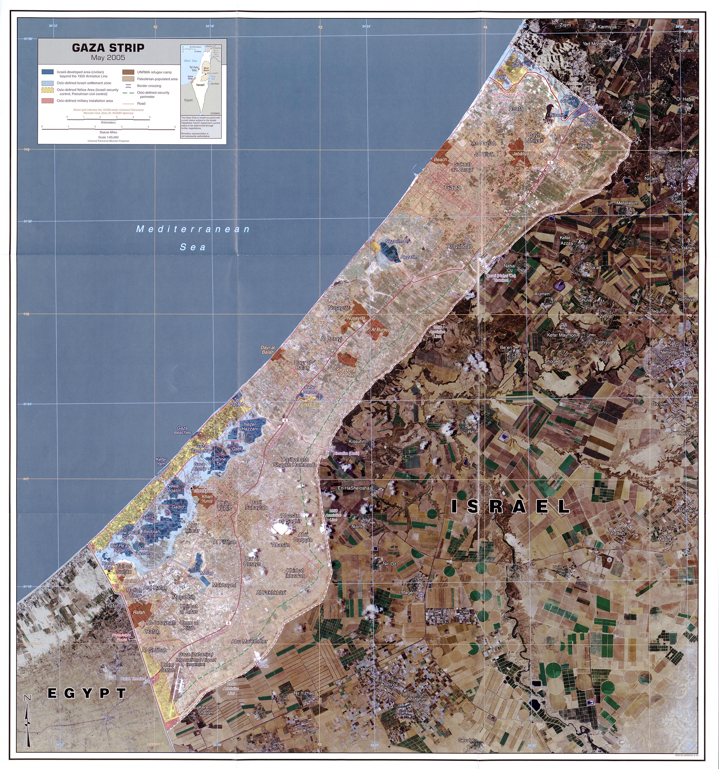
I think we are at the point where we need local knowledge to add the rest of the place names. I have been looking at the different maps sources and they vary wildly. They vary in what settlements they include, what spelling they use and where they put them. When one compares this CIA map (May 2005) with the UNOCHA map (July 2005) the maps are pretty much unrecognisable except for the bigger settlements. Other maps have big differences as well so it really isn't really possible to determine what is correct without local knowledge. PeterIto 22:09, 11 January 2009 (UTC)
'Fair Use'
We have now collected a good body of information on Gaza that is copyright to someone or other. In addition we have further maps and information that doesn't state that it is copyright, but that is likely to be the intention.
I have already annotated the map of Rafah with some additional Suburb names taken from an OCHA map citing 'UN OCHA - fair use' at the source. To what extent can we add additional content from these sources without getting approval from the copyright holder?
There is a good wikipedia article on fair use. Do people have an opinion what would be acceptable and not acceptable? I would suggest that we now have a sufficiently mature map based on CCbySA data that we could add suburb names for Gaza and also major facilities on the strip from some of the other maps without problem - especially as the source for much of this data is UN OCHA. I do suggest that we give the source as UN OCHA - 'Fair Use' rules. I am also putting this question on legal-talk. PeterIto 13:25, 12 January 2009 (UTC)
- The conclusion of the discussion on legal-talk was that 'fair-dealing' only works in a few countries, including the USA and not the UK where I am based. There is the concept of 'fair-dealing' in the UK which I is evidently different and not helpful. We are not sure what happens if a USA resident adds a small amounts of (c) data to the DB and it is then 'exported' - can a UK resident add a bit of (c) data to the DB as long as the data is sourced in the USA - probably not. PeterIto 01:41, 14 January 2009 (UTC)
Mailing list?
Is their a mailing list for this project? If not, would it be useful to create one? talk-ps is the obvious name, if we follow the country code convention at http://lists.openstreetmap.org/listinfo That way it could remain in place for longer term use, esp by Arabic speakers. --LeedsTracker 03:45, 22 January 2009 (UTC)
Editing from Wiki Project Gaza Strip WMS
What source=* tag for the 2m Gaza WMS server?
I've been deriving data from the recently set up Gaza 2m WMS server, what source=* tag should I use to indicate that the data is derived from it? --Ævar Arnfjörð Bjarmason 11:44, 17 February 2009 (UTC)
- until other thing is said im going to tag source as <source=WPGS_WMS2m> (WikiProjectGazaStrip WMS 2 meters) --Sergionaranja
- I and others tagged source=gaza_2m --John07 17:15, 17 February 2009 (UTC)
- Ah, I started tagging it as source=gaza_2m as that was the first thing that came to mind, but source=WPGS_WMS2m looks better and carries more information so I think we should use that instead. --Ævar Arnfjörð Bjarmason 18:25, 17 February 2009 (UTC)
- whatever is fine. if Ævar agrees with "WPGS_WMS2m" then i´ll keep that, at any time we can decide to use something else and it will easy to do so.--Sergionaranja 21:28, 17 February 2009 (UTC)
- I changed the existent source=gaza_2m tags to source=WPGS_WMS2m to be consistent. --Ævar Arnfjörð Bjarmason 23:28, 17 February 2009 (UTC)
- whatever is fine. if Ævar agrees with "WPGS_WMS2m" then i´ll keep that, at any time we can decide to use something else and it will easy to do so.--Sergionaranja 21:28, 17 February 2009 (UTC)
- Ah, I started tagging it as source=gaza_2m as that was the first thing that came to mind, but source=WPGS_WMS2m looks better and carries more information so I think we should use that instead. --Ævar Arnfjörð Bjarmason 18:25, 17 February 2009 (UTC)
How should i tag the source, if i correct a street with source=landsat while using the WPGS_WMS2m imagery? source=landsat, WPGS_WMS2m ? --John07 14:08, 18 February 2009 (UTC)
- just leave source=WPGS_WMS2m and erase the old one. if your correction is because you have got a better source then erase the old source. WPGS_WMS2m source is the best landsat we have got at the moment. Someday someone will physically survey with a GPS, then it will be changed once again, to source=survey which will be better than WPGS_WMS2m.--Sergionaranja 15:03, 18 February 2009 (UTC)
Destruction tags
there are some tracks that go over landfill, farmyards, roads and buildings that seem to be tank traces, im taging them as | highway=track | tracktype=grade3 | note=seems to be tank tracks | --Sergionaranja 22:07, 17 February 2009 (UTC) they are now retaged as | war=tankrolling | note=seems to be tank tracks | until something is decided, if is deletion then select all "note=seems to be tank tracks" and delete. contact me if you don't know how --Sergionaranja 08:57, 4 March 2009 (UTC)
- I propose war=* to tag war related issues as "shell_hole"(along with "width"=diameter and "depth"), "destroyed", "tankrolling"...(this last one maybe better than tank track, that can be misunderstood as -builded for tanks- instead of -destroyed by tanks-). any thoughts on this?--Sergionaranja 11:51, 19 February 2009 (UTC)
- I believe we should only be showing permanent features and that tank tracks are not permanent. Shell holes might be if they are big enough (many became fishing ponds in Vietnam) but the ones in Gaza don't seem to be that big. I found the inclusion of tank tracks in the north east of the strip very confusing and have removed them. Possibly that was a bit rude and I should have just de-tagged them enough that they didn't render on the MapNik map - apologies if that was the case but I only found this comment afterwards and missed the response to my post on the subject on talk. It does sound sensible to add information about the destruction in a way that doesn't render on the main maps and I would be happy to help with tagging these features when something suitable is agreed.PeterIto 08:19, 2 March 2009 (UTC)
- no bad feelings. im the "one mapper" and as i said in the response in the talk list I agree it was confusing. Maybe we are not ready yet to tag war or natural disaster issues but it might be nice to have an scheme for that, the principal renders probably are not the right place to show them but temporary disaster dedicated projects can use them until the info is needed. The most important thing for this to work is to have up to date info on ground. Which is not the case.--Sergionaranja 14:29, 2 March 2009 (UTC)
JOSM presets for highway=road and source=WPGS_WMS2m
From John07 on the mailing list - how to create a JOSM tagging preset for highway=road and source=WPGS_WMS2m:
- Download the
 Gaza-road-icon.
 - Open your favourite text editor and insert the following:
<annotations>
  <item name="road-source" icon="[PATH TO ICON]\Gaza-road-icon.png">
      <key key="source" value="WPGS_WMS2m" />
      <key key="highway" value="road" />
  </item>
</annotations>
- Save it as gaza-preset.xml
- Open JOSM
- Open the Preferences, go to the Map Settings (3rd tab)
- Add your file at the "Tagging Preset Sources"
- Restart JOSM
- If you want, you can move the preset in your toolbar for quick access (Preferences, Toolbar customization)
- You might also want presets for
 highway=residential and/or
  highway=track --LeedsTracker 01:11, 27 February 2009 (UTC)
Should destruction of war in 2014 be updated in the map?
SBS published an UN report, which says that satellite image taken on August 1 shows 2493 structures have been destroyed, 1243 severely damaged and 1652 moderately damaged, when compared to the image taken on July 6. (Source: [4]) Should areas of severe damage be updated in the map? If yes, how do you tag those areas? Landuse=brownfield? building="impacted"? Waldrenner (talk) 21:23, 1 September 2014 (UTC)
Permission to bulk edit
SwiftFast_bot is making some useful name tag edits in Israel. Would it be ok if I also include West Bank + Gaza in the bulk edits?
Details here: https://wiki.openstreetmap.org/wiki/User:SwiftFast/scripts/nameCopy