User:AcousticNewt/areas/Gladstonepark
An area around Gladstone park
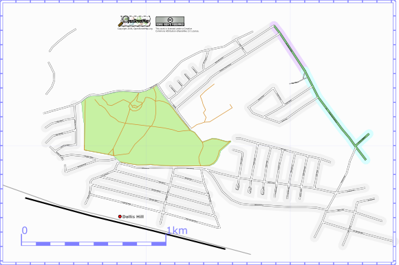
This is an arbitary area around Gladstone Park. The area can be seen on the map
Current map
At the 20th Dec. the osmarender version of the area is:
Progress
| 3 Dec 2006 |
After the storm last night, it turned out to be a pleasant day. Walked down Anson Rd, noted all the names of the streets that branch off. Not on the map yet. Went to Gladstone Park. Walked around most of the paths, there are a few minor ones to be done perhaps. Walked around the duck pond, bowling green and rose garden. Did a complete circle of the park on the roads outside as far as is possible. Did a set of very long roads Helena Rd, Geary rd, Fleetwood rd, Sherrick Green rd, turns into Dewsbury rd @ Cullingworth |
| 14 Dec | I had previously noted down all the roads that branched off Anson Road and I was going
to use the NPE maps to trace them in, but when I heard about the Yahoo! arial images I thought I would wait for them. Well now they are here so I went to the applet. Working with the applet is very slow and also you cannot (AFAIK) add a node in the middle of an existing way. So the way I worked was to just add nodes in the applet along the roads and then download them into JOSM to make the ways and to join them properly to the main road. Seemed to work well and I've added a dozen streets. I look around and fixed up a few places where they seemed to be out by a lot according to the images. |
| 20 Dec | Did a few streets in this area. Also took down names of short branching streets as I passed
them and filled them in from the Yahoo! images in the applet. Started at Mora Rd which turns into Wotton Rd. R onto Langton rd to Temple rd. Short road around the DIY store Longley Way. Down the full length of Gladstone Park Gardens. Back to the broadway down Dollis Hill Av. The closes on the way were: Park Cl, Hill Cl, St Andrews Cl, Lane Cl. Also The Crescent. Colwym rd on the other side, not added to map yet. It was very foggy and at one point I was even using my GPS unit to find out where I was! |
| 30 Dec 2006 |
Cranhurst rd. ends at station parade. Short walk today, the aim being to find the point at which High Road turns into Dudden Hill Lane (and if there is anything in between). side street Linacre rd, ends at Balmoral rd. Roads off Balmoral: onR buxton rd, onL lechemere rd, onR osborne rd , onL huddlestone rd, onR windsor rd, Ends at churchill rd Cooper rd loops back to the main road. Chapter road, other side of Dollis hill station. Just over is Hamilton Road. Deacon rd branches off Chapter. All side roads with names noted above drawn from Yahoo! applet. Even though it was a short walk the Yahoo! applet (and the fact that the streets are fairly dense around these parts) meant that quite a few streets were filled in. |
| 31 Dec |
Off C.B [@Post Office] Oadlands r, ashford rd. Down ashford, turn Pine rd, back along Larch rd. Ashford ends at olive, heber across. back along Cedar rd. |
