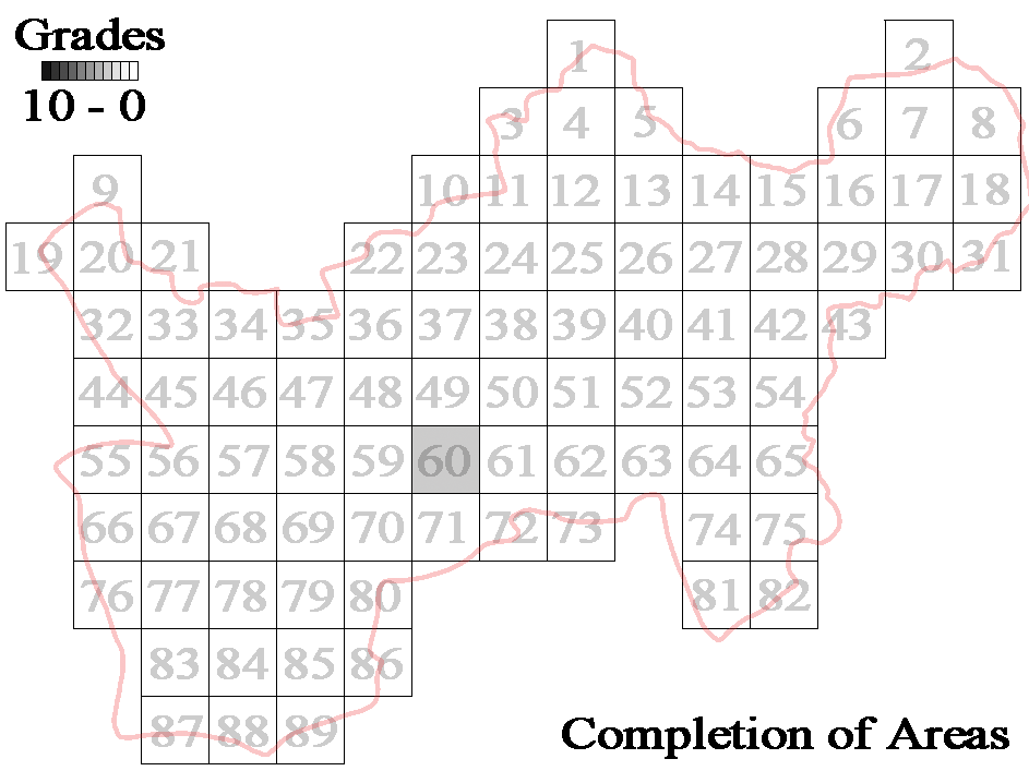
User:Ben/South Northamptonshire

From OpenStreetMap Wiki
Jump to navigation Jump to search
South Wappenham AreaSilverstoneSouth Northmaptonshire z13 tiles.PNG
About this image

60. - South Wappenham Area

Back to the Map

Area Description Render Progress To Do % Done
South Wappenham Area
z13
South Wappenham AreaSouth Wappenham - z13.png
About this image
Detail Level % Complete Notes
1. Roads 100% Done
2. Row's 100% Done - 2 Paths lead to nowhere.
3. Woods 100% Done
4. Tracks and Paths 98% Far West Hazelborough Woods, towards the byway.
5. Rivers (path) 100% Done
6. Rivers (widths) 70% Need to do the stream down the Abthorpe/Wappenham Parish Boundary
7. Lakes 95% Need to finish the pond at Priesthay Farm
8. Power Lines 90% Need to link 2 bits at Priesthay Farm
9. Borders (Fields) 75% 3 Moderately Sized areas left.
10. Small Features 70% Same as Field Boundaries except for the top left area.
Red=Survey - Blue=Edit
South Wappenham - To Do.png
89.80%


61. - Silverstone Area

Back to the Map

Area Description Render Progress To Do % Done
Silverstone Area
z13
SilverstoneSilverstone - z13.png
About this image
Detail Level % Complete Notes
1. Roads 98% Check Stuart Drive and Graham Hill, and the old woodyard also. (South)
2. Row's 90% 1 Dead end, and a few bits missing between West End and the village
3. Woods 95% North Edge of the wood north of the circuit need doing
4. Tracks and Paths 75% South East area is mapped minimally.
5. Rivers (path) 94% Silverstone Brook side streams
6. Rivers (widths) 30% Silverstone Brook needs more info
7. Lakes 95% Probably all done, need to check south east area
8. Power Lines 72% South of Blackmires, and East of Silverstone need doing
9. Borders (Fields) 55% Quite a bit to do
10. Small Features 55% Quite a bit to do.
Red=Survey - Blue=Edit
Silverstone - To Do.png
75.9%