| About Me
|

|
This user submits data to OpenStreetMap under the name
GS25.
|

|
Geochang scribe uses a Garmin Geko 201 and ist willing to answer questions on it from OSM users.
|

|
Geochang scribe submits data to OpenStreetMap using JOSM.
|
|
I am in Geochang, of course.
OSM Activities:
- I did all the OSM mapping in my town. It's complete, but there is still a lot of detail to add.
- I have mapped many motorways and major roads in Korea after numerous bus trips.
- I have written several wiki pages about mapping in Korea.
- I try to promote OSM use as well as encourage new mappers.
- I really want another mapper to be working nearby- then we can have a mapping party!
I have a Garmin Geko 201. It is an excellent device. Having been an OSM mapper for over 2 years now I am getting pretty good at it.
What's this?
A space to put things to show people.
This is a marker post on a hiking trail in Korea. How to tag it?
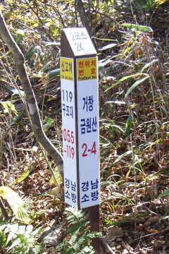
This marker is near Geochang, on Geumwonsan (Geumwon mountain). The image shows the following information:
- On top of the post "2코수", the name of the trail ("No. 2 course"), and "2K", 2 km from the start.
- On the front of the post, "현위치 번호" "Position no." is "거창 금원산 2-4" (Geochang Geumwonsan 2-4)
- On the side of the post, "신고처" "Dial and Inform" "119 구조대" "055-119"
- At the bottom "겅남 소방" (Gyeongnam Fire Department)

