User:Nakaner/Tag:railway=station
| Description |
|---|
| A railway station |
| Rendering in OSM Carto |
| Group: Railway stations |
| Used on these elements |
| Useful combination |
|
| Status: in use |
| Tools for this tag |
|
| This page is a draft! |
Railway stations (including main line, light rail, subway, etc.) are places where customers can access railway services. railway=station should be applied to a node placed at the center of the station area, from the passengers' point of view (i.e. near platforms).
Stations without switches where only passenger trains stops are called halts, not stations. They are tagged railway=halt
In addition, you can use the new public transport tag public_transport=station.
How to map
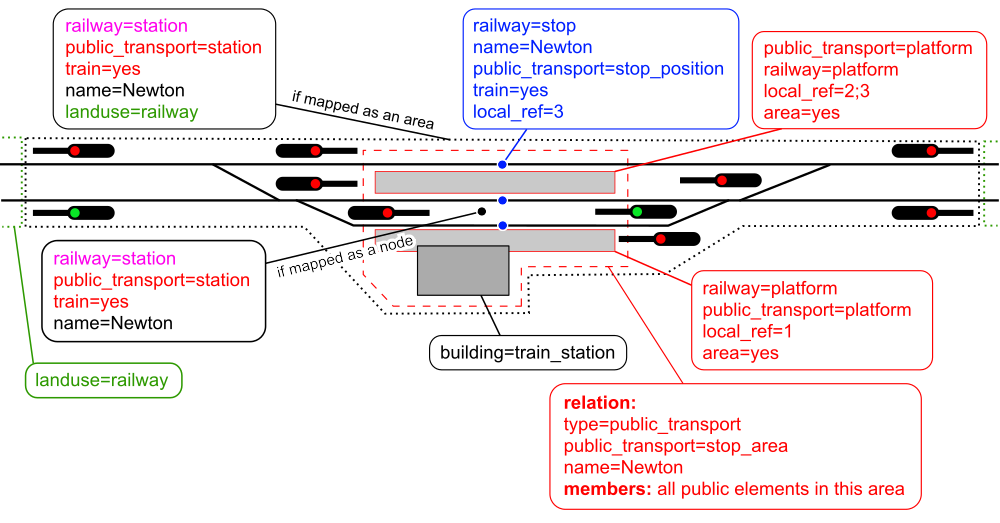
Railway stations are mapped as a node at the center of the station from passengers' point of view. This is usually an unconnected node at the platform area. This node should not be part of a railway track.
If you want to map the station as an area, please consider that different people describe the station area differently. While passengers only have the area around the station building and the platforms in mind, railway staff and railway enthusiasts think of the whole railway area which begins at the entry signal at one side and ends at the entry signals at the other side. Therefore to avoid tagging disputes and editwars railway stations should only be mapped as nodes.
The infrastructural area is mapped as a landuse area and tagged landuse=railway. It is connected to the station node and the landuse area using an operating site relation. The area a passenger has in mind is not mapped directly. Data users can create this area by calculating a convex hull around the stop area relation like OpenBusMap does.
Where a mainline station and metro station (or other railway like station) share the same station building, consider if they should be modelled as separate stations or as a single station. The associated Wikipedia article for the facilities might assist with the decision. If the facilities are run by separate organisations (for example a heritage station next to a mainline station) then it is probably better to map them using two separate railway=station tags.
Following tags can be used on railway stations:
- uic_ref=number which is a unique code for railway stations as registered with the UIC
- name=*
- operator=*
- platforms=*
- station=*
- subway=*
A Simple Railway Station
Things to avoid
- There should only be a single railway=station tag for each station.
- Tram stops and bus stops do not use this tag. They are tagged as simple nodes public_transport=platform + bus=yes or tram=yes next to the track or highway where passengers wait. Together with public_transport=stop_position + bus=yes or tram=yes on the railway=* or highway=* way. The old tag railway=tram_stop for tram stops is still in use. Please add it to new tram stops and do not remove it on existing tram stops.
- Don't forget to add subway=yes if it is a subway station.
- Using the word "station" in the name=* if it is not part of the name printed on signs at the station, i.e. avoid name=Station Newton
- Don't use abbrevations even if the railway company always use them. Use short_name=* in addition.
- If the official name in documents differs from the name printed on signs at the station, use offical_name=*.
See also
- public_transport=station - tagging scheme which covers infrastructure use
- railway=halt - to tag a smaller station.
- building=train_station - useful to map the station building itself. note, that sometimes railway terminal can have name, different from name of railway station - be accurate in such cases, when adding names tags. Name of railway station should be added to railway=station object, name of railway terminal - to buidling=train_station object.
- railway=subway_entrance - to go into a subway station.
- railway=platform and public_transport=platform - to map individual platforms in the station.
- OpenRailwayMap and its feature-rich tagging scheme
Example
See Karlsruhe Central Station for reference. The Gare du Nord, in Paris also applies this model (with references to various networks for long distance lines, high-speed lines, regional commuter trains and subways).
Related terms: ‹ stop › ‹ terminal › ‹ station ›

