User:TobiBS/Kosmos Air Nav Rules
Ideas for what an Aeronautical chart might look like using OSM data. Based on Kosmos AirNav Rules
Adapted to look like official ICAO-Charts: http://www.flightplanner.de/legenden/ICAOD.png in low Zoom Levels.
Other Standards and legends for Aviation Maps
AIP Deutschland
flightplanner.de
FAA
- FAA Ground Charts
- FAA VFR Intro
- FAA VFR Symbols
- FAA IFR Intro
- FAA IFR Symbols
- FAA IAP Intro
- FAA IAP Symbols
Options
| Option | Value | Comment |
|---|---|---|
| MinKosmosVersion | 2.1 | Minimal version of Kosmos needed to use these rules |
| LandBackgroundColor | #FFFFFF | |
| SeaColor | #CADFF4 |
Background areas
| Riverbank | waterway=riverbank | Polygon (Color=#CADFF4) | |||
| Land | natural=land | Polygon (Color=#FFFFFF) |
Ground-level map
This probably wants to be quite faint since it's only for correlating the map with what you can see in VFR view.
Rivers in blue since they will sparkle and reflect and be easy to see.
Large roads are all "just roads" - we don't care what designation they are, other than where it affects their width.
| River | waterway=river | Polyline (MinZoom=5, Color=#CADFF4, Width=5:1;17:6, Curved=true) | |||
| HighwaySecondary | highway=secondary | Polyline (MinZoom=6, Color=#DFDFDF, Width=6:1;17:5) | EliminateSeams | ||
| HighwayPrimary | highway=primary | Polyline (MinZoom=6, Color=#DFDFDF, Width=6:1;17:5) | EliminateSeams | ||
| HighwayPrimaryLink | highway=primary_link | Polyline (MinZoom=6, Color=#DFDFDF, Width=6:1;17:5) | EliminateSeams | ||
| HighwayTrunk | highway=trunk | Polyline (MinZoom=6, Color=#DFDFDF, Width=6:1;17:5) | EliminateSeams | ||
| HighwayTrunkLink | highway=trunk_link | Polyline (MinZoom=6, Color=#DFDFDF, Width=6:1;17:5) | EliminateSeams | ||
| HighwayMotorway | highway=motorway | Polyline (MinZoom=6, Color=#DFDFDF, Width=6:1;17:7) | EliminateSeams | ||
| HighwayMotorwayLink | highway=motorway_link | Polyline (MinZoom=6, Color=#DFDFDF, Width=6:1;17:5) | EliminateSeams |
Obstructions for low-flying charts
Tall buildings (building=* with height>...) should probably be marked here
| PowerLines | power=line | Polyline (MinZoom=13, Color=#FF0000, Width=12:1;17:2) | |||
| PowerTower | power=tower | Symbol (Type=Diamond, MinZoom=14, Color=#FF0000, Density=12:10;17:10, Size=14:4;17:4) | |||
| CableCars | aerialway=* | Polyline (MinZoom=12, Color=#FF0000, Width=14:1;17:3) | |||
| Tower1 | tower=* | Symbol (MinZoom=13, Type=Diamond, Size=14:1;17:8, Color=#FF0000) | |||
| Tower2 | man_made=tower | Symbol (MinZoom=13, Type=Diamond, Size=14:1;17:8, Color=#FF0000) |
Tall buildings
| TallBuildings | IsTaggedWith(e,"height") AND ValueNum(e,"height") > 100 | Polygon (MinZoom=13, Color=#ff0000) |
Airspace
| Airspace | aeroway=airspace | ||||
| .Controlzone | class=D ctr=yes | Polygon (MinZoom=8, MaxZoom=13, BorderDashStyle=Dash, Color=#20FF0000, BorderColor=#0000FF, Width=12:1;17:5) Text (MinZoom=8, MaxZoom=13, Color=#FF0000, TagToUse=class, TextMode=WayCenter, FontName=Arial, FontStyle=bold, FontSize=13:8;17:12, TextLineOffset=100%) Text (MinZoom=8, MaxZoom=13, Color=#FF0000, TagToUse=upperLimit, TextMode=WayCenter, FontName=Arial, FontStyle=bold, FontSize=13:8;17:12, TextLineOffset=0%) Text (MinZoom=8, MaxZoom=13, Color=#FF0000, TagToUse=upperLimitType, TextMode=WayCenter, FontName=Arial, FontStyle=bold, FontSize=13:8;17:12, TextLineOffset=-100%) |
|||
| .Restricted | class=restricted | Polygon (MaxZoom=13, BorderDashStyle=Solid, HatchStyle=BackwardDiagonal, Color=#0000FF, BorderColor=#000000FF, Width=12:1;17:5) Text (MinZoom=8, MaxZoom=13, Color=#0000FF, TagToUse=ref;class, TextMode=WayCenter, FontName=Arial, FontStyle=bold, FontSize=13:8;17:12, TextLineOffset=100%) Text (MinZoom=8, MaxZoom=13, Color=#0000FF, TagToUse=upperLimit, TextMode=WayCenter, FontName=Arial, FontStyle=bold, FontSize=13:8;17:12, TextLineOffset=0%) Text (MinZoom=8, MaxZoom=13, Color=#0000FF, TagToUse=lowerLimit, TextMode=WayCenter, FontName=Arial, FontStyle=bold, FontSize=13:8;17:12, TextLineOffset=-100%) |
Reporting Points
| Reporting Points CTR | aeroway=reportingpoint | ||||
| .Mandatory | mandatory=yes | Icon (MinZoom=9, MaxZoom=13, IconUrl=http://wiki.openstreetmap.org/images/e/e4/Reportingpoint_mandatory.png, Width=13:30;17:30) Text (MinZoom=9, MaxZoom=13, Color=#0000FF, TagToUse=ref, FontName=Arial, FontStyle=regular, FontSize=13:8;17:12, TextLineOffset=-200%) | |||
| .Not Mandatory | mandatory=no | Icon (MinZoom=11, MaxZoom=13, IconUrl=http://wiki.openstreetmap.org/images/f/f5/Reportingpoint.png, Width=13:30;17:30) Text (MinZoom=12, MaxZoom=13, Color=#0000FF, TagToUse=ref, FontName=Arial, FontStyle=regular, FontSize=13:8;17:12, TextLineOffset=-200%) |
Stuff within airports
This should go only on the approach plates, not on the navigation chart
| Apron | aeroway=apron | Polygon (MinZoom=14, Color=#808080) | |||
| Taxiway | aeroway=taxiway | Polyline (MinZoom=14, Color=#000000, Width=12:1;17:5) | |||
| Taxiway Text | aeroway=taxiway | Text (MinZoom=14, Color=#000000, BorderColor=#E000000, BorderWidth=2, BackgroundColor=white, TagToUse=ref;name, TextMode=WayCenter, FontName=Arial, FontStyle=bold, FontSize=13:8;17:12) |
Helicopter facilities
Just default icon from Kosmos General Purpose Rules
| HelipadNode | aeroway=helipad | Icon (MinZoom=12, IconUrl=http://wiki.openstreetmap.org/images/f/f7/Helipad20.png, Width=12:5;17:20) |
Runways
Note: these need to be not-to-scale later - the airport diagram comprising its runways needs to be a big symbol even at low zoom
| Runway | aeroway=runway | Polyline (MinZoom=11, Color=#000000, Width=11:10;17:10) | |||
| Runway Text | aeroway=runway | Text (MinZoom=14, Color=#000000, BorderColor=#000000, BorderWidth=2, BackgroundColor=white, TagToUse=ref;name, TextMode=AreaCenter, FontName=Arial, FontStyle=bold, FontSize=13:8;17:12) |
Airport labels
We need to be able to combine lots of different fields' data into one infobox for the airport, e.g. name, ICAO, IATA, frequencies, and put a border/background around the whole lot
| IcaoCode | aeroway=airport | Text (MinZoom=9, Color=#3761DF, TagToUse=icao, FontName=Arial, FontStyle=regular, FontSize=9:11;17:15, TextLineOffset=60%) | |||
| AirportName | aeroway=airport | Text (MinZoom=9, Color=#3761DF, TagToUse=name, FontName=Arial, FontStyle=regular, FontSize=9:11;17:15, TextLineOffset=-50%) |
TODO: does OSM use aerodrome (how quaint) or airport?
Low-zoom airport labels
| LowZoomAirport | aeroway=airport | Text (MaxZoom=9, Color=#3761DF, TagToUse=icao, FontName=Arial, FontStyle=regular, FontSize=3:4;9:11) | |||
| LowZoomAirport2 | aeroway=aerodrome | Text (MaxZoom=9, Color=#3761DF, TagToUse=icao, FontName=Arial, FontStyle=regular, FontSize=3:4;9:11) |
Screenshots
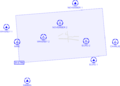
Control Zone and reporting points
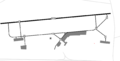
Taxiway markings

