User talk:Blackadder
Hi Andy how are you creating those graphs, they are really a nice addition! If you want to graph more things I have all the stat pages from 22 aug until now on my page.
- I Copied the stats table from the wiki into spreadsheet and created the charts. Printed to pdf and converted to jpeg. Bit manual bit hey it works!
WikiProject United Kingdom
Hi Andy, Thanks for updating the Motorway progress page at WikiProject United Kingdom with details about the M6 (Toll), I hope this will be a useful way of coordinating and tracking progress. One tip: If you enter ~~~~ in the Checked by column then the Wiki will automatically convert this to your user name and a date/time stamp (eg 80n 12:00, 11 Dec 2005 (GMT)). This will be useful later to be able to revisit roads that haven't been checked for a long time. 80n 12:00, 11 Dec 2005 (GMT)
Server Status
Hi, I see you moved the Server Status off of the front page. I can understand why, but I really think it gives a much worse impression if the site is not working and there is no obvious indication of the problem.
Anyone looking at the site at the moment will get a bad impression go away and 'never' come back. At least if they see something large and clear that says all is not well then they 'might' come back.
For the rest of us - it at least makes it clear that there is a general problem and not something local to their network or browser (not everybody is subscribed to the mailing list and not everybody reads every post).
Ideally I'd prefer it to be even more up-front on the very first page. Hidden away where you have moved it to is not useful or helpful (IMHO) - it will easily become outdated. Anyway I'm sure most of the time it will say "100% health, 100% performance" which would be a very positive statement :). 80n 12:12, 7 Feb 2006 (GMT)
- I hear you but I prefer the front page of the wiki to be principally a contents page with an introduction. Ideally, there would be a link from the view/edit homepage to the status page. I haven't hidden it away, its just a single click away from the main page. As far as I can tell, mostly the system is working as of now, at least to the extent that the regular changes being made will permit. Blackadder 12:41, 7 Feb 2006 (GMT)
- I agree that the ideal is a link from the view/edit page. I like the summary by service. Very important when there are several separate servers/site involved. I think it would be useful to have a chronological view since otherwise its kind of hard to know how fresh the information is. Kind of like this: http://www.demon.net/helpdesk/networkstatus/statusandmotd/index.html 80n 19:58, 7 Feb 2006 (GMT)
- I also like the way Blueyonder do it by having a set of buttons green and red to show those services with issues and then more detail in a timeline. Not sure we can get it that fancy on a wiki page but worth a look.Blackadder 22:32, 7 Feb 2006 (GMT)
- I agree that the ideal is a link from the view/edit page. I like the summary by service. Very important when there are several separate servers/site involved. I think it would be useful to have a chronological view since otherwise its kind of hard to know how fresh the information is. Kind of like this: http://www.demon.net/helpdesk/networkstatus/statusandmotd/index.html 80n 19:58, 7 Feb 2006 (GMT)
Acer n35
Hi Andy, I saw you're using an Acer n35 and I'm considering to buy one. It seems to be the same as the Navman PiN 570, with the navigation software being the only difference: Acer n35 comes with PowerLoc Destinator 3 on the SD card (right?), while the Navman has 32 MB of extra ROM on board to store the Navman Smart St 2005 software. When you bought the Acer, did you compare it to the Navman unit? --LA2 20:40, 8 Feb 2006 (GMT)
- Not exactly, I based my selection on a review of several GPS PDA units in PCPro magazine Issue 134 Dec 2005. The Labs review included both the [Acer n35 and the Navman PiN 570, which came close, but the Acer took the prize based on being slightly cheaper and a slightly better performance from the navigation software. However they noted that the build quality was slightly better on the Navman and it also bundles the western Europe maps whereas the Acer was UK and Ireland only (although the review was presumably for UK units anyway). The Acer has a 256MB SD card with the Destinator 3 product on it. I actually brought a 1GB SD card and moved Destinator to that so I can also add a pile of music to listen to. As I recall the 256MB card was nearly half full with the preinstalled software.Blackadder 10:46, 9 Feb 2006 (GMT)
==
Hi Andi,
Any interest in thinking of merging the labels as proposed by you: http://wiki.openstreetmap.org/index.php/Talk:Map_data_Structure_Modelling
Josy 18:17, 1 May 2006 (UTC)
- There is a need at some point to streamline the Map Features, Labels and Map_data_Structure_Modelling into one resourse. The Labels page has rather been incorporated into the Map Features page, but the map features page does not get into detail on data structure as this can be covered on the linked key and value pages for each feature attribute. Its an area that needs more work and I have precious little at the mo. Blackadder 14:41, 2 May 2006 (UTC)
Hi Blackadder (Andi?)...I kinda live in the midlands area...so i guess this is the user group i would slot into. How do i get involved...cause at present im getting gps data and mapping it in in the south northants region, and various bits of wales and norich...! Ive only mapped in roads so far, cuase i dont understand how to make anything except the default road type on the map. But however i can get involved, im up for it! Ben_Robbins_@hotmail.com (Apologies for my poor wiki editing)
Alban
Blackadder , I just saw your post on my profile. Hopefully I have made a comparative log of a Thales MobileMapper CE (MMCE) and a FAC GDL30 MMC DATA LOGGER (a kind of GPS blackbox). You can see it here : [1] It's :
- 2006 08 03 Romans Sur Isere Grenoble Albertville Ugine Les Contamines Montjoie FAC GDL30 MMC DATA LOGGER.gpx.gz
- 2006.08.03.A.GPX.gz for the MMCE
I have never use any Garmin GPS so I don't have any point of comparaison for urban mapping. But, one of the purpose of the MMCe is its quality of detecting SNR signal (Signal sur bruit in french) and the ability of fixing it. It is specially dedicated of using in urban environnement (to avoide urban canyoning effect) and under the forest canopy. The MMCE is more dedicated for static mapping than for in the move mapping. It is not configure to estimate a point with the coordinates of last one pondered with speed and azimuth. I tought the main difference between the MMCE and MMPro belong to the software. The MMCE come with WindowsMobile CE (v5?) but without any mapping software. The MM Pro come with Thales mapping software. I don't any idea of the prices of a MMCE. My societey is selling them with its software but I'm only there for training our custommers. --Alban 07:56, 15 Aug 2006 (BST).
- Alban, Thats for the post. I'll take a look at the logs and what I really need to do is get hold of one of the Thales units to make some comparisons with existing eqquipment to see if mapping with a more static approach in the central urban areas might me more productive than our current approach. I'll paraphrase what you placed here on the GPS Reviews page too. Thanks. Blackadder 08:30, 15 Aug 2006 (BST)
Power= tags
Hi Blackadder. In Power lines, you say "A No vote from me". Is that a rejection of the idea or a non vote? Thanks --Dean Earley 00:38, 11 November 2006 (UTC)
- Hi Dean. It was a rejection of the original proposal. I prefer to keep the physical features to a minimum set and thats why I had created the arielway originally. I'd also use "tower" for pylons for the same reason. I'd agree to "poles" being a new value since these were not previoulsy defined. Its easy to get carried away with new tags and not think about the bigger picture which can result in a mishmash of tags which don't fit any logical structure. Thus I prefer to split the problem into two; define the physical first and then define seperatly what its function is. The function I would also look to group. So rather than "power" I would create "utility" first. So utility=electic for instance. Then we would have the other stuff that deals with voltage etc. This speration of the physical and the other data forms the backbone of the new tagging schema I'm working on which will also see the highway properly split between defining the physical first and then applying the classification and other data second.
- "Its easy to get carried away with new tags and not think about the bigger picture" << very true. I've tried to, in part, sort through the proposed features page, and will continue. Theres a new vote on the power=lines page, if you want to check that out. Ben. 12:56 12/11/2006 (UTC)
Regional cycle route renumbering
Hello Andy,
Just seen your post on the WikiProject NCN about renumbering regional routes, and how the route you look after has been renumbered to a 3-digit number. I've looked but not managed to find any Sustrans statements suggesting this. Is there anything which would say what these routes will be renumbered to? Cheers. Richard B 16:15, 22 July 2008 (UTC)
Graph question
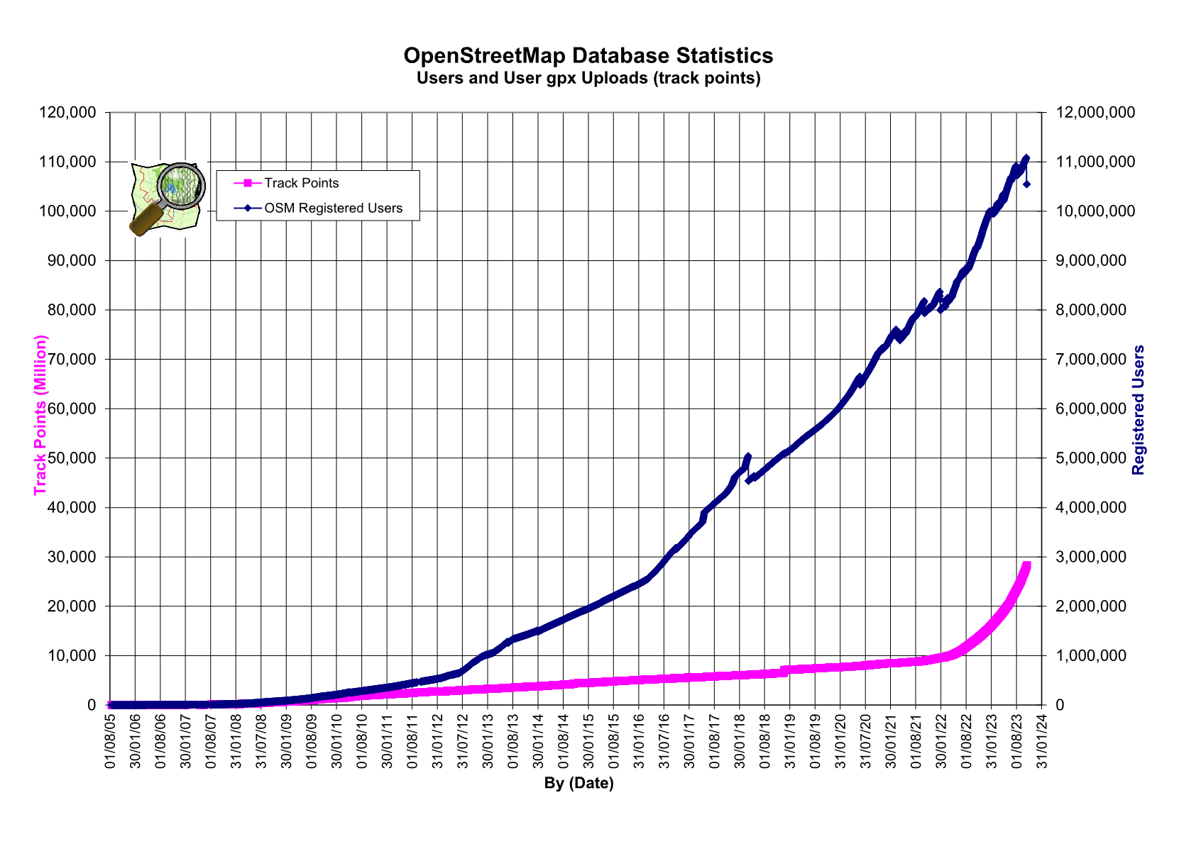
Hello Andy, I have a question about graph on http://wiki.openstreetmap.org/images/9/91/Osmdbstats1.png. Why was the pink line suddenly going to 0 on 14/05/07 ? Thanks! Getsil 18:42, 20 December 2008 (UTC) Sysadmins accidentally dropped the GPX data table at the time and it took a while to recreate from backup. blackadder 13:48, 23 December 2008 (UTC)
NCN milepost disambiguation
Hi Andy! Would you mind disambiguating the two Rowe mileposts on NCR4/45 at Marlborough (MP95 & MP113)? Cheers. --Gregoryw 12:47, 10 June 2009 (UTC)
- The northernmost one is MP95 and the southern one MP113. blackadder 12:36, 11 June 2009 (UTC)
exponential scaling for database statistics
Beeing a physicist I'd love to see an exponential scaling of the number of registered users and track points on Stats. From an exponentially scaled graph one can easily read whether OSM grows exponentially (= graph becomes a straight line) or not. From a linear scaling you can - more or less - just guess.
- I don't think its exponential. Rather it seems to go up in a series of linear jumps. When I next do a stats graphs update I'll take a look at how it looks exponentially. blackadder 14:52, 23 July 2009 (UTC)
Updates for feature stats
Hi, would it make lot of work to update Image:Basic-stats.png? Please :) --!i! 19:54, 17 August 2010 (BST)
- I don't have the data for that. The Sysadmins team or someone else running a planet dump database would need to be asked. blackadder 14:52, 27 September 2010 (BST)
Pre 1922 maps
Hi, I was wondering if alongside the ongoing efforts being made in respect of NPE/7th Series, there was an effort made to try and get pre 1922 OS mapping (esp 1 inch to the mile) scanned in some form as a longer term project.
The reason, is so that those mapping older railway lines (and former station locations), are able to make use of a 'primary' mapping source directly to confirm pre-grouping names, as opposed to secondary or modern collated sources like Wikipedia.
An alternative would be for someone to check what the status of various Railway companies own maps (up to and including the BTC) is, as there appears to be some ambiguity surrounding these.
ShakespeareFan00 10:39, 31 August 2010 (BST)
- Im not aware of anyone working on an older set. blackadder 14:52, 27 September 2010 (BST)
- SABRE Maps (sorry about the plug) might be of interest, particularly the "Popular" and "1923 MOT Half Inch" series. The latter, although published that year, is derived of base maps done about 20 years earlier and includes contemporary names of railway companies on each line. --Ritchie333 00:08, 5 October 2010 (BST)
1:25,000 Coverage
Hi. I have found a 1948 copy of sheet 61/04 (Ashford) which doesn't appear to be on OSM at the moment and generated tiles for it. Would you like them? --Ritchie333 00:08, 5 October 2010 (BST)
shading File:Osmdbstats4A.png
hi, when you look at the file File:Osmdbstats4A.png you see that summer months (in the northern half of the world) are more active than winter months. I wonder if it would be better visible when you use a background pattern: use red background for the summer months, yellow for spring and autumn and white for winter months. I was just wondering it, if it's not a lot of work to do, it might be clearer to see where the bumps come from.
- I need to revise the format soon as the x axis space for dates is running out. I'll have a look at your request then. blackadder 22:30, 30 November 2010 (UTC)
Google map maker page
I've moved your wiki page 'Leading the way' to the more findable linkable title 'Google map maker' and done a bit of work on it. I sense that this may become a more important page as GMM takes hold in the U.S. -- Harry Wood 17:10, 29 June 2011 (BST)
User access stats (daily traffic/user)
Hi Andy!
Great work here on OSM. I wonder if there is any stat that helps me figure out how much traffic (KByte) and how many tiles a unique user per day generates by accessing the main map on average? As our company is currently evaluating the bandwidth need for a major public map service in Germany, I would be highly pleased if you could point out some hints.
Thanks a lot Thomas
Sorry, can't help with that. Best bet would be to post a question on the dev ,ailing list or chat with the sysadmins folks on the #osm-dev IRC channel.
Cheers Andy blackadder 10:20, 25 July 2011 (BST)
Thanks for the update Andy!
Will give IRC and the mailing list a try.
Cheers mate
Thomas
"New" mileposts in Peterborough
Hi Blackadder, I've just added two MPs in Peterborough: no ref, and apparently not in Sustrans db. I can't see how to upload pics, but I'm sure I'll figure that out soon enough.
I've been asked by Sustrans to compile a paper-based inventory/GIS of Peterborough mileposts: would be great to discuss with you if you're still active on the map. Message me here or on my talk page or to eteb3 (no caps) in the map. eteb3 (talk) 18:19, 27 October 2019 (UTC)
image
Are you author of image https://wiki.openstreetmap.org/wiki/File:20080615_LondonToBrightonBikeRide2008_157.jpg https://wiki.openstreetmap.org/wiki/File:IMG_5278_Med.jpg https://wiki.openstreetmap.org/wiki/File:Bcc_517.jpg https://wiki.openstreetmap.org/wiki/File:Bcc_516.jpg https://wiki.openstreetmap.org/wiki/File:Bcc_515.jpg and other where the same bicycle appears ?
Or is it copied from some other place (which one?)?
Would you agree to open licensing of this image, allowing its use by anyone (similarly to your OSM edits)?
Would you be OK with https://wiki.openstreetmap.org/wiki/Template:CC0 (it allows use without attribution or any other requirement) ?
Or do you prefer to require attribution and some other things using https://wiki.openstreetmap.org/wiki/Template:CC-BY-SA-4.0 ?
Mateusz Konieczny (talk) 19:58, 14 April 2021 (UTC)
- I have Blackadder on facebook, so I have pointed him at this. He's got quite a few photos on here which I'd consider to be valuable records of early OpenStreetMap history. Hopefully we can get an open license on them! -- Harry Wood (talk) 13:13, 24 March 2022 (UTC)
- Oh, that is great! Thanks for doing this! (if that succeeds , then https://wiki.openstreetmap.org/w/index.php?title=Birmingham/Bicycle_Parking&diff=prev&oldid=2297600 https://wiki.openstreetmap.org/w/index.php?title=London_to_Brighton_Bike_Ride&diff=prev&oldid=2297601 should be reverted Mateusz Konieczny (talk) 14:29, 24 March 2022 (UTC)
Missing file information
Hello! And thanks for your upload - but some extra info is necessary.
Sorry for bothering you about this, but it is important to know source of the uploaded files.
Are you the author of image File:Bcc109.jpg ?
Or is it copied from some other place (which one?)?
Please, add this info to the file page - something like "I took this photo" or "downloaded from -website link-" or "I took this screeshot of program XYZ".
In case that you are the author of the image: Would you agree to open licensing of this image, allowing its use by anyone (similarly to your OSM edits)?
Would you be OK with CC0 (it allows use without attribution or any other requirement)?
Or do you prefer to require attribution and some other things using CC-BY-SA-4.0?
If you are the author: Please add {{CC0-self}} to the file page to publish the image under CC0 license.
You can also use {{CC-BY-SA-4.0-self}} to publish under CC-BY-SA-4.0 license.
Note that in cases where photo is a screenshot of some software interface: usually it is needed to handle also copyright of software itself.
Note that in cases where aerial imagery is present: also licensing of an aerial imagery matter.
Feel free to ask for help if you need it - you can do it for example by asking on Talk:Wiki: new topic.
Please ask there if you are not sure what is the proper next step. Especially when you are uploading files that are not your own work or are derivative work (screenshots, composition of images, using aerial imagery etc).
Once you add missing data - please remove {{Unknown|subcategory=uploader notified January 2022}} from the file page.
--Mateusz Konieczny (talk) 16:28, 26 January 2022 (UTC)
Missing file information
Hello! And thanks for your upload - but some extra info is necessary.
Sorry for bothering you about this, but it is important to know source of the uploaded files.
Are you the creator of image File:Blackcountry1.png ?
Or is it copied from some other place (which one?)?
Please, add this info to the file page - something like "I took this photo" or "downloaded from -website link-" or "I took this screeshot of program XYZ" or "this is map generated from OpenStreetMap data and SRTM data" or "map generated from OSM data and only OSM data" or "This is my work based on file -link-to-page-with-that-file-and-its-licensing-info-" or "used file downloaded from internet to create it, no idea which one".
Doing this would be already very useful.
Licensing - photos
In case that you are the author of the image: Would you agree to open licensing of this image, allowing its use by anyone (similarly to your OSM edits)?
In case where it is a photo you (except relatively rare cases) author can make it available under a specific free license.
Would you be OK with CC0 (it allows use without attribution or any other requirement)?
Or do you prefer to require attribution and some other things using CC-BY-SA-4.0?
If you are the author: Please add {{CC0-self}} to the file page to publish the image under CC0 license.
You can also use {{CC-BY-SA-4.0-self}} to publish under CC-BY-SA-4.0 license.
Once you add missing data - please remove {{Unknown|subcategory=uploader notified March 2022}} from the file page.
Licensing - other images
If it is not a photo situation gets a bit more complicated.
See Drafts/Media file license chart that may help.
note: if you took screenshot of program made by someone else, screenshot of OSM editor with aerial imagery: then licensing of that elements also matter and you are not a sole author.
note: If you downloaded image made by someone else then you are NOT the author.
Note that in cases where photo is a screenshot of some software interface: usually it is needed to handle also copyright of software itself.
Note that in cases where aerial imagery is present: also licensing of an aerial imagery matter.
Help
Feel free to ask for help if you need it - you can do it for example by asking on Talk:Wiki: new topic.
Please ask there if you are not sure what is the proper next step. Especially when you are uploading files that are not your own work or are derivative work (screenshots, composition of images, using aerial imagery etc).
If you are interested in wider discussion about handling licencing at OSM Wiki, see this thread.
(sorry if I missed something that already states license and source: I am looking through over 20 000 files and fixing obvious cases on my own, in other I ask people who upladed files, but it is possible that I missed something - in such case also please answer)
--Mateusz Konieczny (talk) 13:36, 23 March 2022 (UTC)
Attribution
Hello! And sorry for bothering you, but descriptions of files you uploaded need to be improved.
You have uploaded files which are licensed as requiring attribution. But right now attribution is not specified properly.
Please, ask for help if something is confusing or unclear in this message.
Please, fix that problem with this uploads - note that images with unclear licensing situation may be deleted.
Attribution may be missing completely or just be specified in nonstandard way, in either case it needs to be improved. Note that using CC-BY files without specifying attribution is a copyright violation, which is often unethical and unwanted. So clearly specifying required attribution is needed if license which makes attribution mandatory was used.
If it is applying to your own work which not based on work by others - then you can select own user name or some other preferred attribution or even change license to for example {{CC0-self}}
For your own work: ensure that it is clearly stated at file page that you created image/took the photo/etc
For works by others - please ensure that there is link to the original source which confirms license and that you used proper attribution, or that source is clearly stated in some other way.
Especially for old OSM-baded maps, made from data before license change on 12 September 2012 you should use "map data © OpenStreetMap contributors" as at least part of attribution
For old OSM Carto maps, which predate license change on 12 September 2012 you can use a special template {{OSM Carto screenshot||old_license}}
Missing file information
Hello! And thanks for your upload - but some extra info is necessary.
Sorry for bothering you about this, but it is important to know source of the uploaded files.
Are you the creator of image File:Acer-n35.jpg ?
Or is it copied from some other place (which one?)?
Please, add this info to the file page - something like "I took this photo" or "downloaded from -website link-" or "I took this screeshot of program XYZ" or "this is map generated from OpenStreetMap data and SRTM data" or "map generated from OSM data and only OSM data" or "This is my work based on file -link-to-page-with-that-file-and-its-licensing-info-" or "used file downloaded from internet to create it, no idea which one".
Doing this would be already very useful.
Licensing - photos
In case that you are the author of the image: Would you agree to open licensing of this image, allowing its use by anyone (similarly to your OSM edits)?
In case where it is a photo you (except relatively rare cases) author can make it available under a specific free license.
Would you be OK with CC0 (it allows use without attribution or any other requirement)?
Or do you prefer to require attribution and some other things using CC-BY-SA-4.0?
If you are the author: Please add {{CC0-self}} to the file page to publish the image under CC0 license.
You can also use {{CC-BY-SA-4.0-self|Blackadder}} to publish under CC-BY-SA-4.0 license.
Once you add missing data - please remove {{Unknown|subcategory=uploader notified 2022, May}} from the file page.
Licensing - other images
If it is not a photo situation gets a bit more complicated.
See Drafts/Media file license chart that may help.
note: if you took screenshot of program made by someone else, screenshot of OSM editor with aerial imagery: then licensing of that elements also matter and you are not a sole author.
note: If you downloaded image made by someone else then you are NOT the author.
Note that in cases where photo is a screenshot of some software interface: usually it is needed to handle also copyright of software itself.
Note that in cases where aerial imagery is present: also licensing of an aerial imagery matter.
Help
Feel free to ask for help if you need it - you can do it for example by asking on Talk:Wiki: new topic.
Please ask there if you are not sure what is the proper next step. Especially when you are uploading files that are not your own work or are derivative work (screenshots, composition of images, using aerial imagery etc).
If you are interested in wider discussion about handling licencing at OSM Wiki, see this thread.
(sorry if I missed something that already states license and source: I am looking through over 20 000 files and fixing obvious cases on my own, in other I ask people who upladed files, but it is possible that I missed something - in such case also please answer)
--Mateusz Konieczny (talk) 17:56, 30 May 2022 (UTC)
Missing file information
Hello! And thanks for your upload - but some extra info is necessary.
Sorry for bothering you about this, but it is important to know source of the uploaded files.
Are you the creator of image File:Munchchester-inner.png ?
Or is it copied from some other place (which one?)?
Please, add this info to the file page - something like "I took this photo" or "downloaded from -website link-" or "I took this screeshot of program XYZ" or "this is map generated from OpenStreetMap data and SRTM data" or "map generated from OSM data and only OSM data" or "This is my work based on file -link-to-page-with-that-file-and-its-licensing-info-" or "used file downloaded from internet to create it, no idea which one".
Doing this would be already very useful.
Licensing - photos
In case that you are the author of the image: Would you agree to open licensing of this image, allowing its use by anyone (similarly to your OSM edits)?
In case where it is a photo you have taken then you can make it available under a specific free license (except some cases, like photos of modern sculptures in coutries without freedom of panorama or taking photo of copyrighted artwork).
Would you be OK with CC0 (it allows use without attribution or any other requirement)?
Or do you prefer to require attribution and some other things using CC-BY-SA-4.0?
If you are the author: Please add {{CC0-self}} to the file page to publish the image under CC0 license.
You can also use {{CC-BY-SA-4.0-self|Blackadder}} to publish under CC-BY-SA-4.0 license.
Once you add missing data - please remove {{Unknown|subcategory=uploader notified 2022, August}} from the file page.
Licensing - other images
If it is not a photo situation gets a bit more complicated.
See Drafts/Media file license chart that may help.
note: if you took screenshot of program made by someone else, screenshot of OSM editor with aerial imagery: then licensing of that elements also matter and you are not a sole author.
note: If you downloaded image made by someone else then you are NOT the author.
Note that in cases where photo is a screenshot of some software interface: usually it is needed to handle also copyright of software itself.
Note that in cases where aerial imagery is present: also licensing of an aerial imagery matter.
Help
Feel free to ask for help if you need it - you can do it for example by asking on Talk:Wiki: new topic.
Please ask there if you are not sure what is the proper next step. Especially when you are uploading files that are not your own work or are derivative work (screenshots, composition of images, using aerial imagery etc).
If you are interested in wider discussion about handling licencing at OSM Wiki, see this thread.
(sorry if I missed something that already states license and source: I am looking through over 20 000 files and fixing obvious cases on my own, in other I ask people who upladed files, but it is possible that I missed something - in such case also please answer)
--Mateusz Konieczny (talk) 15:34, 1 August 2022 (UTC)
Missing file information
Hello! And thanks for your upload - but some extra info is necessary.
Sorry for bothering you about this, but it is important to know source of the uploaded files.
Are you the creator of image File:Manchester-inner-6inch.png ?
Or is it copied from some other place (which one?)?
Please, add this info to the file page - something like "I took this photo" or "downloaded from -website link-" or "I took this screeshot of program XYZ" or "this is map generated from OpenStreetMap data and SRTM data" or "map generated from OSM data and only OSM data" or "This is my work based on file -link-to-page-with-that-file-and-its-licensing-info-" or "used file downloaded from internet to create it, no idea which one".
Doing this would be already very useful.
Licensing - photos
In case that you are the author of the image: Would you agree to open licensing of this image, allowing its use by anyone (similarly to your OSM edits)?
In case where it is a photo you have taken then you can make it available under a specific free license (except some cases, like photos of modern sculptures in coutries without freedom of panorama or taking photo of copyrighted artwork).
Would you be OK with CC0 (it allows use without attribution or any other requirement)?
Or do you prefer to require attribution and some other things using CC-BY-SA-4.0?
If you are the author: Please add {{CC0-self}} to the file page to publish the image under CC0 license.
You can also use {{CC-BY-SA-4.0-self|Blackadder}} to publish under CC-BY-SA-4.0 license.
Once you add missing data - please remove {{Unknown|subcategory=uploader notified 2022, August}} from the file page.
Licensing - other images
If it is not a photo situation gets a bit more complicated.
See Drafts/Media file license chart that may help.
note: if you took screenshot of program made by someone else, screenshot of OSM editor with aerial imagery: then licensing of that elements also matter and you are not a sole author.
note: If you downloaded image made by someone else then you are NOT the author.
Note that in cases where photo is a screenshot of some software interface: usually it is needed to handle also copyright of software itself.
Note that in cases where aerial imagery is present: also licensing of an aerial imagery matter.
Help
Feel free to ask for help if you need it - you can do it for example by asking on Talk:Wiki: new topic.
Please ask there if you are not sure what is the proper next step. Especially when you are uploading files that are not your own work or are derivative work (screenshots, composition of images, using aerial imagery etc).
If you are interested in wider discussion about handling licencing at OSM Wiki, see this thread.
(sorry if I missed something that already states license and source: I am looking through over 20 000 files and fixing obvious cases on my own, in other I ask people who upladed files, but it is possible that I missed something - in such case also please answer)
--Mateusz Konieczny (talk) 21:56, 29 August 2022 (UTC)
Missing file information
Hello! And thanks for your upload - but some extra info is necessary.
Sorry for bothering you about this, but it is important to know source of the uploaded files.
Are you the creator of image File:ETrexLegend onbike.png ?
Or is it copied from some other place (which one?)?
Please, add this info to the file page - something like "I took this photo" or "downloaded from -website link-" or "I took this screeshot of program XYZ" or "this is map generated from OpenStreetMap data and SRTM data" or "map generated from OSM data and only OSM data" or "This is my work based on file -link-to-page-with-that-file-and-its-licensing-info-" or "used file downloaded from internet to create it, no idea which one".
Doing this would be already very useful.
Licensing - photos
In case that you are the author of the image: Would you agree to open licensing of this image, allowing its use by anyone (similarly to your OSM edits)?
In case where it is a photo you have taken then you can make it available under a specific free license (except some cases, like photos of modern sculptures in coutries without freedom of panorama or taking photo of copyrighted artwork).
Would you be OK with CC0 (it allows use without attribution or any other requirement)?
Or do you prefer to require attribution and some other things using CC-BY-SA-4.0?
If you are the author: Please add {{CC0-self}} to the file page to publish the image under CC0 license.
You can also use {{CC-BY-SA-4.0-self|Blackadder}} to publish under CC-BY-SA-4.0 license.
Once you add missing data - please remove {{Unknown|subcategory=uploader notified 2022, September}} from the file page.
Licensing - other images
If it is not a photo situation gets a bit more complicated.
See Drafts/Media file license chart that may help.
note: if you took screenshot of program made by someone else, screenshot of OSM editor with aerial imagery: then licensing of that elements also matter and you are not a sole author.
note: If you downloaded image made by someone else then you are NOT the author.
Note that in cases where photo is a screenshot of some software interface: usually it is needed to handle also copyright of software itself.
Note that in cases where aerial imagery is present: also licensing of an aerial imagery matter.
Help
Feel free to ask for help if you need it - you can do it for example by asking on Talk:Wiki: new topic.
Please ask there if you are not sure what is the proper next step. Especially when you are uploading files that are not your own work or are derivative work (screenshots, composition of images, using aerial imagery etc).
If you are interested in wider discussion about handling licencing at OSM Wiki, see this thread.
(sorry if I missed something that already states license and source: I am looking through over 20 000 files and fixing obvious cases on my own, in other I ask people who upladed files, but it is possible that I missed something - in such case also please answer)
--Mateusz Konieczny (talk) 00:40, 22 September 2022 (UTC)
Missing file information
Hello! And thanks for your upload - but some extra info is necessary.
Sorry for bothering you about this, but it is important to know source of the uploaded files.
Are you the creator of image File:Bcc130.jpg ?
Or is it copied from some other place (which one?)?
Please, add this info to the file page - something like "I took this photo" or "downloaded from -website link-" or "I took this screeshot of program XYZ" or "this is map generated from OpenStreetMap data and SRTM data" or "map generated from OSM data and only OSM data" or "This is my work based on file -link-to-page-with-that-file-and-its-licensing-info-" or "used file downloaded from internet to create it, no idea which one".
Doing this would be already very useful.
Licensing - photos
In case that you are the author of the image: Would you agree to open licensing of this image, allowing its use by anyone (similarly to your OSM edits)?
In case where it is a photo you have taken then you can make it available under a specific free license (except some cases, like photos of modern sculptures in coutries without freedom of panorama or taking photo of copyrighted artwork).
Would you be OK with CC0 (it allows use without attribution or any other requirement)?
Or do you prefer to require attribution and some other things using CC-BY-SA-4.0?
If you are the author: Please add {{CC0-self}} to the file page to publish the image under CC0 license.
You can also use {{CC-BY-SA-4.0-self|Blackadder}} to publish under CC-BY-SA-4.0 license.
Once you add missing data - please remove {{Unknown|subcategory=uploader notified 2022, November}} from the file page.
Licensing - other images
If it is not a photo situation gets a bit more complicated.
See Drafts/Media file license chart that may help.
note: if you took screenshot of program made by someone else, screenshot of OSM editor with aerial imagery: then licensing of that elements also matter and you are not a sole author.
note: If you downloaded image made by someone else then you are NOT the author.
Note that in cases where photo is a screenshot of some software interface: usually it is needed to handle also copyright of software itself.
Note that in cases where aerial imagery is present: also licensing of an aerial imagery matter.
Help
Feel free to ask for help if you need it - you can do it for example by asking on Talk:Wiki: new topic.
Please ask there if you are not sure what is the proper next step. Especially when you are uploading files that are not your own work or are derivative work (screenshots, composition of images, using aerial imagery etc).
If you are interested in wider discussion about handling licencing at OSM Wiki, see this thread.
(sorry if I missed something that already states license and source: I am looking through over 20 000 files and fixing obvious cases on my own, in other I ask people who upladed files, but it is possible that I missed something - in such case also please answer)
--Mateusz Konieczny (talk) 18:13, 30 November 2022 (UTC)
Missing file information
Hello! And thanks for your upload - but some extra info is necessary.
Sorry for bothering you about this, but it is important to know source of the uploaded files.
Are you the creator of image File:ETrex back.png ?
Or is it copied from some other place (which one?)?
Please, add this info to the file page - something like "I took this photo" or "downloaded from -website link-" or "I took this screeshot of program XYZ" or "this is map generated from OpenStreetMap data and SRTM data" or "map generated from OSM data and only OSM data" or "This is my work based on file -link-to-page-with-that-file-and-its-licensing-info-" or "used file downloaded from internet to create it, no idea which one".
Doing this would be already very useful.
Licensing - photos
In case that you are the author of the image: Would you agree to open licensing of this image, allowing its use by anyone (similarly to your OSM edits)?
In case where it is a photo you have taken then you can make it available under a specific free license (except some cases, like photos of modern sculptures in coutries without freedom of panorama or taking photo of copyrighted artwork).
Would you be OK with CC0 (it allows use without attribution or any other requirement)?
Or do you prefer to require attribution and some other things using CC-BY-SA-4.0?
If you are the author: Please add {{CC0-self}} to the file page to publish the image under CC0 license.
You can also use {{CC-BY-SA-4.0-self|Blackadder}} to publish under CC-BY-SA-4.0 license.
Once you add missing data - please remove {{Unknown|subcategory=uploader notified 2022, December}} from the file page.
Licensing - other images
If it is not a photo situation gets a bit more complicated.
See Drafts/Media file license chart that may help.
note: if you took screenshot of program made by someone else, screenshot of OSM editor with aerial imagery: then licensing of that elements also matter and you are not a sole author.
note: If you downloaded image made by someone else then you are NOT the author.
Note that in cases where photo is a screenshot of some software interface: usually it is needed to handle also copyright of software itself.
Note that in cases where aerial imagery is present: also licensing of an aerial imagery matter.
Help
Feel free to ask for help if you need it - you can do it for example by asking on Talk:Wiki: new topic.
Please ask there if you are not sure what is the proper next step. Especially when you are uploading files that are not your own work or are derivative work (screenshots, composition of images, using aerial imagery etc).
If you are interested in wider discussion about handling licencing at OSM Wiki, see this thread.
(sorry if I missed something that already states license and source: I am looking through over 20 000 files and fixing obvious cases on my own, in other I ask people who upladed files, but it is possible that I missed something - in such case also please answer)
--Mateusz Konieczny (talk) 10:14, 29 December 2022 (UTC)