ViaAlpina
The Via Alpina is a network of five long-distance hiking trails across the alpine regions of Slovenia, Austria, Germany, Liechtenstein, Switzerland, Italy, France, and Monaco. There are 342 stages and over 5000km between 0 to 3000m above sea level.[1]
The project was created by a group of public and private organisations from the 8 Alpine countries in 2000, receiving EU funding from 2001 until 2008. The international secretariat is hosted by the Association Grande Traversée des Alpes in Grenoble and there are national secretariats (hosted by public administrations or hiking associations) in each country. Its aim is to support sustainable development in remote mountain areas and promote the Alpine cultures and cultural exchanges.[2]
How to map
Below are (very draft) guidelines on how to have a coherent tagging and organisation of relations on the 5 routes of the Via Alpina. (Do not hesitate to discuss it in the Discussion page and to improve this page). Originally based on Mayeul commenting this: https://www.openstreetmap.org/browse/relation/2632354
A major reference is: https://wiki.openstreetmap.org/wiki/Walking_Routes
Hierarchy of relations
Currently, the Via Alpina is already split into three levels. This may seem a bit confusing at first, but works very efficient. The reference map http://hiking.waymarkedtrails.org knows exactly what to do. At each level, slightly different tags will provide full information.
Top level
- Via Alpina
type = superroute
route = hiking
name = Via Alpina
network = iwn
operator = via-alpina.org
description = Hiking route from Trieste to Monaco
symbol = Two curves form an uppercase V in front of an A-shaped gray triangle)
symbol:de = Zwei den Buchstaben "V" formende Bögen vor einem Dreieck in A-Form
symbol:it = Due curve fanno una V maiusculo di fronte ad un triangolo grigio a forma di A
symbol:fr = Deux courbes font un V majuscule devant un triangle gris en forme de A

osmc:symbol = black:red:white_triangle:V:blue
Second level
 - Via Alpina Red
 - Via Alpina Blue
 - Via Alpina Purple
 - Via Alpina Yellow
 - Via Alpina Green
type = superroute
route = hiking
name = Via Alpina Red
name:de = Via Alpina Rot
name:fr = Via Alpina Rouge
name:it = Via Alpina Rosso
network = iwn
operator = via-alpina.org
description = Stages R1 - R161, Trieste - Monaco
symbol = Two curves form an uppercase V in front of an A-shaped gray triangle
etc.
osmc:symbol = black:red:white_triangle:V:blue
Third level
   - Via Alpina Red R161
   - Via Alpina Blue D1
   - Via Alpina Purple A1
   - Via Alpina Yellow B1
   - Via Alpina Green C1
   - etc.
type = route
route = hiking
name = Via Alpina Red R161
operator = via-alpina.org
network = iwn
description = Peillon - Monaco - Place du Palais
website=http://www.via-alpina.org/en/stage/341
ref = VA-R161
symbol: Do not specify on this level
osmc:symbol: Do not specify on this level
Fourth level
This is used for two reasons. One is that a hiking route can be used for several marked footpaths. For instance both Via Alpina and Alta Via dei Monti Liguri. The second reason is to add alternative routes to a stage, for instance access path to hut, alternative in bad weather, etc.
     - (xxxxxx)
       This means that the relation has no name. Instead, put a note for mappers: Part of Via Alpina Red R161
type = route
route = hiking
note = Part of Via Alpina Red R161
operator = via-alpina.org
network = iwn
description = Alternative ... - ...
--Traildino 19:20, 17 December 2012 (UTC)
symbol
osmc:symbol = black:red:white_triangle:V:blue
ref
ref=VA-R157 As seen at: http://www.via-alpina.org/en/stage/337 Beware, BLUE is "D", yellow is "B"... Purple is "A" so I think the following is wrong: https://www.openstreetmap.org/browse/relation/1665395 (Wrong letter should be fixed now Abi12563 21.12.2012)
I'm not 100% satisfied with this, but the fact is that there is no widely common known ref. system for the VA. While if you say "GR20" to any casual hiker in France, they know it's in Corsica (there was even a large fiction movie about it). So we somehow need to choose ourselves what is the best, and it is how the Via ALpina organisation calls it. Mayeul 17:33, 17 December 2012 (UTC)
hyperlink
https://wiki.openstreetmap.org/wiki/Key:website website=http://www.via-alpina.org/en/stage/337 In addition to being useful to the users, whatever the language code ("en") we use, this gives us an "id" which may be useful for systematic/automatic editing in the future. Mayeul 17:33, 17 December 2012 (UTC)
note and description
On this: https://www.openstreetmap.org/browse/relation/2634991 instead of note=Part of Via Alpina Itinéraire Rouge I would stick to a single language in the "note". Mayeul 17:33, 17 December 2012 (UTC) You might want to use: "description" for that instead (which is meant for users, while "note" is for fellow mapers) But the relation already says it. Mayeul 17:33, 17 December 2012 (UTC)
Description is useful for levels 1 - 3. Note is useful for level 4, because this level has no name. --Traildino 19:43, 17 December 2012 (UTC)
name
Not sure the words "Via Alpina" should be repeated at all levels (all relations/ways); probably it is somehow useful, it would be good to know exactly when. Mayeul 17:33, 17 December 2012 (UTC)
legal
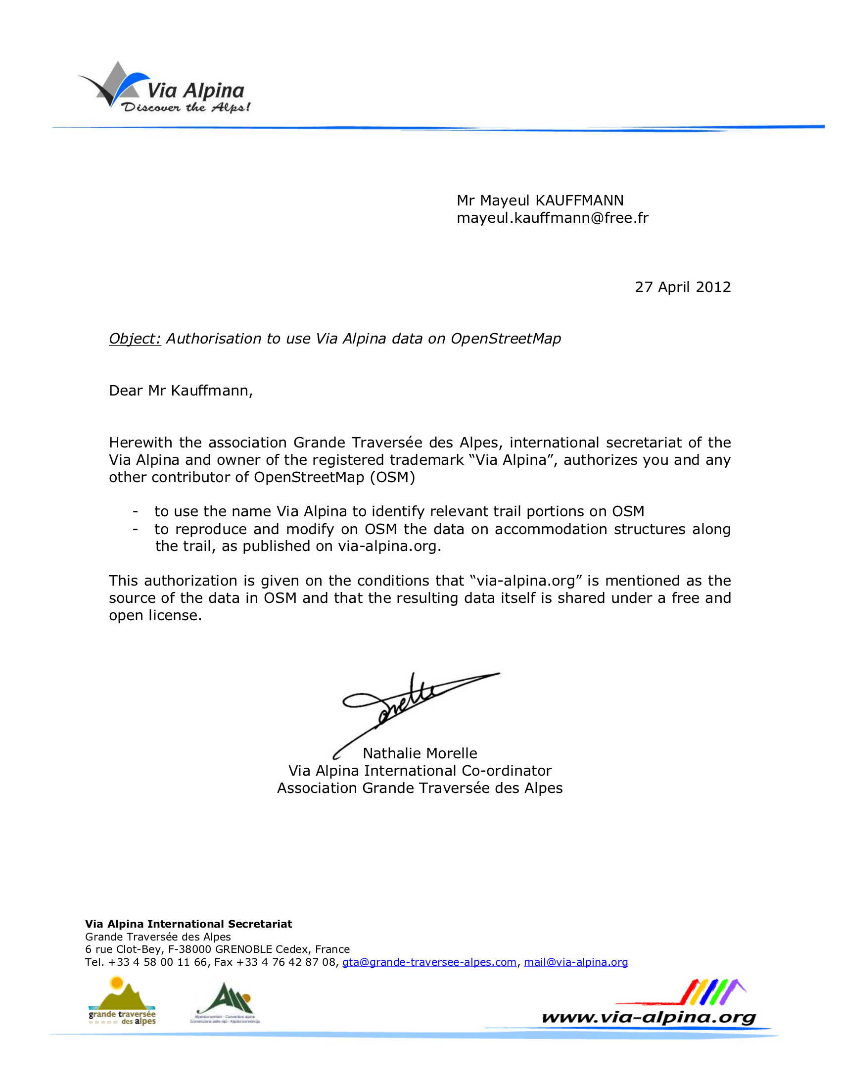
In addition to the letter the Via Alpina organisation wrote (https://wiki.openstreetmap.org/w/images/9/98/Authorisation_ViaAlpina_OSM_accomodation.png) they assure us via email that the tagging proposal is okay: "I [N. Morelle, Via Alpina International Co-ordinator] had a look at the link below [link to this page] and I can’t see any problem with it. The hierarchy seems logical to me and yes of course the OSM community is allowed to use the stage reference numbers (R161, A23 etc.) as well as the “Via Alpina” name. No problem either in using the name of the start and end locations, which is purely factual, we claim no ownership on that!". (--Traildino 22:26, 9 January 2013 (UTC))
A looooong mapping party!
Around the Alps in 80 days

During Summer 2012, a group of hikers from 4 countries (among which some members of Alpine clubs) contributed to the OpenStreetMap project in quite a particular fashion, hiking in the Western Alps, collecting GPS tracks, taking geotagged pictures and inserting the data into the OpenStreetMap database in order to produce a detailed map of the trails.
Want to know more? See the map? Visit our site here: http://www.outdoormaps.org
Are you interested? Contact us! (send a message to Mayeul)
Via Alpina Red
superroute: https://www.openstreetmap.org/relation/1665395
| ref | link route | date check | % progress | source | note |
|---|---|---|---|---|---|
| VA-R1 | 2925532 |
03 april 2018 | 100 % | http://www.via-alpina.org/en/stage/181 | |
| VA-R2 | 2929190 |
03 april 2018 | 100 % | http://www.via-alpina.org/en/stage/182 | |
| VA-R3 | 2931231 |
03 april 2018 | 100 % | http://www.via-alpina.org/en/stage/183 | |
| VA-R4 | 3360417 |
03 april 2018 | 100 % | http://www.via-alpina.org/en/stage/184 | |
| VA-R5 | 3360511 |
03 april 2018 | 100 % | http://www.via-alpina.org/en/stage/185 | |
| VA-R6 | 3360594 |
03 april 2018 | 100 % | http://www.via-alpina.org/en/stage/186 | |
| VA-R7 | 3360813 |
03 april 2018 | 100 % | http://www.via-alpina.org/en/stage/187 | |
| VA-R8 | 8169858 |
03 april 2018 | 100 % | http://www.via-alpina.org/en/stage/188 | |
| VA-R9 | 8169884 |
03 april 2018 | 100 % | http://www.via-alpina.org/en/stage/189 | |
| VA-R10a | 8172282 |
03 april 2018 | 100 % | http://www.via-alpina.org/en/stage/190 | |
| VA-R10b | 8172325 |
03 april 2018 | 100 % | http://www.via-alpina.org/en/stage/349 | |
| VA-R11 | 8172881 |
03 april 2018 | 100 % | http://www.via-alpina.org/en/stage/191 | |
| VA-R12 | 8172923 |
03 april 2018 | 100 % | http://www.via-alpina.org/en/stage/192 | |
| VA-R13 | 8173000 |
03 april 2018 | 100 % | http://www.via-alpina.org/en/stage/193 | |
| VA-R14 | 8173489 |
03 april 2018 | 100 % | http://www.via-alpina.org/en/stage/194 | |
| VA-R15 | 2716464 |
04 april 2018 | 100 % | http://www.via-alpina.org/en/stage/195 | |
| VA-R16 | 4782753 |
04 april 2018 | 100 % | http://www.via-alpina.org/en/stage/196 | |
| VA-R17 | 4782787 |
04 april 2018 | 100 % | http://www.via-alpina.org/en/stage/197 | |
| VA-R18 | 4782810 |
04 april 2018 | 100 % | http://www.via-alpina.org/en/stage/198 | |
| VA-R19 | 4782828 |
04 april 2018 | 100 % | http://www.via-alpina.org/en/stage/199 | |
| VA-R20 | http://www.via-alpina.org/en/stage/200 | ||||
| VA-R21 | http://www.via-alpina.org/en/stage/201 | ||||
| VA-R22 | http://www.via-alpina.org/en/stage/202 | ||||
| VA-R23 | http://www.via-alpina.org/en/stage/203 | ||||
| VA-R24 | http://www.via-alpina.org/en/stage/204 | ||||
| VA-R25 | http://www.via-alpina.org/en/stage/205 | ||||
| VA-R26 | http://www.via-alpina.org/en/stage/206 | ||||
| VA-R27 | 2714729 |
04 april 2018 | 100 % | http://www.via-alpina.org/en/stage/207 | |
| VA-R28 | http://www.via-alpina.org/en/stage/208 | ||||
| VA-R29 | http://www.via-alpina.org/en/stage/209 | ||||
| VA-R30 | http://www.via-alpina.org/en/stage/210 | ||||
| VA-R31 | http://www.via-alpina.org/en/stage/211 | ||||
| VA-R32 | http://www.via-alpina.org/en/stage/212 | ||||
| VA-R33 | http://www.via-alpina.org/en/stage/213 | ||||
| VA-R34 | http://www.via-alpina.org/en/stage/214 | ||||
| VA-R35 | http://www.via-alpina.org/en/stage/215 | ||||
| VA-R36 | http://www.via-alpina.org/en/stage/216 | ||||
| VA-R37 | http://www.via-alpina.org/en/stage/217 | ||||
| VA-R38 | http://www.via-alpina.org/en/stage/218 | ||||
| VA-R39 | http://www.via-alpina.org/en/stage/219 | ||||
| VA-R40 | http://www.via-alpina.org/en/stage/220 | ||||
| VA-R41 | http://www.via-alpina.org/en/stage/221 | ||||
| VA-R42 | http://www.via-alpina.org/en/stage/222 | ||||
| VA-R43 | http://www.via-alpina.org/en/stage/223 | ||||
| VA-R44 | http://www.via-alpina.org/en/stage/224 | ||||
| VA-R45 | http://www.via-alpina.org/en/stage/225 | ||||
| VA-R46 | http://www.via-alpina.org/en/stage/226 | ||||
| VA-R47 | http://www.via-alpina.org/en/stage/227 | ||||
| VA-R48 | http://www.via-alpina.org/en/stage/228 | ||||
| VA-R49 | http://www.via-alpina.org/en/stage/229 | ||||
| VA-R50 | http://www.via-alpina.org/en/stage/230 | ||||
| VA-R51 | http://www.via-alpina.org/en/stage/231 | ||||
| VA-R52 | http://www.via-alpina.org/en/stage/232 | ||||
| VA-R53 | http://www.via-alpina.org/en/stage/233 | ||||
| VA-R54 | http://www.via-alpina.org/en/stage/234 | ||||
| VA-R55 | http://www.via-alpina.org/en/stage/235 | ||||
| VA-R56 | http://www.via-alpina.org/en/stage/236 | ||||
| VA-R57 | http://www.via-alpina.org/en/stage/237 | ||||
| VA-R58 | http://www.via-alpina.org/en/stage/238 | ||||
| VA-R59 | http://www.via-alpina.org/en/stage/239 | ||||
| VA-R60 | http://www.via-alpina.org/en/stage/240 | ||||
| VA-R61 | http://www.via-alpina.org/en/stage/241 | ||||
| VA-R62 | http://www.via-alpina.org/en/stage/242 | ||||
| VA-R63 | http://www.via-alpina.org/en/stage/243 | ||||
| VA-R64 | http://www.via-alpina.org/en/stage/244 | ||||
| VA-R65 | http://www.via-alpina.org/en/stage/245 | ||||
| VA-R66 | http://www.via-alpina.org/en/stage/246 | ||||
| VA-R67 | http://www.via-alpina.org/en/stage/247 | ||||
| VA-R68 | http://www.via-alpina.org/en/stage/248 | ||||
| VA-R69 | http://www.via-alpina.org/en/stage/249 | ||||
| VA-R70 | http://www.via-alpina.org/en/stage/250 | ||||
| VA-R71 | http://www.via-alpina.org/en/stage/251 | ||||
| VA-R72 | http://www.via-alpina.org/en/stage/252 | ||||
| VA-R73 | http://www.via-alpina.org/en/stage/253 | ||||
| VA-R74 | http://www.via-alpina.org/en/stage/254 | ||||
| VA-R75 | http://www.via-alpina.org/en/stage/255 | ||||
| VA-R76 | http://www.via-alpina.org/en/stage/256 | ||||
| VA-R77 | http://www.via-alpina.org/en/stage/257 | ||||
| VA-R78 | http://www.via-alpina.org/en/stage/258 | ||||
| VA-R79 | http://www.via-alpina.org/en/stage/259 | ||||
| VA-R80 | http://www.via-alpina.org/en/stage/260 | ||||
| VA-R81 | http://www.via-alpina.org/en/stage/261 | ||||
| VA-R82 | http://www.via-alpina.org/en/stage/262 | ||||
| VA-R83 | http://www.via-alpina.org/en/stage/263 | ||||
| VA-R84 | http://www.via-alpina.org/en/stage/264 | ||||
| VA-R85 | http://www.via-alpina.org/en/stage/265 | ||||
| VA-R86 | http://www.via-alpina.org/en/stage/266 | ||||
| VA-R87 | http://www.via-alpina.org/en/stage/267 | ||||
| VA-R88 | http://www.via-alpina.org/en/stage/268 | ||||
| VA-R89 | http://www.via-alpina.org/en/stage/269 | ||||
| VA-R90 | http://www.via-alpina.org/en/stage/270 | ||||
| VA-R91 | http://www.via-alpina.org/en/stage/271 | ||||
| VA-R92 | http://www.via-alpina.org/en/stage/272 | ||||
| VA-R93 | http://www.via-alpina.org/en/stage/273 | ||||
| VA-R94 | http://www.via-alpina.org/en/stage/274 | ||||
| VA-R95 | http://www.via-alpina.org/en/stage/275 | ||||
| VA-R96 | http://www.via-alpina.org/en/stage/276 | ||||
| VA-R97 | http://www.via-alpina.org/en/stage/277 | ||||
| VA-R98 | http://www.via-alpina.org/en/stage/278 | ||||
| VA-R99 | http://www.via-alpina.org/en/stage/279 | ||||
| VA-R100 | http://www.via-alpina.org/en/stage/280 | ||||
| VA-R101 | http://www.via-alpina.org/en/stage/281 | ||||
| VA-R102 | http://www.via-alpina.org/en/stage/282 | ||||
| VA-R103 | http://www.via-alpina.org/en/stage/283 | ||||
| VA-R104 | http://www.via-alpina.org/en/stage/284 | ||||
| VA-R105 | http://www.via-alpina.org/en/stage/285 | ||||
| VA-R106 | http://www.via-alpina.org/en/stage/286 | ||||
| VA-R107 | http://www.via-alpina.org/en/stage/287 | ||||
| VA-R108 | http://www.via-alpina.org/en/stage/288 | ||||
| VA-R109 | http://www.via-alpina.org/en/stage/289 | ||||
| VA-R110 | http://www.via-alpina.org/en/stage/290 | ||||
| VA-R111 | http://www.via-alpina.org/en/stage/291 | ||||
| VA-R112 | http://www.via-alpina.org/en/stage/292 | ||||
| VA-R113 | http://www.via-alpina.org/en/stage/293 | ||||
| VA-R114 | http://www.via-alpina.org/en/stage/294 | ||||
| VA-R115 | http://www.via-alpina.org/en/stage/295 | ||||
| VA-R116 | http://www.via-alpina.org/en/stage/296 | ||||
| VA-R117 | http://www.via-alpina.org/en/stage/297 | ||||
| VA-R118 | http://www.via-alpina.org/en/stage/298 | ||||
| VA-R119 | http://www.via-alpina.org/en/stage/299 | ||||
| VA-R120 | http://www.via-alpina.org/en/stage/300 | ||||
| VA-R121 | http://www.via-alpina.org/en/stage/301 | ||||
| VA-R122 | http://www.via-alpina.org/en/stage/302 | ||||
| VA-R123 | http://www.via-alpina.org/en/stage/303 | ||||
| VA-R124 | http://www.via-alpina.org/en/stage/304 | ||||
| VA-R125 | http://www.via-alpina.org/en/stage/305 | ||||
| VA-R126 | http://www.via-alpina.org/en/stage/306 | ||||
| VA-R127 | http://www.via-alpina.org/en/stage/307 | ||||
| VA-R128 | http://www.via-alpina.org/en/stage/308 | ||||
| VA-R129 | http://www.via-alpina.org/en/stage/309 | ||||
| VA-R130 | http://www.via-alpina.org/en/stage/310 | ||||
| VA-R131 | http://www.via-alpina.org/en/stage/311 | ||||
| VA-R132 | http://www.via-alpina.org/en/stage/312 | ||||
| VA-R133 | http://www.via-alpina.org/en/stage/313 | ||||
| VA-R134 | http://www.via-alpina.org/en/stage/314 | ||||
| VA-R135 | http://www.via-alpina.org/en/stage/315 | ||||
| VA-R136 | http://www.via-alpina.org/en/stage/316 | ||||
| VA-R137 | http://www.via-alpina.org/en/stage/317 | ||||
| VA-R138 | http://www.via-alpina.org/en/stage/318 | ||||
| VA-R139 | http://www.via-alpina.org/en/stage/319 | ||||
| VA-R140 | http://www.via-alpina.org/en/stage/320 | ||||
| VA-R141 | http://www.via-alpina.org/en/stage/321 | ||||
| VA-R142 | http://www.via-alpina.org/en/stage/322 | ||||
| VA-R143 | http://www.via-alpina.org/en/stage/323 | ||||
| VA-R144 | http://www.via-alpina.org/en/stage/324 | ||||
| VA-R145 | http://www.via-alpina.org/en/stage/325 | ||||
| VA-R146 | http://www.via-alpina.org/en/stage/326 | ||||
| VA-R147 | http://www.via-alpina.org/en/stage/327 | ||||
| VA-R148 | http://www.via-alpina.org/en/stage/328 | ||||
| VA-R149 | http://www.via-alpina.org/en/stage/329 | ||||
| VA-R150 | http://www.via-alpina.org/en/stage/330 | ||||
| VA-R151 | http://www.via-alpina.org/en/stage/331 | ||||
| VA-R152 | http://www.via-alpina.org/en/stage/332 | ||||
| VA-R153 | http://www.via-alpina.org/en/stage/333 | ||||
| VA-R154 | http://www.via-alpina.org/en/stage/334 | ||||
| VA-R155 | http://www.via-alpina.org/en/stage/335 | ||||
| VA-R156 | http://www.via-alpina.org/en/stage/336 | ||||
| VA-R157 | http://www.via-alpina.org/en/stage/337 | ||||
| VA-R158 | http://www.via-alpina.org/en/stage/338 | ||||
| VA-R159 | http://www.via-alpina.org/en/stage/339 | ||||
| VA-R160 | http://www.via-alpina.org/en/stage/340 | ||||
| VA-R161 | http://www.via-alpina.org/en/stage/341 |
Via Alpina Yellow
superroute: https://www.openstreetmap.org/relation/2122176
| ref | link route | date check | % progress | source | note |
|---|---|---|---|---|---|
| VA-B1 | 2925533 |
100 % | http://www.via-alpina.org/en/stage/67 | ||
| VA-B2 | 2925549 |
100 % | http://www.via-alpina.org/en/stage/68 | ||
| VA-B3 | 2925578 |
100 % | http://www.via-alpina.org/en/stage/69 | ||
| VA-B4 | 2925581 |
100 % | http://www.via-alpina.org/en/stage/70 | ||
| VA-B5 | 2969836 |
100 % | http://www.via-alpina.org/en/stage/71 | ||
| VA-B6 | http://www.via-alpina.org/en/stage/72 | ||||
| VA-B7 | http://www.via-alpina.org/en/stage/73 | ||||
| VA-B8 | http://www.via-alpina.org/en/stage/74 | ||||
| VA-B9 | http://www.via-alpina.org/en/stage/75 | ||||
| VA-B10 | http://www.via-alpina.org/en/stage/76 | ||||
| VA-B11 | http://www.via-alpina.org/en/stage/77 | ||||
| VA-B12 | http://www.via-alpina.org/en/stage/78 | ||||
| VA-B13 | http://www.via-alpina.org/en/stage/79 | ||||
| VA-B14 | http://www.via-alpina.org/en/stage/80 | ||||
| VA-B15 | http://www.via-alpina.org/en/stage/81 | ||||
| VA-B16 | http://www.via-alpina.org/en/stage/82 | ||||
| VA-B17 | http://www.via-alpina.org/en/stage/83 | ||||
| VA-B18 | http://www.via-alpina.org/en/stage/84 | ||||
| VA-B19 | http://www.via-alpina.org/en/stage/85 | ||||
| VA-B20 | http://www.via-alpina.org/en/stage/86 | ||||
| VA-B21 | http://www.via-alpina.org/en/stage/87 | ||||
| VA-B22 | http://www.via-alpina.org/en/stage/88 | ||||
| VA-B23 | http://www.via-alpina.org/en/stage/89 | ||||
| VA-B24 | http://www.via-alpina.org/en/stage/90 | ||||
| VA-B25 | http://www.via-alpina.org/en/stage/91 | ||||
| VA-B26 | http://www.via-alpina.org/en/stage/92 | ||||
| VA-B27 | http://www.via-alpina.org/en/stage/93 | ||||
| VA-B28 | http://www.via-alpina.org/en/stage/94 | ||||
| VA-B29 | http://www.via-alpina.org/en/stage/95 | ||||
| VA-B30 | http://www.via-alpina.org/en/stage/96 | ||||
| VA-B31 | http://www.via-alpina.org/en/stage/97 | ||||
| VA-B32 | http://www.via-alpina.org/en/stage/98 | ||||
| VA-B33 | http://www.via-alpina.org/en/stage/99 | ||||
| VA-B34 | http://www.via-alpina.org/en/stage/100 | ||||
| VA-B35 | http://www.via-alpina.org/en/stage/101 | ||||
| VA-B36 | http://www.via-alpina.org/en/stage/102 | ||||
| VA-B37 | http://www.via-alpina.org/en/stage/103 | ||||
| VA-B38 | http://www.via-alpina.org/en/stage/104 | ||||
| VA-B39 | http://www.via-alpina.org/en/stage/105 | ||||
| VA-B40 | 300374 |
http://www.via-alpina.org/en/stage/106 |