WikiProject Bangladesh
| V・T・E |
| latitude: 23.7, longitude: 90.231 |
| Browse map of Bangladesh 23°42′00.00″ N, 90°13′51.60″ E |
| Edit map |
|
External links:
|
| Use this template for your locality |
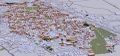
Bangladesh is a country in Southern Asia at latitude 23°42′00.00″ North, longitude 90°13′51.60″ East.

HOT activation for 2017 South Asian Floods
To Know more about Bangladesh
This page contains information relating to mapping activity that is specific to Bangladesh. Any guides or conventions on this page can be discusses on the discussion page, feel free to comment or help (mapping your area, tagging streets or correcting this page).
So far Bangladesh has moderate users, most of them living in Dhaka. Hopefully people will start joining the project in a large number.
History
Syed Ishtiaque Ahmed (1986-), a Lecturer of the Department of Computer Science and Engineering of Bangladesh University of Engineering and technology (BUET), felt the necessity of taking proper initiatives of starting OpenStreetMap in Bangladesh. In July 2010, he attended the annual meeting of OpenStreetMap, called State of the Map (SotM) and presented the "State of Bangladesh". As a part of the scholarship, Ishtiaque got 5 GPS units from the OpenStreetMap Foundation. But it took some time to get those GPS units in Bangladesh.
In January 2011, a working group is being established by Syed Ishtiaque Ahmed in Department of Computer Science and Engineering, Bangladesh University of Engineering and technology (BUET). The OSM Foundation made a generous donation of 5 GPS devices to this working group to kick-start their work. This is likely to mean a change in the pace of progress for the map in Bangladesh.
In March 2011, The Chittagong branch of OSM Bangladesh was formed. Chittagong is the second largest city of Bangladesh. Two young Lecturers of Chittagong University of Engineering and Technology (CUET) took the initiative to form it. They got one of the five GPS units OSM-BD received from OSM Foundation. After that there were no activities of OSM in Bangladesh. Later in the year of 2013, the initiative was revived by The World Bank,Bangladesh(GFDRR,WSP). It was pioneered by The World Bank GIS and Data Management Consultant Ahasanul Hoque. Now open data revolution is getting a new approach in Bangladesh.
Communication
- Mailing List: talk-bd
- Facebook group: OpenStreetMap Bangladesh
- Telegram Group: OpenStreetMap Bangladesh
- OpenStreetMap Community Forum: OpenStreetMap Community Forum Bangladesh
OSM Forum: OpenStreetMap BangladeshNot used anymore.
Tagging conventions
For the time being we are following the usual tagging conventions of OpenStreetMap. We have proposed a Tagging Standard for Bangladesh and we are inviting suggestions on this.
Learning Resources
For self learning of Open Street Map, what is it, how it works, how can you contribute, what are the possibilities; one can check some online resources. Some useful links are given below:
One can also search in Youtube, or can google out so many results. So hope you will enjoy the learning and contribute for the betterment of the world.
Maps
How to participate?
If you have a GPS device:
- upload your tracks and edit them :)
- If you don't have a GPS device then you can use your Smartphone, there are several apps you can use to collect data like OSMAND, GPS Logger Etc.
- You can also use Field Papers to collect data without any GPS or Smartphone.
If you haven't any GPS but are still willing to contribute you can participate in many ways:
- you can enhance this wiki page :)
- you can take contact with other wiki sites (Wikipedia, Banglapedia, Wikitravel, etc.) and provide them with image of already mapped area
- you can inventoried and tag, using Potlatch with Yahoo imagery or using JOSM if it is already in a mapped area, any POI (point of interest). I think here about schools, universities, hospitals, restaurant, tourist sites or attraction, monuments, parks, train station, piers, etc.
- you can start adding the Bangla translation to the tags, city and village names, etc.
- you can add the names to the river. There are so many of them! Often it is necessary to ask the locals for the name of the river.
- you can take contact with some public surveying institutions and ask them about the licensing of their data. Is there any of their geodata that are compatible with the OpenStreetMap opencontent licence?
- You can start mapping bus road or train tracks (using relations) - perhaps take contact with the main coach to ask about their road and their stop?
- you can download all the data from the Bangladesh area (take a while because the rivers takes a lot of place!), and make a .img file (with mkgmap) ready to be uploaded to your Garmin or your phone. You can eventually let people know about where one can access it by mentioning it at this page OSM Map On Garmin/Download
Trainings
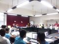
- Two days long OpenStreetMap training (Data For Action Project) at IDMVS , University of Dhaka; Arranged by Dhaka City Red Crescent Unit, (BDRCS) and OSMBD, Dhaka on August 12-13, 2016.OpenStreetMap trainingon August 12-13, 2016
- OpenStreetMap training at YMCA Training center,Savar Dhaka for 20 foreign(UK) and 20 Bangladeshi volunteers to map Durgapur Upazila Netrokona district, Anwara Upazila of Chittagong district and Moksedpur Upazila of Goplaganj District in association with YCARE international and Missing Maps Project, 5 July 2015.
- Five days long OpenStreetMap training and mapping event at Gendaria and Mogbazar Dhaka; Arranged by American RedCrooss and BDRCS, Dhaka on May 14-19, 2015.
- Two days long training of trainers (ToT) on Basics of Mapping, its component and OpenStreetMap for spatial data collection, editing and processing Arranged by Water Sanitation Program(WSP), The World Bank, Dhaka on April 10-11, 2015.
- Facilitated and conducted a day long training and Map-a-thon for Netrokona, Bangladesh on Open Street Map jointly organized by Stanford University-USA and Eastern University-Bangladesh, Dhaka on April 9, 2015.
- A day long training on” OpenStreetMapping for GIS Specialist in Bangladesh” was held at World Bank Bangladesh Office. Organized by Water and Sanitation Program (WSP) and GFDRR; Held at Jamuna Conference Center, World Bank office Dhaka on 27 August 2013.
- Nine days long training on Basic GPS on for spatial data collection and processing Arranged by Logistics Cluster, United Nations World Food Program (WFP), held at Hotel Asia Pacific, Baridhara, Dhaka on March 23-25 and April 1-8, 2015.
- A day long training was provided on GIS data collection by OSM technology OSMAND, JOSM to collect data at field level from Kamrangirchar and Hazaribagh area under MissingMaps Project of London, January 17- 29, 2015.
- A day long training was provided on GIS data collection and management by OSM technology for their development project entitled Strengthening Capacity of BBS in Population and Demographic Data Collection Using GIS held at at Bangladesh Bureau of Statistics, Dhaka on February 28, 2015.
- A day long training was facilitated on OpenStreetMap GeoNoDe and GIS open data Management” at Information Management Working Group workshop held at Six Seasons Hotel Dhaka on February 16-17, 2015.
- Day long training on “GeoNODE-an web based open GIS data sharing platform for Government and Non-government organizations” at Jamuna Conference Center, World Bank Bangladesh on 24 September, 2014.
- Three days long training on “OpenStreetMapping for NGO Volunteers” was held at Elenga Resort, Tangail, organized by UTTARAN & EUROPEAN UNION on June 22-25, 2014.
- Another day long training on “OpenStreetMapping for Researchers & Faculties” at University of Liberal Arts bangladesh (ULAB) suppoerted by World Bank Bangladesh on February 27, 2014.
- A day long training on “OpenStreetMapping for Student” at University of Liberal Arts bangladesh (ULAB) suppoerted by World Bank Bangladesh on February 20, 2014.
- Open Street Mapping is a crowd based mapping tool, which can be strengthened by engagement of student community. In that purpose, OpenStreetMapping training for Students was held at Jamuna Conference Center of World Bank Office, Bangladesh on November 02, 2013.
Mapathons and Events
- A mapping party or Mapathon was arranged from the part of OpenStreetMap Bangladesh community to support OSM-GeoWeek. The program was held at the date of November 17,2016; at Star Kabab and Restaurant Dhaka.
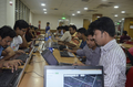
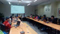
Busy at Work
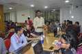
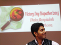
Giving Speech during event
Active


- Event for Mogbazar Missing Maps Mapathon; Bangladesh wiki documentation & OSGeo meeting at Jamuna Conference Hall with cordial support of The World Bank Bangladesh.
Happy OSM_BD Family
The Pioneer
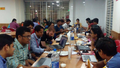
Working
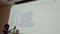
Documentation for Wiki
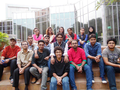
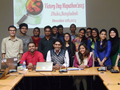
The Team


Mapping Projects
- Rohingya Crisis camp mapping, started September 2017, and is still ongoing. Today's mapping is based on opensource IOM drone imagery. To follow up on this project and provide support, visit dedicated wiki page.
- Save the Children Bangladesh is working for a project to collect data from slum areas of Dhaka initially Bauniabadh(Mirpur-11) and Paris Road(Mirpur-10,11) and present them as an app for mobile for better access of different information in that area. Through this anybody can get information of that area easily; information includes schools, shops, law centres, pharmacies, services etc. The project is named as KOLOROB. Kolorob Facebook


- Y Care UK and YMCA training At Savar YMCA
- Second training on OSM Mapping was held at Savar YMCA Center for 20 ICS UK Volunteers and 20 BD Volunteers. The training session was mentored by Mr. Tasauf A Baki Billah, one of the OSM pioneer in Bangladesh; which was a day long training.


Humanitarian OpenStreetMap Team(HOT) [1] received a grant from Hewlet Packard Foundation [2] to develop an online curriculum on disaster management. It hold two training on disaster mapping, activation curriculum of HOT; one in Dar Es Salaam, Tanzania and another one in Jakarta, Indonesia. They invited several persons from Nepal, Philippines, Bangladesh, Indonesia and USA. Two members from OSM Bangladesh were invited to take part in that great event. It was a great achievement for OSM Bangladesh Team.
For Details follow the link [3]
- Y Care UK and YMCA Bangladesh Project
- Y care UK in partnership with YMCA Bangladesh, conducted a field survey at two disaster prone area in Bangladesh. The selected area was Netrokona and Anowara Chittagong. A coordinator came from UK; from the Y Care International in Bangladesh to bring out the project successfully. This mapping survey was also supported by OSM Bangladesh team.


For project related information kindly follow the link [4]
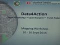
- BDRCS and American Red Cross Data4Action Project
- Bangladesh Red Crescent Society along with American Red Cross; have taken an initiative to put vulnerable places in Dhaka into a map. The project was titled as Data4Action. The project mapping was supported by Open Street Map Bangladesh Community. Main goal of this project is to map different every buildings in the vulnerable area with an android application which has been developed by American Red Cross GIS team. Initial survey areas as selected are Gandaria and Moghbazar. Mapping of every building at Gandaria has already been done with Bangladesh Red Crescent Society volunteers and OSM BD Volunteers. Outcome of the initial project work is really fruitful.

- Data for action 02.jpg
- Data for action 01.jpg
- Data for action 03.jpg


- Stanford University Medicine School and IEDCR Health Project
- Conducted a field survey at the District of Netrokona for a project of medical technology application test at the field level. This survey was carried out jointly by Stanford University-USA-Medicine School and institute of epidemiology disease control and research IEDCR Bangladesh. This project was mentored by Dr. Eric J. Nelson, Dr. Jennifer Farrel and Dr. Waliur Rahman.


- Stanford University Geospatial Center and Eastern University Bangladesh Mapathon
- Whole day Mapathon Event jointly organized by Eastern University Bangladesh and Stanford University Geo-Spatial Center.In this mapathon event; mapping support was provided by Open Street Map Bangladesh Community.


- Asia Foundation Bangladesh and Election Working Group Polling Station Mapping
- In the month of April, Asia foundation Bangladesh along with Bangladesh Election Working Group hosts a Map-Up event to geo-locate different polling stations all over Dhaka; along with photo. Open Street Map Bangladesh Community helps to collect all the data in a single day along with photos. For the working planning, a meeting and training held at a restaurant in Dhaka. The work was done in the next day, by hosting a certificate giving program.

- Missing Maps Project in Dhaka
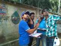
- Missing Mapsː mapping Kamrangirchar and Hazaribaghː The Missing Maps Project and the Humanitarian OSM Team (HOT) have completed the field mapping activities in the areas of Kamrangirchar and Hazaribagh in Dhaka (January 2015). The map is intended to make it easier for individuals, organisations and NGOs working there to provide for those in need. For a summary of activities, decisions and challenges, please see Missing Maps Bangladesh Field Mapping Jan15.Huge thanks to the tireless work and enthusiasm of the OSM Bangladesh community.


- MapBUET: This was the first project done by the students of the Department of Computer Science and Engineering, Bangladesh University of Engineering and technology (BUET). They took a number of waypoints with their Garmins and made map of the campus using JOSM. Finally they donated the map to OSM. Link: BUET. This map was given to the freshers who joined the Department of Computer Science and Engineering of BUET in February, 2011 (CSE 2010 Batch). The people who were involved in making this map are: Sufian Latif, K. M. Rakibul Islam. Md. Monjurul Islam Khan, Md. Rashidujjaman Rifat, Ishrat Ahmed and Syed Ishtiaque Ahmed.
- Mapping Old Dhaka: Old Dhaka is the older part of the Dhaka City. It is very congested, crowded and over-populated place. The streets are very narrow and traffic jams are very common occurrences there. There are some very old and risky buildings in this part of the city which cause severe accidents. Moreover, some severe fire-accidents take place here in every year. Hence, the OSM group decided to map Old Dhaka. In February 26, 2011. 5 groups of mappers covered different parts of Old Dhaka and gathered GPS traces. This project is still going on. The people who were involved in this project include Sufian Latif, K. M. Rakibul Islam, Monjurul Islam Khan, Md. Rashidujjaman Rifat, Anika Anwar, Ishrat Ahmed, Samiha Samrose, Aniqua Zahra Qazi, Rafid Wahid Yaad, Shabnam Basera Rishta, Zawad Hossain, Nazia Nusrat Shoumi, Maliha fawzia farah, Arefin Khan, Muhammad Hussain Mahdi and Syed Ishtiaque Ahmed.
- Mapping Sylhet City: Sylhet division occupies the north east part of Bangladesh, has an area of 12596 sq. km and a population of 7.899 million. There are 4 districts and 14 municipalities under Sylhet. It is a natural hilly, forest area with ox bow lakes and famous shrines. Sylhet city is nestled in the picturesque Surma Valley amidst scenic tea plantations and lush green tropical forests, greater Sylhet is a prime attraction for all tourists visiting Bangladesh. To attract more tourists I (Anup Datta) have decided to map (GIS) Sylhet City's Transport Network, all tourist spots and available facilities.
- Mapping at Chittagong: One of the 5 GPS units received from OSI Foundation was given to Chittagong University of Engineering and Technology (CUET) to start OSM there. A workshop on mapping was conducted there by Md. Rashidujjaman Rifat and Shubrami Moutushy.Two Lecturers of CUET, Tauhidul Alam and Jobaida Akhtar are leading the students there. Sabbir Ahmad Majumder, Md. Kamrujjaman Akon and Imam Mohammad Bokhary are actively involved in mapping the places around Chittagong.
Awards
- Location-Based Services: A project done by two sophomore BUET students, Md. Rashidujjaman Rifat and Shubrami Moutushy, won the 1st prize at Inter-University Software Project Show held at Chittagong University of Engineering and Technology (CUET). They developed an Android application that can help a blind people to find the destination.
Publications
- A paper on 'OpenStreetMap for the Disaster Management in Bangladesh' has been accepted in 2011 IEEE Conference on Open Systems (ICOS2011). Authors of that paper are Syed Ishtiaque Ahmed, Sufian Latif, Md. Monjurul Islam Khan, K.M. Rakibul Islam. It is a great achievement for Open Street Map in Bangladesh.
- Paper on 'Location Based Information System Using OpenStreetMap' has been accepted in International Conference on Advances in Electrical Engineering (ICAEE-2011). Authors of that paper are Md. Rashidujjaman Rifat, Shubrami Moutushy, Hasan Shahid Ferdous and Syed Ishtiaque Ahmed. It is another bigger success of OpenStreetMap in Bangladesh.
- Paper on 'Location Based Information System Using OpenStreetMap' has been accepted in IEEE Student Conference on Research and Development (SCORED-2011). Authors of that paper are Md. Rashidujjaman Rifat, Shubrami Moutushy, Hasan Shahid Ferdous and Syed Ishtiaque Ahmed. The best achievement of application side of OSM in Bangladesh with an android app.
- Paper on 'Location Based Early Disaster Warning and Evacuation System On Mobile Phones Using OpenStreetMap' has been published in Proceedings of IEEE Conference on Open Systems, Malaysia, (ICOS 2012). Authors of this paper are Khandaker Mustakimur Rahman and Tauhidul Alam. It's a part our OSM community work at Chittagong, Bangladesh.
- Paper on 'Location Based Emergency Medical Assistance System Using OpenstreetMap' has been published in Proceedings of International Conference on Informatics, Electronics and Vision (ICIEV 2014). Authors of this paper are Rajib Chandra Das and Tauhidul Alam. It's another success of our OSM community work at Chittagong, Bangladesh.
Mapping Party
February 21, 2011: The first Mapping Party of OSM BD took place at a small kindergarten school at Dhanmondi, Dhaka. This date was particularly memorable as this was the International Mother Tongue Day. Almost 30 people attended this party. There were three presentations. At first, Sohaila Ridwan, the lead of CommunityAction, A volunteer group, made her speech on leadership. Then Syed Ishtiaque Ahmed explained the necessity of OSM in his presentation. Finally K. M. Rakibul Islam, an undergraduate student of CSE, BUET showed how to make maps to the audience.
| Local user group | |
| Open Street Map Bangladesh Community | |
| Meetings | |
| When: | On Planned Dates fixed for meeting |
|---|---|
| Where: | Place declared on the OSM BD Facebook page (map) |
| Mailing list | |
| mailing list – archive | |
| Website | |
| Open StreetMap Bangladesh] | |
| Image | |

| |
Divisions
Imagery and data sources
Yahoo hires imagery
Bing hires imagery
Hires Bing coverage appears in green in this interactive map (zoom in at least at level 14 to trigger new rendering).
- Dhaka area coverage (same as Yahoo, zoom level 17, Jan 2001 - Apr 2005)
- Dhaka smaller area coverage (zoom level 18, Oct 2006 - Apr 2010)
- Chittagong (same as Yahoo, zoom level 17, Nov 2000 - Nov 2004)
- Chittagong (zoom level 18, Oct 2006 - Apr 2010)
- Khulna (zoom level 18, Oct 2006 - Apr 2010)
- Rajshahi area
- Pabna and Bogra area
OrbView-3 hires imagery
144 OrbView-3 satellite images of Bangladesh, made freely available by USGS, with less than 10% cloud cover, terrain corrected (L1Gst), with enhanced contrast, are available for use as background in OSM editors.
Use with Potlatch : For Potlatch 2, in menu "Background / Edit / Add", give a name (for example "Bangladesh - OrbView-3"), and copy the following URL:
http://osm.arkemie.org/cgi-bin/tiles/1.0.0/bangladesh/$z/$x/$y
(you can also uncheck "Dim").
For Potlatch 1, open "Options (choose background map)" dialog window, and copy-paste the following URL in "Custom":
http://osm.arkemie.org/cgi-bin/tiles/1.0.0/bangladesh/!/!/!
(you can also uncheck "Dim background").
Use with JOSM :
To make the image available in the Imagery menu in JOSM, go to Modify / Preferences / WMS - TMS tab / +, give a name (for example "Bangladesh - OrbView-3"), and copy-paste the following URL in "Web address" (bottom):
tms[19]:http://osm.arkemie.org/cgi-bin/tiles/1.0.0/bangladesh/{zoom}/{x}/{y}
Use source=OrbView-3, USGS, 2003-2007.
Quality controls
People involved
- Ahasanul Hoque [5]
- Tasauf A Baki Billah [6]
- Md. Sajjad Hossen Sapan [7]
- Minhaz Mahmud [8]
- S.M.Sawan Shariar [9]
- Maliha Binte Mohiuddin [10]
- Israt Jahan [11]
- Iftakhar Ahmed [12]
- MD. Samsul Arafin [13]
- Kazi Abdur Nur Tusher [14]
- Antara Das [15]
- Farhana Sarwar [16]
- Khan Zarin Tasnim [17]
- Md. Rownak Islam [18]
- Hasan Mahmud [19]
- Syeda Shahida Maknun [20]
- Tasnuva Shabnam Udita [21]
- Nabila Ahmed Orin [22]
- Redita rokib [23]
- Mirza Md. Tasnim Mukarram [24]
- Shahadat Hossain Sujon [25]
- Tahrima H Moon [26]
- Asura Akter Sunna [27]
- Mahfuzur Rahaman [28]
- Muhammad Arifur Rahman [29]
- Saadh Bin Islam [30]
- Arefa Hossain Antora [31]
- Syed Ishtiaque Ahmed [32]
- K. M. Rakibul Islam [33]
- Md. Monjurul Islam Khan [34]
- François de Ryckel flipo
- Fazlay s21rc
- Syed Anwar [35]
- Mohammad Haque [36]
- Larry O'Neill [37]
- Sufian Latif [38]
- Anup Datta [39]
- Sohaila Ridwan [40]
- Md. Rashidujjaman Rifat [41]
- Md Alamgir [42]
- Junaid Ahmed [43]
- Atikur Rahman atik [44]
- Manjurul Islam [45]
- Nasir Khan Saikat [46]