WikiProject Belgium/Activities
| WikiProject Belgium +/- | ||
| Conventions | ||
| Subprojects | ||
This is a list of all activities in Belgium. Activities include mapping parties, social OSM gatherings, conferences of interest to OSM, ...
We have regular informal meetings, organized through Meetup [1] and published on osmcal. Not all activities are listed here. It's safe to check both Meetup.com and this page. You are invited to suggest meetups in your town!
We also have an irregular newsletter [2] where we announce events.
General Information
Some guidelines to start a (Micro) mapping party can be found on the wiki:
If voting is necessary (for date, location, ...), you can use the voting system on: Framadate (similar to Doodle but free and privacy conscious).
Upcoming activities
Past activities
2019-05-06 - Arlon OSM Meetup
Pub meeting. Syndicat d'Initiative - Salle Piano. Rue de Clémarais 28A, 6790 Aubange [[3]], Belgium. At 19.30 h.
2017-10-24 - Arlon OSM Meetup
Pub meeting. Taverne Les Arcades, place Léopold 5, Arlon, Belgium. At 19.30 h.
State of the Map 2016, Brussels
From 23-25 september 2016. More info on the website and the OSMF blog.
2016-06-06 Missing Maps Mapathon @ Doctors without borders - Handicap International, Brussels
Missing maps mapathon for and at Doctors without borders and Handical International in Brussels. For more info see osm.be
2016-04-16 National Missing Maps Mapathon
The biggest mapathon ever at seven universities in Belgium
More info: http://www.internationalmapyear.be/mapathon.php & http://osm.be/nl/content/national-mapathon-swaziland
Press: http://m.deredactie.be/#!/snippet/57122016c9976f6b4ffd7426
2016-01-23 Missing Maps Mapathon, Ghent
Jan 23th, 2016. Mapping away for the Missing Maps. More info on the OSM.be blog
2015-12-09 Missing Maps Mapathon, Antwerp
Dec 9th. 2015. Mapping away for the Missing Maps. More info on the OSM.be blog
2015-04-25 Mapping party in Brussels - 9h till 13h
We are proposing a mapping party in Brussels on Saturday 25 April 2015, 9h till 13h.
The location for the meetup as well as for the work together is ESI École supérieure d'informatique . The address is : Rue Royale 67, 1000 Bruxelles. It is very close to Central station and the Federal Parliament. It has easy access by train (Central station), tram (92,93), bus (29,63,65,66), metro (Parc, Madou, Botanique) as well as by car on a Saturday morning.
The idea is to have a mapping party aimed at beginner mappers with the help of advanced ones, and to focus on improving Opencyclemap and Wheelmap. Everyone is welcome.
Are any of you interested in helping with the organization, the plan, the introductory talk, the advertisement everywhere (in newspapers, radio, TV ...) ... ?
Please fill out the survey on https://framadate.org/vspmbw9xba5pfasn
The preparation could be supported by several Google Hangout meetings.
Proposal
- improve opencyclemap, a map for cyclists ;
- improve wheelmap, a map aimed at everyone with special needs ;
- take pictures and movies of routes, and everything on the way ;
- take pictures of every MIVB/STIB/TEC/SNCB/De Lijn metro/tram/bus/train stops ;
- report anything complementary interesting (street works, post boxes, shops ...)
In the afternoon we could experiment outside with Mapillary. Is there a place we could continue inside ?
Are there computer screens with HDMI input at our disposal ?
Who does what
- JOSM for beginners by Polyglot or Marc Gemis (he's really good at explaining :-);
- Mapillary by Peter Neubauer ;
- Demo of umap by Polyglot (http://umap.openstreetmap.fr/nl/map/openbaar-vervoer-rond-leuven_30737 http://umap.openstreetmap.fr/nl/map/rer-paris_30738 (up and running in 10 minutes))
- I could tell about my picturing of the Brussels pentagon.(PhilippeC)
- [please add your idea here]
Nous vous proposons une cartopartie à Bruxelles le samedi 25 Avril 2015, de 9h à 13h.
Lieu de cette rencontre et de collaboration: ESI École supérieure d'informatique. L'adresse est: Rue Royale 67, 1000 Bruxelles , auditoire 004. L'école est située près de la gare centrale et du Parlement fédéral. L'accès y est facile par le train, le tram (92-93), bus (29,63,64,65,66) , métro (stations Madou, Botanique ou Parc) ainsi qu'en voiture ce samedi matin.
Cette rencontre s'adresse à des cartographes débutants qui recevront l'appui de cartographes confirmés, et a pour objet l'amélioration de la OpenCycleMap et Wheelmap. Tout le monde est le bienvenu !
Si vous êtes intéressé à aider à l'organisation, au planning, à la présentation d'introduction, à la communication(dans les journaux, radios, télévisions, ...) ...?
Veuillez remplir le sondage sur : https://framadate.org/vspmbw9xba5pfasn
La préparation pourrait être soutenue par plusieurs réunions Google Hangout.
Proposition
- Améliorer OpenCycleMap, une carte pour les cyclistes;
- Améliorer Wheelmap, une carte destinée à tout le monde avec des besoins spéciaux;
- Prendre des photos et films des voiries, et tout autre information signalétique ou intéressante sur la voie;
- Récolte de photos de chaque station STIB / MIVB/ TEC / SNCB / De Lijn , partout où les métro / tram / bus / train s'arrêtent;
- Signaler toute information complémentaire intéressante (des travaux de voirie, boîtes aux lettres, magasins ...)
Pour les PMR
- brochure PMR par Cap 48 : à quoi faut-il faire attention ?
- Mobilité et PMR à la Stib
- Cadastre des Points d'Arrêt Non-Gardés en Wallonie
- Access-i, le portail d'information sur l'accessibilité
Qui fait quoi
- JOSM pour les débutants par Polyglot;
- Mapillary par Polyglot;
- [Se il vous plaît ajouter votre idée ici]
2013-11-08 Google Hangout
Topics/Onderwerpen
Using my work on protected monuments, I'll try to present: / Gebruik makende van mijn werk rond beschermde monumenten, zal ik proberen de volgende onderwerpen te behandelen
- Presenting Geschichtskarte (en) / Voorstelling Geschichtskarte (nl)
- Convert Wikipedia page into osm-file / Omzetten Wikipedia pagina naar osm-file
- Working with multiple layers in JOSM / Werken met meerdere lagen in JOSM
- Merging existing data with imported data / Samenvoegen bestaande gegevens met geïmporteerde data
- Faster ways to add multiple tags / Snellere methodes om meerdere tags toe te voegen
Those techniques will also be useful during an import of Agiv/Crab data / Deze technieken zijn ook bruikbaar gedurende de import van Agiv/Crab gegevens
language: normally Dutch, maybe English / Voertaal: normaal gezien Nederlands, misschien Engels
We also discussed some topics related to the AGIV CRAB import
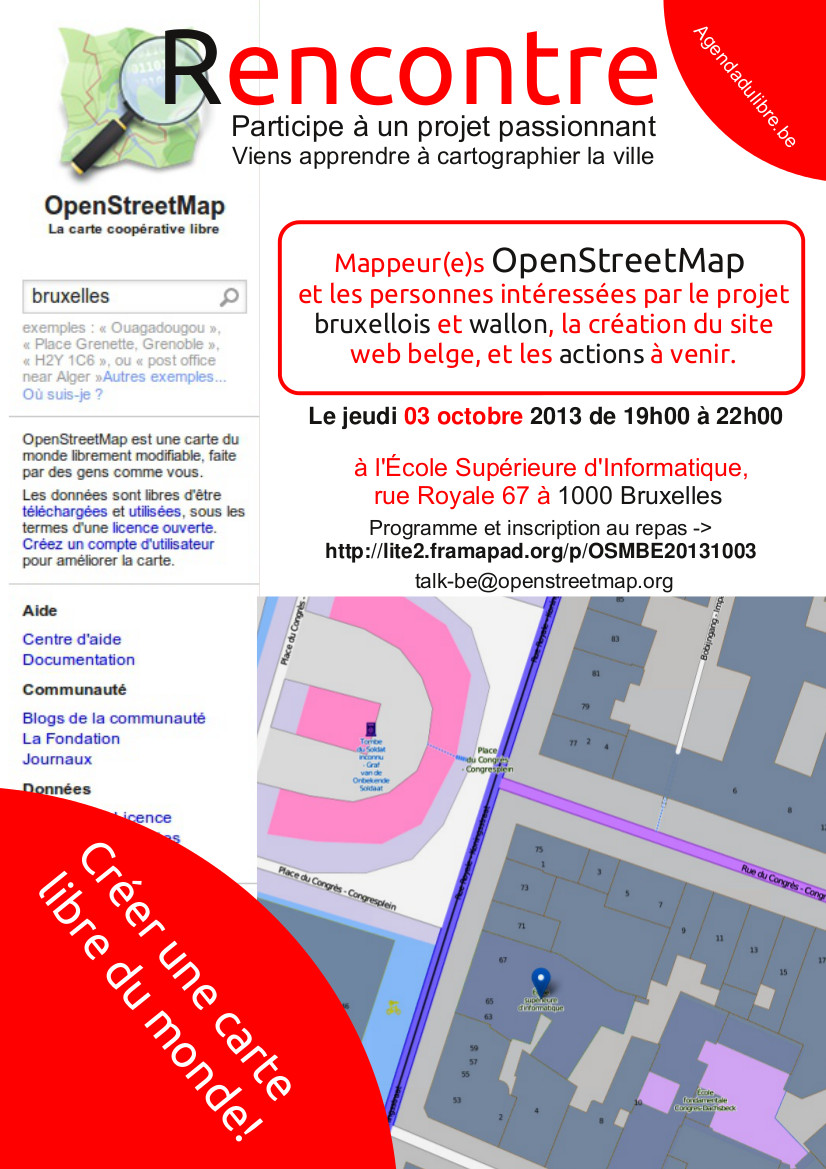
2013-10-03 - A meeting at École supérieure d'informatique
A meeting at École supérieure d'informatique ( http://osm.org/go/0EoTiW96D--?m= , rue Royale 67 à 1000 Bruxelles. Organized by Nicolas Pettiaux.
The original agenda: http://lite2.framapad.org/p/OSMBE20131003 and poster Media:Poster_OSM_Meeting_ESI_20131013.jpg
- Presentation of the participants: some experienced mappers, people coming from an open-data and open software background, 1 open-sea-mapper, a journalist
- State of the Map Belgium, see https://docs.google.com/presentation/d/1F69PAR44JF3pBE1mBuv-8VaNmkyIOxxQhcAYEM_PuWo/edit?usp=sharing
- Some web site one can use to decide on the completeness of the map
- Quality control website
- Topic maps to show there is more than navigation data for cars
- Overpass to query the data
- OSM Belgium needs you, whether you are a mapper, technical writer, translator, ... there is more than mapping alone
- Mapping overview (mostly demo's), see https://docs.google.com/presentation/d/1qsrZfYJ-8SUz7Ww3-sZ1Q3zsASdQP7wCsQ0_Bg6YynY/edit?usp=sharing
- From edits with ID based on local knowledge
- Via satellite image tracing
- HOT (presented by Ben, who is very knowledgable in this field)
- Surveys (GPX traces, waypoints, images)
- to simple imports (conversion of PDF -> spreadsheet -> comma separated file -> via JOSM + OpenData plugin + manual check -> OSM
- Briefly on Data of the Lijn
- Import of Wikipedia data of protected monuments via python script -> osm-file for use in JOSM. Again stressing that manual check is needed
- Presentation of project with firefighters in Namur.
- Data of streets needs to be enhanced
- they will add specific data related to their work (large trucks)
- OSM will receive input on new roads, etc. once it is in place
- project is currently being reviewed by firefighters hierarchy
- Overview of OSM Belgium website
- Focus on what we want to achieve (see France)
- Bring people closer together (in their own language), presenting the on-going projects, news, etc
- domain name will be transferred soon.
- need people that can deliver content (and translate)
- The creation of a vzw
- Needed for funding (example from France)
- domain name belongs to organization, better than to an individual
- can be as a chapter of the global OSM organization
- which steps are required, follow-up via mailing list
2013-06-19: OpenStreetMap Meetup!
The third OpenStreetMap meetup in Ghent! Everybody welcome!
2013-11-29 Google Hangout
Hangout URL : https://plus.google.com/hangouts/_/76cpi0etss02ht6h4f4cf1qg9c?hl=en
De hangout kon niet doorgaan op 2013-11-22, maar werd een weekje uitgesteld
Onderwerpen
- Survey + invoeren van wandelknooppunten inclusief "tentakels"
- Script om knooppuntnetwerken (fietsen en wandelen) te controleren
Tijdstip: 20u-22u
De link wordt rond 19u30 op de Belgische en Nederlandse mailing lijst gezet
--Escada (talk) 20:49, 14 November 2013 (UTC)
2013-05-24/25: Formation à la carto partie
Type: Training
Location: Frasnes-Lez-Anvaing (Hainaut)
Date: vendredi et samedi 24 et 25 mai de 9h à 17h
Promoter: Cooptic Belgique
Info
2013-02-02/03: FOSDEM, Brussels
Type: Conference
Location: Campus Solbosch, Brussels
Date: Saturday and Sunday, 2nd and 3rd of February 2013 10-18h
FOSDEM
2013-02-09: Informal talk, Lier
Type: Meeting
Location: Café Refuge, Zimmerplein 12, Lier
Date: Saturday, 9th of February 2013 10-17h
Talk:WikiProject_Belgium/Activities#2013-02-09:_Meeting_in_Lier
2013-01-17: Jeudis du libre, Mons
Type: Presentation
Location: UMONS (faculté Polytechnique)
Date: Thursday, 17th of January 2013 at 19:00
jeudis du libre
2013-01-06: New Year's drink STUK, Leuven
Type: informal talk
Location: Leuven STUK kunstencentrum, Naamsestraat 96, Leuven, tel 016 320 300
Date: Friday, 6th of January 2012 at 19:00
Parking (betalend: avondtarief van 3 euro tussen 19u en 3u): Heilig Hartkliniek
2012-09-12 Meeting in Namur about PICC
2011-10-09: Introduction to OSM for Africa4U
Type: Introduction to OSM for Africa4U.
Location: Sint-Veerleplein 3 - 301, 9000 Belgium [4]
Date: 9 okt
Organisation: Ben
Note: This event is for the Africa4U people, but if you are willing to help or meet some other mappers you are welcome to join. The focus will be on OSM at an introductory level however and teaching the people of Africa4U how to use OSM in their mapping activities.
2011-05-13: 5th Informal Talk, ASBL Barricade, Liege
Type: Informal Talk
Location: Barricade, Rue Pierreuse 19-21, Liege
Date: Friday, 13th of May 2011 at 7PM
Station: [5], Parking: Place Saint-Lambert
Organisation: Jo, Julien Fastré and Benoît Coumont
Note: Some member of associations in Liege were also invited to discover the community. The responsible of the cartographic department of the City of Liege was also invited.
---
Present:
--Julienfastre 10:27, 7 April 2011 (BST)
--Polyglot 12:27, 7 April 2011 (BST)
--Benoît Coumont
Your name here...
---
Agenda
- kennismaking
- talk with other association
- tips and tricks for JOSM (by Jo) (we have a projector)
- What are the priorities ?
- What ressources the city of Liege could give and how ?
- Which method adopt to add RAVeL, Rando Velo and cycle ways ? How to do ? There are regional bike network in Wallonia ?
- Rando Velo needs help to edit a new bike guidebook with osm maps. Could we help ?
- (insert here what you want...)
2011-04-06: 4th Informal talk STUK, Leuven
Type: informal talk
Location: Leuven STUK kunstencentrum, Naamsestraat 96, Leuven, tel 016 320 300
Date: Wednesday, 6th of April 2011 at 19:30
Parking (betalend: avondtarief van 3 euro tussen 19u en 3u): Heilig Hartkliniek
Agenda
- kennismaking
- flyer OSM
- cycleway / footway
- landuse
- oprichten user_group ?
- vul hier uw suggesties in
Besproken:
- Gebouwen op een efficiënte wijze maken in JOSM gebruik makend van AddrInterpolation, BuildingsTools en Terracer. Er zijn nog een paar zwakke punten in dit workflow ivm. hoe Terracer punten (en dus ook hun history) verwijdert.
- Het gebruik van associatedStreet in een industriezone of campus. Deze gebieden kunnen nog niet echt goed geadresseerd worden, en worden ook niet door Nominatim gedetecteerd. Mogelijk moeten we een voorstel doen om associatedStreet uit te breiden waarbij de 'street' ook een gebied mag zijn.
- Scripting met Python in JOSM. We zijn er aan uit geraakt hoe een script te schrijven dat een tag kan toevoegen aan een node. Dit testscriptje zal ergens online komen, en nu dat de juiste workflow gekend is kan de syntax uit voorbeelden in andere talen (Groovy bvb.) gehaald worden (API blijkt tot zover identiek te zijn) en scripts geschreven worden.
2011-03-16: 3th Informal talk STUK, Leuven
Type: informal talk
Location: Leuven STUK kunstencentrum, Naamsestraat 96, Leuven, tel 016 320 300
Date: Wednesday, 16th of March 2011 at 19:15
Parking (betalend: avondtarief van 3 euro tussen 19u en 3u): Heilig Hartkliniek
Present:
Jo
Ivo De Broeck
Gerard
Karel Adams
Jan-willem
Agenda
- kennismaking
- huisnummers - potlach 2/JOSM
- landuse en farm/farmyard/farmland/field
Conclusies:
- farmland is een duidelijkere tag voor farm, omdat sommigen voordien de farmyard aanduidden als farm
- farmyard = "het erf" van een boerderij = stukje land waar de bedrijfsgebouwen staan
- farmland = landbouwgrond
- maandelijkse samenkomsten elke 1ste woensdag van de maand : volgende vergadering = 6 april om 19:30
2010-04-18: Mapping party Deinze, east-flanders
- Type: Mapping party
- Date: Sunday April 18th, 2010
- Start time: 10h00 local
- Location: Start at Deinze Railway station, finals at De Ceder (www.deceder.be)
- Attended: kenny, ivo, ben, wouter, dirk, ivan, Almost forgotten Luc Speedy, karel
Party began with an extensive newspaper interview. And we did get newspaper coverage! De Gentenaar / Het Nieuwsblad
Unfortunately one person's GPS traces were lost through the miracles of technology. Fair progress was made but much remains to be done.
Cake diagram

Results
- Industriezone Europalaan
- from Europalaan till village Machelen
- Woonwijken Watertorenstraat & Molenpark
Still to be done
- links from Petegem to the N43 road (Tonnestraat, Hubertstraat, ...)
- Village Machelen (some footpaths there), and everything South and West from there
(( left here the previous text from the "upcoming" section ))
Some people in Eastflanders are planning a mapping party in April. The location would be Deinze. As far as OSM is concerned this is mostly terra incognita https://www.openstreetmap.org/?lat=50.989019&lon=3.5&zoom=12 so it should be spectacular to go mapping there.
It's also easily accessed by train and by highway (E17). The date is fixed at Sunday April 18. A first start of the splitup of the territory can be found here (made use of the competition :) http://maps.google.be/maps/ms?hl=nl&ie=UTF8&msa=0&msid=115156197198343391457.0004820fe7d0e9e1e145b&z=12.
We will meet at the station at 10am, gather tracks until 1pm, grab a bite and go to De Ceder (www.deceder.be) where we will have a meeting-room at our disposal. Bike hiring could be done in http://www.hetverzet.be/ for about 11€/day which is about the same thing as bringing it along on the train (9€ for a day pass; 5€ for one ride only). Please notify me if you are interested. Pietje leugenaar 07:05, 30 March 2010 (UTC)
2010-03-28: Mapping party Turnhout

- Type: Mapping party
- Date: Sunday March 28
- Start time: 10h00
- Location: Brasserie't Stadspark, Parklaan 56, Turnhout. The site of the brasserie has a map here. Should not be too hard to find
- Attended: eimai, speedy, ivom, mdeen, karel, kurt, filip wolters
A mapping party was held in the city of Turnhout and it's surroundings. Some zones were mapped, and after rain shower the party turned in a lively OSM-cafe meeting.
Cake diagram

The cake map is based on a tiny dataset, which contains a set of closed ways (waterway=river, name=3 for zone 3) and for each closed way a separate place=suburb, name=Zone 3" is used. The actual map is built by rolling the data through mapnik on top of a simplified base layer (basically streets and landuse).
The Garmin gmapsupp.img file contains two osm-data derived maps (base map + a maplint version) and the zones as separate maps created with MkgMap. The idea here is to be able to visit certain zones and stay within them. The idea was tried out during the mapping party and was useful for some Garmin users.
Results
The resulting traces from the party you find on the right.

Zone beschrijvingen die werden gemapped voor bovenstaand cake diagram
| Zone | Todo |
| 10 | nieuwe wijken schorvoort + gommers (done) |
| 11 | parkzone en doodlopende straatjes (done) |
| 12 | waarschijnlijk kmo-zone in aanbouw (done) |
LeftOvers: Zone beschrijvingen die niet werden gemapped
| Zone | Todo |
| 1-5 | fietspaden,eenrichting straten, winkels, nutsvoorzieningen |
| 6 | ontbrekende buurten inclusief straten en alles |
| 7 | vermoedelijk correct. meer iets voor kilometervreters en natuurliefhebbers of allebei :) |
| 9 | kmo zone |
| 13 | Grotendeels ok, alleen tussen 'speelkaartenstraat' en Steenweg op Gierle /
ring ontbreken nog enkele recente woonstraten. |
| 22 | Tussen Tielendijk / Kapelweg / Duivendongenstraat ontbreekt nog een hele
woonwijk. Tussen Kapelweg en de N19 is ook nog een voetwegje . |
2009-06-21: 1e OSM-CAFE Antwerpen
- Location: Antwerpen, Van Boendalestraat 8, 2000 Antwerpen
- 500 m van centraal station
- 200 m van Franklin Rooseveltplaats
- zie http://www.bb2000.be/stratenzoeker
- Wanneer: Zondag 21 juni, van 13.00 tot ...
- Voor wie: Alle mappers, in het bijzonder die aktief in Antwerpen
- Agenda:
- opsplitsing van het gebied in zones
- bespreking van praktische problemen
- maken van verdere afspraken
- beschikbaar:
- netwerk (wired & wireless)
- koffie, thee, frisdrank & bier
- broodjes & koffiekoeken
Wie wenst te komen, graag even vooraf aanmelden met een mailtje aan luc.antw@gmail.com Vermeld eventueel ook ineens welke onderwerpen je graag aan bod ziet komen.
List of participants:
Toi
2008-10-19: Mapping party Hoboken


- Type: Micro mapping party
- Date: Sunday 19th of October 2008
- Start time: 10h00
- Participants:
Vanwege een dikke witte wolk boven Hoboken, Antwerpen (Yahoo Aerial Imagery) werd Hoboken Polderstad en een groot deel van Hoboken en stukje Wilrijk verder in kaart gebracht.
2008-03-22: Mapping party Lier

- Type: Mapping party
- Date: Saturday 22nd of March 2008
- Start time: 10h00
- Place to be: Taverne Zuster Agnes: Schapenkoppenstraat 16 - B-2500 LIER
- Location: Lier
- List of participants:
Gyrbo
Filip
Hermes
Ivom
Motomarc
Toi
Polyglot
2008-02-23/24: FOSDEM
Location: Brussels
Type: Convention
Date: 23-24 February 2008
List of participants:
Polyglot
Gyrbo
Raskas
Toi
PhilippeP(Sunday pm)
Fcauwe
Eimai
2008-02-09: Mapping party Mechelen
Location: Mechelen
Type: Mapping party
Date: 9 February 2008
Start time: 10h45
Place to be: Café/restaurant Keizer Karel, Veemarkt 20
List of participants:
Polyglot
Gyrbo
Toi
Ivom
André Maes
Hermes
Divided Mechelen and went to conquer it for a good hour. Then we got back, ate a good meal, attempted to fix the wireless and exchanged some tips and tricks about mapping and tagging. --Polyglot 18:37, 9 February 2008 (UTC)
2007-09-16: Mapping party Brussel
Location: Brussels
Type: Mapping party
Date: Sunday 16 September 2007
2007-07-16: Mapping party Brussel
Location: Brussels
Type: Mapping party
Date: 16 July 2007
????-01-31: 2nd Informal talk STUK, Leuven
Type: informal talk
Location: Leuven
Date: Thursday, 31th of January
Present: Polyglot Orwall Gyrbo Toi Tokesnugerd
Some discussion about what tag makes sense for which type of 'highway' here in Belgium. The NMBS railway data will be for a later date.
2008-01-24: 1st Informal talk STUK, Leuven
Type: informal talk
Location: Leuven
Date: Thursday, 24th of January
Present:
Polyglot
Gyrbo
Fcauwe
Toi
Mark Van den Borre
Nice evening. Good conversation, we even talked about OSM every once in a while :-). Data loggers, free software and different kinds of software for processing the traces and the pictures were also a topic, of course. It was good to get to know a few people in person.