WikiProject Malawi

- Want to contributeː see the tasks list
- Want to see the last edits of the countryː see the last 90 days map or the last 7 days map and zoom or for claser areas, zoom wherever you want with this tool and create your RSS link if you want to be alerted
- Want GIS dataː click here for the whole country or here or create your own export. For more GIS Data, click here
| V・T・E |
| latitude: -13.280, longitude: 34.294 |
| Browse map of Malawi 13°16′48.00″ S, 34°17′38.40″ E |
| Edit map |
|
External links:
|
| Use this template for your locality |
Malawi is a country in Africa at latitude 13°16′48.00″ South, longitude 34°17′38.40″ East.

Malawi Mapping Project
Situation
Malawi has a dense and, compared to the neighboring countries, well maintained road network. Within the last years, the Malawian Government and the National Roads Authority have successfully made considerable effort to further improve Malawis road infrastructure. Many main roads and even some frequently used minor roads have been tarred, bridges have been renewed and upgraded and a lot of rehabilitation work is going on. Tar roads are generally in good shape and potholes are seldom found.
Nonetheless, for the ingenuous visitor traveling Malawi and used to European or South African Standards the Malawian road network offers some serious pitfalls:
- Besides some turnoffs from major roads, one hardly finds any road signs or signposts.
- The width, condition and look of a road or track does often not reflect the class of the road. The appearance of major roads can vary from high quality tar roads to simple, corrugated tracks with dust holes. Sometimes taking a minor instead of the bad main road can be the better option.
- The routing of classified roads is often arbitrary and illogical with sudden abrupt turnoffs, deviations and changing road conditions.
- The road and track network can be very dense in some areas and with above mentioned inconveniences makes it difficult to discern, which track or direction is the right one to follow.
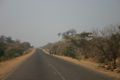
M5 between Salima and Golomoti
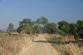
M9 near Mwasizi
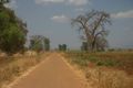
Unclassified road near Salima


Unfortunately there are virtually no suitable printed maps for Malawi. Those maps available are often long outdated, inaccurate or simply wrong. While the major roads are rendered in acceptable quality, secondary or tertiary roads are often almost arbitrarily sketched in , unclassified roads are generally missing.
Available GPS-Maps like Tracks4Africa are accurate but for Malawi they only cover the more frequently used roads. A GPS and your OpenStreetMap for Garmin may therefore be helpful.
Off the major roads a 4x4 or a vehicle with high ground clearance can be helpful. Although the minor roads are often in good shape, there are always missing bridges, gullies or steep or sandy sections.
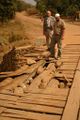
Inspection of a damaged bridge.

Road conditions vary considerably between dry and rainy season. During the rainy season roads or bridges can be washed away, blocked by landslides or just impassable due to mud an deep water holes.
Project objectives
The OSM Malawi Mapping Project started late 2008 with the contributions of three OSM mappers aiming at not only providing an accurate and detailed map of Malawi road network, but also providing up-to-date information about critical spots, like bridges or fords, and the current condition of the respective road; for tourism purposes, interesting adhoc data, such as camp sites, tracks within nature reserves and hiking trails.
From 2014 Humanitarian_OSM_Team aims at creating an OSM community in Malawi that encompasses both governmental institutions, Academics, local authorities, NGOs and civil society, and create links with the online worldwide community.
Contributing
There are several ongoing Tasking Manager jobs for Malawi, that you can access here and here
Lower Shire Community Mapping
Between August and September 2014, Humanitarian_OSM_Team conducts a project funded by GFDDR to train Malawi stakeholders to OSM and organize a Community Mapping in Lower Shire (Chikwawa and Nsanje districts) for flood preparedness. More information can be found here.
You can contribute to map the flood prone areas that will be mapped in the field between mid August and mid September 2014. There are several Tasking Manager jobs that can be found here.
Main cities
The aim is to first get a consolidated maps of roads, streets, residential areas and main buildings as landmarks for every main city. Detailed mapping of every building will follow only once this first essential step is reached. Please find here such job for Blantyre; others will be available soon.
Road network
Tasking Manager job soon available to map the road network
Road Classification Scheme
Please refer to the Highway Tag Africa wiki page
Road classification and road numbering according to information published by Malawi National Roads Authority, 2005-2009
Source: Malawi National Roads Authority (New Website)
Game and Nature Reserves, National Parks
- Lengwe NP (complete)
- Majete GR (partially)
- Tuma FR (partially)
- Nkhotakota GR (complete)
- Kasungu NP (partially)
- Nyika NP (complete)
- Vwaza Marsh NP (partially)
- Liwonde (partially)
- Mvabvi WR (partially)
- Cape Maclear NP (complete)
- Mount Mulanje NR (complete)
- Ntchisi FR (complete)
- Zomba FR (complete)
- Dedza FR (partially)
- Dzalaniama FR (partially)
- Viphy FR (partially)
Hiking
- Chambe Plateau (Mulanje)
- Ntchisi Walking Trails (Ntchisi FR)
- Luwawa Waterfall Trail (Vyphia FR)
Malawi GIS data
- Access the HOT Exports service and create exports jobs to get GIS data on various formats. Here is a link for all Malawi with HDDM tags. Please click on the "Start a new run" button to get up-to-date GIS data within a few minutes.
- To get free OSM data on Garmin GPS devices, please go here. Please find here how to install this map on the GPS Garmin's micro SDcard or on the internal memory of recent devices.
- To get other GIS opendata for Malawi, please visit the [Spatial Data Portal - MASDAP]
Communicating
- Join talk-mw, the mailing list for OSM in Malawi. Its archives are there.
- Join the Facebook group "Malawi OpenStreetMap Community".
Common Tags
These are tags currently being used to map different features in Malawi.
Buildings
This is used to identify individual buildings or groups of connected buildings. The tagging are based on OSM Buildings which can be consulted for further details.
[Section currently being edited]
| Name | Tag | Description | Hyperlink |
|---|---|---|---|
| Building | building | building=yes | |
| Building Level | building:levels | Number of above-ground levels of a building | [1] |
| Building Type | amenity | Assortment of community facilities | |
| Number of Stories | building:levels | Number of stories in a building | |
| Building Material | building:material | Material used for building the walls | |
| Foundation Height | building:foundation_height | Height of the foundation of the building | |
| Roof Material | roof:material | Material for roofing the house | |
| Age of Building | building:age | How many years has the building been up | |
| Number of Stories | building:levels | Number of stories in a building | |
| Street Address | addr:street | Street Address of the building |
Highways
This is used to describe roads and footpaths. Introductory usage are available on the page titled Highways. The Restrictions describes an introduction on access limitations by vehicles type, time, day, load and purpose.
[Section currently being edited]
| Name | Tag | Description | Hyperlink |
|---|---|---|---|
| Highway | highway | highway-yes | |
| Name | highway:name | Name of the highway | |
| Surface | highway:surface | Type of material for the surface | |
| Smoothness | highway:smoothness | How smooth the surface is | |
| Width | highway:width | Width of the road | |
| One way | highway:oneway | Access restrictions |