Zh-hant:Featured images/Jan-Mar 2017
Jump to navigation
Jump to search


這是特色圖片,展現開放街圖畫地圖範例,以及最能代表開放街圖的專案。
如果你知道其他有類似品質的圖片,你可以在特色圖片提名處(en)提名。
| ← 從2016年1月到3月 | ← 從2016年10月到12月 | 從2017年4月到6月 → | 從2018年1月到3月 → |
特色圖片庫、從2017年1月到3月
2017年、第1週
2017年、第2週
2017年、第3週
2017年、第4週
2017年、第5週

2017年、第6週

2017年、第7週
2017年、第8週

2017年、第9週

2017年、第10週

2017年、第11週
2017年、第12週
2017年、第13週
細節和字幕
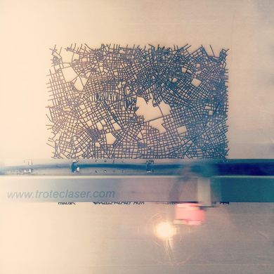
第1週(從2017年1月2日星期一到2017年1月8日星期日) [Edit]

- English : The Mable is a map table, an experimental product featuring OpenStreetMap streets laser-etched into a table top design.
- 中文(繁體) : Mable 是地圖桌,桌面的圖樣依據開放街圖街道資料雷射切割製作而成。
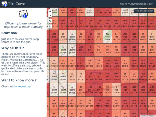
第2週(從2017年1月9日星期一到2017年1月15日星期日) [Edit]

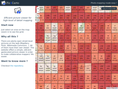
- English : Pic4Carto helps to find useful street-level photos as a source for OpenStreetMap mapping. It shows a grid with the number of open licensed photos to be found in an area.
- 中文(繁體) : Pic4Carto 協助尋找街道等級的圖片來繪製開放街圖,運用顯示數字的格框呈現一個地方能運用的開放授權圖片。
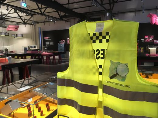
第3週(從2017年1月16日星期一到2017年1月22日星期日) [Edit]

- English : An OpenStreetMap jacket on show at a “Who makes the map” exhibition at the German Museum of Technology.
- 中文(繁體) : 在德國科技博物館的「誰製作地圖」展覽上,展示開放街圖的背心
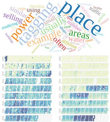
第4週(從2017年1月23日星期一到2017年1月29日星期日) [Edit]

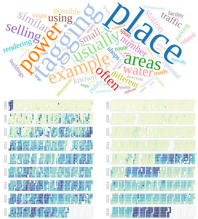
- English : OSMvis is a collection of visualizations related to OpenStreetMap. Top: Most frequent words in the OSM Wiki. Left: Daily amount of new nodes. Right: Number of new users per day. See more visualizations at http://projects.mocnik-science.net/osm-vis/.
- 中文(繁體) : OSMvis 是開放街圖相關的視覺化選輯。上面:OSM wiki 上面出現頻率最多的字。左邊:每日的新節點數。右邊:每天的新使用者數量。可以到 http://projects.mocnik-science.net/osm-vis/ 看更多視覺化例子。
第5週(從2017年1月30日星期一到2017年2月5日星期日) [Edit]

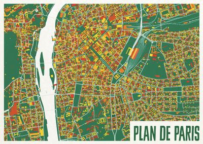
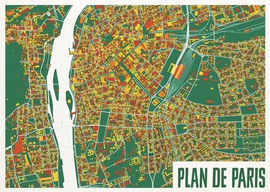
- English : A colourful map from ateljekartan.com. A variety of interesting colour choices are available there to use for ordering poster prints.
(but can you spot the mistake in this image?) - 中文(繁體) : ateljekartan.com出品,色彩鮮豔的巴黎地圖。當要從他們網站訂購輸出海報,有相當多有趣的顏色能挑選。
第6週(從2017年2月6日星期一到2017年2月12日星期日) [Edit]

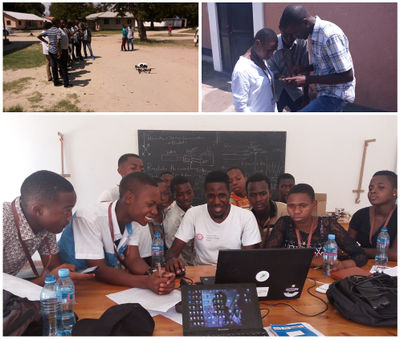
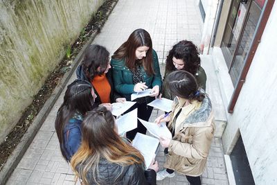
- English : High school students in Bagamoyo, Tanzania, being taught how to gather data and input add to OpenStreetMap, by the Ramani Huria team. Read more on the ramanihuria.org blog.
- 中文(繁體) : Ramani Huria 小組教坦尚尼亞巴加莫約的高中生怎麼收集資料,以及怎麼將收集的資料加到開放街圖上。到 ramanihuria.org 部落格瞭解更多。
第7週(從2017年2月13日星期一到2017年2月19日星期日) [Edit]

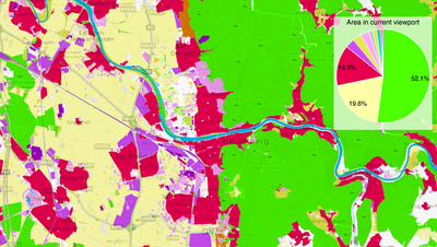
- English : OSMLanduse.org highlights OpenStreetMap's rich landuse/landcover data. The strikingly colourful map shows how our wide range of landcover tags can be broadly classified and analysed.
- 中文(繁體) : OSMLanduse.org突顯顯示開放街圖裡豐富的土地利用/植被資料。這張令人印象深的地圖顯示數量眾多的植被標籤可以廣範被分類和分析。
第8週(從2017年2月20日星期一到2017年2月26日星期日) [Edit]

- English : OSM Mapathon at OpenLabs Albania, a hackerspace in the city of Tirana that are organizing a lot of activities related to OpenStreetMap, Wikipedia and FLOSS. In that mapathon they used FieldPapers.
- 中文(繁體) : 位在地拉那市的 hackerspace OpenLabs Albania 舉行的 OSM 繪圖馬拉松,也舉辦不少跟開放街圖、維基百科和自由和開源軟體相關的活動。在繪圖馬拉松上他們使用 FieldPapers。
第9週(從2017年2月27日星期一到2017年3月5日星期日) [Edit]

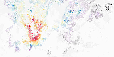
- English : Lauri Vanhala took OpenStreetMap buildings in Helsinki, analysed the location of jobs and travel times from every building, and produced this map to help decide the best place to live. Browse the full map and read more on this blog.
- 中文(繁體) : Lauri Vanhala 用開放街圖赫爾辛基的建築資料,分析各地區職缺數量和每棟建築的通勤時間,製作出這張地圖,協助大家找尋最適合居住的地方。瀏覽整份地圖和到部落格閱讀詳情。
第10週(從2017年3月6日星期一到2017年3月12日星期日) [Edit]

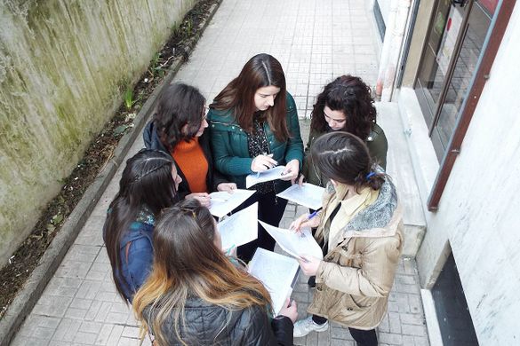
- English : Discussing river area mapping, and Notes at the OpenStreetMap Taipei meet-up. Regular events are listed on the OpenStreetMap Taiwan facebook group.
- 中文(繁體) : 在 OpenStreetMap 臺北聚會上討論如何畫河流和Notes。更多日常聚會訊息可到OpenStreetMap台灣臉書社團查閱。
第11週(從2017年3月13日星期一到2017年3月19日星期日) [Edit]

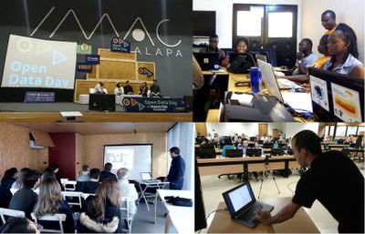
- English : March 4th was OpenDataDay and people all over the world organized small events to talk about and produce Open Data. In a lot of places we had OpenStreetMap activities, like mapping parties, mapathons and talks. Here you can see events in Xalapa (Mexico), Cotonou (Benin), Porto (Portugal) and Brasília (Brazil).
- 中文(繁體) : 3月4日是開放資料日,全球各地的人組織小型的活動,來討論和產製開放資料。而在許多地方也舉行開放街圖活動,像是圖客趴、繪圖馬拉松和演講。你可以看到在哈拉帕(墨西哥)、柯多努(貝南)、波多(葡萄牙)和巴西利亞(巴西)的活動。
第12週(從2017年3月20日星期一到2017年3月26日星期日) [Edit]

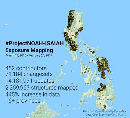
- English : The Nationwide Operational Assessment of Hazards (NOAH) coordinated a series of mapping sessions in the last 12 months that improved the map of Philippines. This data will be used in improving disaster management before, during, and after emergencies. Read more on the NOAH blog.
- 中文(繁體) : 全國災害運作評估 (Nationwide Operational Assessment of Hazards. NOAH)過去 12 個月統合一系列的繪圖行動,大為增進菲律賓的地圖圖資。這些資料會用到改進災害之前、之中和之後的災害管理上面。在 NOAH 計畫部落閱讀更多訊息。
第13週(從2017年3月27日星期一到2017年4月2日星期日) [Edit]

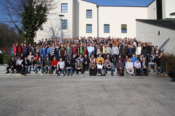
- English : FOSSGIS 2017, the German OpenStreetMap and open source GIS conference, took place last week in Passau.
- 中文(繁體) : 德國開放街圖和開源GIS研討會FOSSGIS 2017,上週在帕紹舉行。