Zh-hant:Featured images/Jul-Sep 2014
Jump to navigation
Jump to search


這是特色圖片,展現開放街圖畫地圖範例,以及最能代表開放街圖的專案。
如果你知道其他有類似品質的圖片,你可以在特色圖片提名處(en)提名。
| ← 從2013年7月到9月 | ← 從2014年4月到6月 | 從2014年10月到12月 → | 從2015年7月到9月 → |
特色圖片庫、從2014年7月到9月

2014年、第27週
2014年、第28週

2014年、第29週

2014年、第30週

2014年、第31週
2014年、第32週

2014年、第33週
2014年、第34週

2014年、第35週
2014年、第36週
2014年、第37週
2014年、第38週

2014年、第39週
細節和字幕
第27週(從2014年6月30日星期一到2014年7月6日星期日) [Edit]

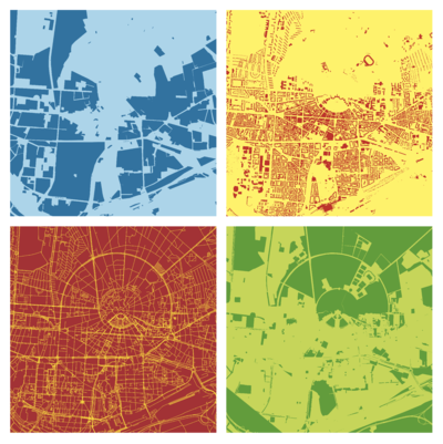
- English : This striking pop-art style image was created by @leopardengruen using OpenStreetMap data from Karlsruhe. It took 4th place in the SOTMEU poster competition
- 中文(繁體) : 這個引人注目的pop風格圖片,由 @leopardengruen 製作,用到來自Karlsruhe的OpenStreetMap圖資。這張圖得到SOTMEU 壁報比賽的第四名。
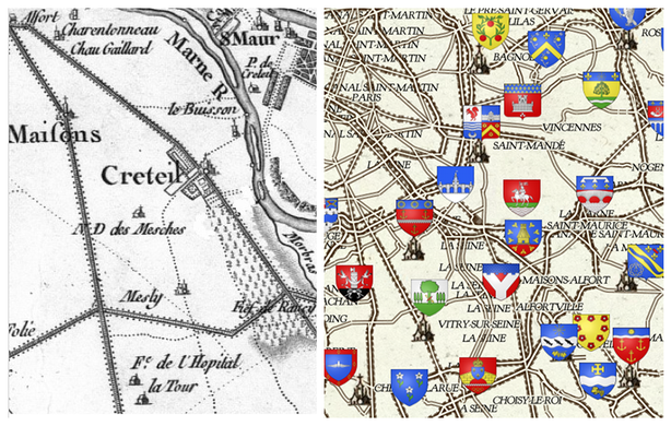
第28週(從2014年7月7日星期一到2014年7月13日星期日) [Edit]

- English : Frédéric Rodrigo developed a stylisation of OpenStreetMap data designed to mimic the classic 18th century french maps by Cassini (shown on the left). You can browse a full map of France in this style, on a site developed for the Heraldry wikipedia project. Frédéric also won 3rd place in the SOTMEU poster competition with a poster-sized print of this map
- 中文(繁體) : Frédéric Rodrigo 開發的開放街圖樣式,模仿經典的 18 世紀 Cassini 設計的法國地圖(左圖)。這套樣式用在 Heraldry 維基計畫,你可以瀏覽該樣式下全法國的地圖樣貌。Frédéric 印出海報大小的該樣式地圖,拿下SOTMEU 海報競賽的第三名。
第29週(從2014年7月14日星期一到2014年7月20日星期日) [Edit]

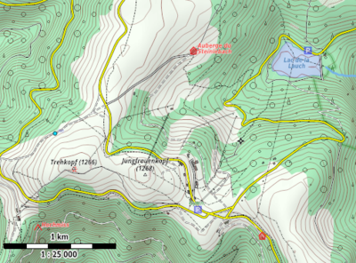
- English : A sample area rendered in the R25 Maperitive style, which was designed by User:JBacc. It works best rendering hi resolution paper maps at approximately 1:25000 map scale, as he demonstrated with his entry coming 2nd place in the SOTMEU poster competition
- 中文(繁體) : User:JBacc 設計的 R25 Maperitive 地圖樣式範本,這種樣式最適合渲染出 1:25000 比例尺的高解析度紙本地圖,因此得到SOTMEU 壁報競賽第二名。
第30週(從2014年7月21日星期一到2014年7月27日星期日) [Edit]

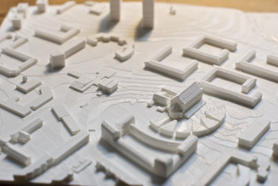
- English : 3D printed model of the Gorbals, Glasgow, location of the Commonwealth games 2014. Created using osm2world to convert from .osm to 3D and SRTM elevation data. Printed using a Ultimaker 2.
- 中文(繁體) : 位在格拉斯哥 GorbalsCommonwealth games 2014 的場地,用 3D 列印模型呈現。3D 列印所需的資料使用 osm2world 將 .osm 檔轉成 3D 和 SRTM 高度資料,然後用 Ultimaker 2 列印。
第31週(從2014年7月28日星期一到2014年8月3日星期日) [Edit]

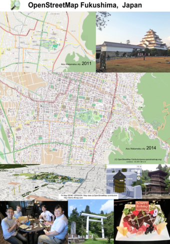
- English : This poster by the Fukushima, Japan, OpenStreetMap community was the winner of the SOTMEU poster competition,(download as PDF)
- 中文(繁體) : 這張由日本福島開放街圖社群所做的海報,是SOTMEU 海報競賽優勝作品之一(下載PDF版本)
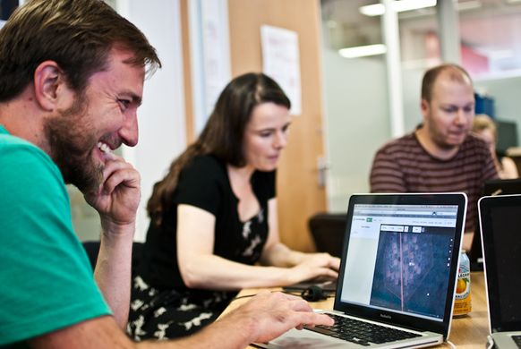
第32週(從2014年8月4日星期一到2014年8月10日星期日) [Edit]

- English : Mapping for fun, and to help with humanitarian aid at the Missing Maps Party in London last week
- 中文(繁體) : 圖客趴很好玩,上週在倫敦辦的Missing Maps Party幫助災難現場從事人道救援工作。
第33週(從2014年8月11日星期一到2014年8月17日星期日) [Edit]

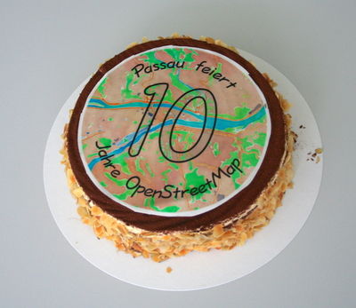
- English : Last weekend we celebrated OpenStreetMap's 10th Birthday in cities all around the world, and (as is now traditional) we had birthday cakes at many of the party locations, such as this one in Passau, Germany
- 中文(繁體) : 上週社群在全球各地舉辦開放街圖十年週慶活動,當然(如今是傳統)我們也有準備生日蛋糕,像是圖中在德國帕紹 會場的蛋糕。
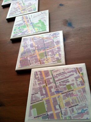
第34週(從2014年8月18日星期一到2014年8月24日星期日) [Edit]

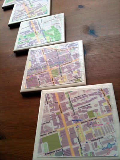
- English : Cake is good. And so are map tiles. Toronto mappers made coasters from maps and ceramic tiles. The coasters safely supported the beverages consumed at the Toronto 10th OSM Birthday celebration, and then attendees were each able to take home the commemorative coasters in addition to the ones that they made.
- 中文(繁體) : 有蛋糕可享用很好,如果有地圖圖磚也不錯。多倫多的圖客利用地圖和陶磁製作杯墊,剛好用在多倫多OSM十週年慶祝活動,安全無無虞的承受消耗的酒量,參與者也能將具有紀念價值的杯墊帶回去,而且還是自己做得噢。
第35週(從2014年8月25日星期一到2014年8月31日星期日) [Edit]

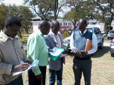
- English : Malawi government officials learning how to create maps with OpenStreetMap. The Humanitarian OpenStreetMap Team have sent a field team to Malawi to run training courses in mapping techniques and also integrating OpenStreetMap into their open GIS data portal. Read more on the HOT blog
- 中文(繁體) : 馬拉威政府官員學習如何用開放街圖繪製地圖。人道開放街圖救難小組派遺在地小組到馬拉威,開設關於繪圖技術的訓練課程,以及協助導入開放街圖到馬拉威他們自己的開放GIS資料入口站。到HOT小組部落格瞭解詳情
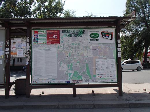
第36週(從2014年9月1日星期一到2014年9月7日星期日) [Edit]

- English : Printed street maps from OpenStreetMap seen in several bus stops around Bishkek, the capital of Kyrgyzstan
- 中文(繁體) : 吉爾吉斯共和國首都比斯凱克的不少公車站牌,可以看到運用開放街圖製作的街道地圖。
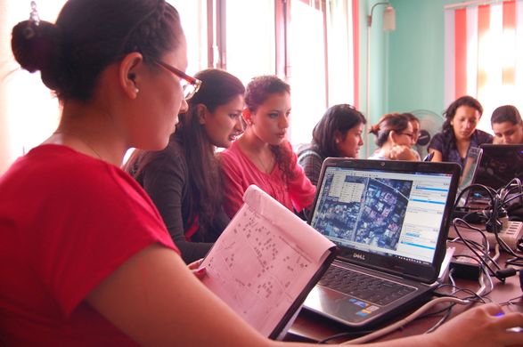
第37週(從2014年9月8日星期一到2014年9月14日星期日) [Edit]

- English : About two dozen women participated in a "Girl’s Mapping Party" organised by Kathmandu Living Labs in Nepal/Kathmandu. Read more on the blog
- 中文(繁體) : 在 尼伯爾/加德滿都,差不多為數兩打的女性參與由 Kathmandu Living Labs 舉辦的「女孩圖客松」。詳情請見部落格文章
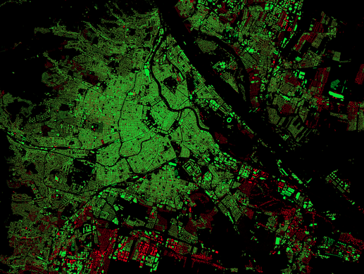
第38週(從2014年9月15日星期一到2014年9月21日星期日) [Edit]

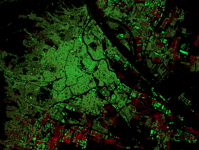
- English : A striking dark-background rendering of OpenStreetMap building coverage (green) and those which are missing (red) as compared to basemap.at data in Austria. Blog post and slippy map
- 中文(繁體) : 一張黑色背景,對比相當強烈的開放街圖建築物覆蓋情形 (綠色),而其他還未畫上去的建築 (紅色),用的是奧地利 basemap.at 的資料比對。 部落格文章和互動地圖
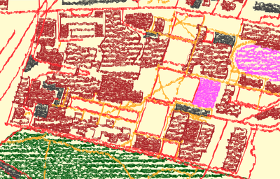
第39週(從2014年9月22日星期一到2014年9月28日星期日) [Edit]

- English : The OpenStreetMap Crayon Style. Browse a slippy map here. This playful use of map data is rendered with JavaScript and HTML5 canvas. source and more details
- 中文(繁體) : 蠟筆風格的開放街圖。在這邊瀏覽滑溜地圖。這套地圖使用 JavaScript 和 HTML5 canvas。原始碼及更多細節