Zh-hant:Featured images/Oct-Dec 2017
Jump to navigation
Jump to search


這是特色圖片,展現開放街圖畫地圖範例,以及最能代表開放街圖的專案。
如果你知道其他有類似品質的圖片,你可以在特色圖片提名處(en)提名。
| ← 從2016年10月到12月 | ← 從2017年7月到9月 | 從2018年1月到3月 → | 從2018年10月到12月 → |
特色圖片庫、從2017年10月到12月

2017年、第40週
2017年、第41週

2017年、第42週

2017年、第43週

2017年、第44週

2017年、第45週
2017年、第46週
2017年、第47週

2017年、第48週

2017年、第49週
2017年、第50週
2017年、第51週
2017年、第52週
細節和字幕
第40週(從2017年10月2日星期一到2017年10月8日星期日) [Edit]

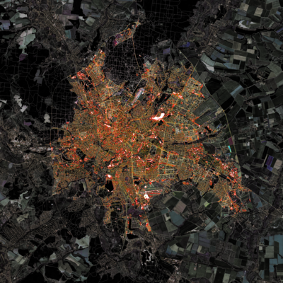
- English : An automatically generated spectrum of urban development patterns for around 1 million cities, towns and villages across the planet. Image from Vahid Moosavi's paper “Urban morphology meets deep learning” (PDF).
- 中文(繁體) : 一個自動產生,大約一百萬人尺度的全球城市、城鎮和村莊發展圖譜。圖片來源是 Vahid Moosav 的論文 “Urban morphology meets deep learning” (PDF)。
第41週(從2017年10月9日星期一到2017年10月15日星期日) [Edit]

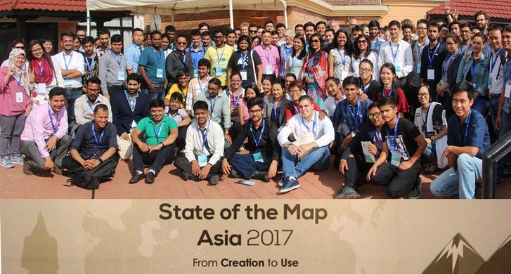
- English : Different OSM communities across Asia came together at the State of the Map Asia 2017 conference that took place in Kathmandu, Nepal from September 23 to 24th.
- 中文(繁體) : 9 月 23~24 日在尼泊爾加德滿都舉行的 State of the Map Asia 2017 大會聚集亞洲各地的 OSM 社群成員一同參與。
第42週(從2017年10月16日星期一到2017年10月22日星期日) [Edit]

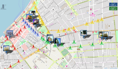
- English : The PRODEPA state agency created an online map of the city of Belém, State of Pará, Brazil, showing the location of a dozen of processions, and of points of interest, temporary medical facilities and blocked streets, for the “Círio de Nazaré” religious festival, gathering more than 2 million people during 2 weeks in October 2017.
- 中文(繁體) : PRODEPA 州政府機構為巴西帕拉州貝倫市創建線上地圖,顯示“Círio de Nazaré”宗教盛會遊行路線、興趣點,臨時醫療機構和封鎖的街道。這次活動 2017 年 10 月兩週活動期間,吸引超過兩百萬的民眾參與。
第43週(從2017年10月23日星期一到2017年10月29日星期日) [Edit]

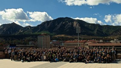
- English : Last weekend State of the Map U.S. 2017 took place in Boulder, Colorado.
- 中文(繁體) : 上週 State of the Map U.S. 2017 在美國科羅拉多州波德舉行。
第44週(從2017年10月30日星期一到2017年11月5日星期日) [Edit]

- English : Gontsa is creating a series of images merging OpenStreetMap data on top of Landsat satellite imagery. This image shows Kharkiv, Ukraine, during the autumn. You can see other works of Gontsa on his Instagram page.
- 中文(繁體) : Gontea創造一列列運用開放街圖資料與疊上 Landsat 衛星影像的圖片。這張圖顯示烏克蘭卡爾可夫秋天的圖像。更多圖片可到Gontea 的 Instagram 頁面觀賞。
第45週(從2017年11月6日星期一到2017年11月12日星期日) [Edit]

- English : An award given to the (Swiss) OpenStreetMap longterm contributors, presented at the DINAcon 2017 conference in Bern on digital sustainability.
- 中文(繁體) : 在伯恩舉行的 DINAcon 2017 大會時,為表彰數位永續行動,向(瑞士)開放街圖長期貢獻者頒發獎章。
第46週(從2017年11月13日星期一到2017年11月19日星期日) [Edit]

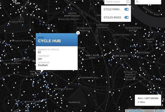
- English : A map made by Stolen Ride shows every London cycle parking location mapped on OpenStreetMap and an optional layer of police data with the places of reported stolen bikes.
- 中文(繁體) : Stolen Ride 製作的地圖顯示每個畫上開放街圖的倫敦單車停車位置,以及可以選擇打開的圖層,顯示警方的被竊單車報告位置。
第47週(從2017年11月20日星期一到2017年11月26日星期日) [Edit]

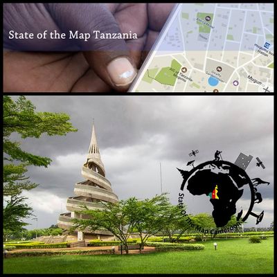
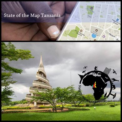
- English : December 2017 will see two State of the Map conferences in African countries! 1st-3rd, SotM Cameroon will be held in Yaoundé, and 8th-9th SotM Tanzania is in Dar es Salaam.
- 中文(繁體) : 2017 年 12 月有兩場在非洲國家舉行的 State of the Map 大會!1~3 日時在SotM Cameroon 在雅溫德舉行,而 8~9 日則是在三蘭港舉行的 SotM Tanzania
第48週(從2017年11月27日星期一到2017年12月3日星期日) [Edit]

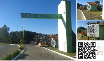
- English : The town hall of Ribeirão Grande, Brazil, put in the town entrance a map based on OpenStreetMap data, and a big QR code (containing the string
geo:-24.09498,-48.36436?z=19, an URI for representing its geographic location, based on the standard scheme proposed in RFC 5870). - 中文(繁體) : 巴西大里貝朗的市鎮廳入口處,有個用開放街圖資料為基礎的地圖,以及大大的 QR code (含有字串
geo:-24.09498,-48.36436?z=19,基於RFC 5870提出的標準格式網址表示這裡的地理位置)
第49週(從2017年12月4日星期一到2017年12月10日星期日) [Edit]

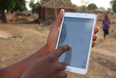
- English : Missing Maps data being used in a flood preparedness mission in Malawi, by the Malawi Red Cross Society and the Netherlands Red Cross. Information (building=*) on building quality and materials is added to OpenStreetMap to facilitate an efficient future aid response.
- 中文(繁體) : 在馬拉威紅十字會和荷蘭紅十字會的活動上,Missing Maps 資料被用在馬拉威水災災前準備的任務。關於建築品質和材料的 (building=*) 資訊被加到開放街圖上面,以協助未來有效的救災援助行動。
第50週(從2017年12月11日星期一到2017年12月17日星期日) [Edit]

- English : Richard Folly visiting Fatima Alher and the OSMGirls, a multilingual mapping group of young African women (based in Comoros, Côte d'Ivoire, France, Ghana, Madagascar, Malawi, Mozambique, Niger, South Africa, Tanzania, Togo and Uganda).
- 中文(繁體) : Richard Folly 拜訪 Fatima Alher 以及由(根基於喀麥隆、象牙海岸、法國、嘉納、馬達加斯加、馬拉威、莫三比克、奈吉利亞、南非、坦尚尼亞、東加和烏干達) 女性組成的 OSMGirls。
第51週(從2017年12月18日星期一到2017年12月24日星期日) [Edit]

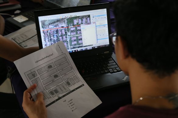
- English : Regular mapping event “Mapping Yangon” at Phandeeyar Myanmar Innovation Lab added on OpenStreetMap the street names, health centers and public locations of Dala township, Yangon region, Myanmar.
- 中文(繁體) : 在 Phandeeyar Myanmar Innovation Lab 平時進行的仰光畫地圖活動,在開放街圖增加緬甸仰光區域德拉區的街道名稱、健康設施以及公共設施。
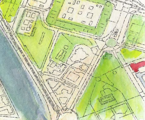
第52週(從2017年12月25日星期一到2017年12月31日星期日) [Edit]

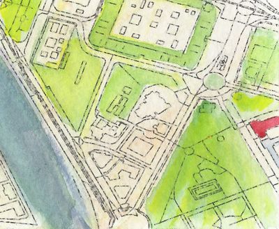
- English : Detail from a watercolour map of Seville, created by Andrew McGuire as a Christmas present for his wife. Hand-painted upon an OpenStreetMap base-map via Mapzen.
- 中文(繁體) : Andrew McGuire 製作的塞維亞詳細水墨畫地圖,是給他太太的耶誕節禮物,依據 Mapzen 基於開放街圖資料手繪製作。