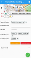
Every Door
| Every Door | |
|---|---|
 | |
| Author: | Ilya Zverev |
| License: | ISC License (free of charge) |
| Platforms: | iOS 12+ and Android 5.0+ |
| Version: | 5.1 (2024-05-29) |
| Language: | English |
| Website: | https://every-door.app |
| Install: | |
| Source code: | zverik/every_door |
| Programming language: | Dart |
|
Power mapper's mobile editor for maintaining amenities on OSM. | |
Every Door is an Android and iOS app that lets you create and edit objects in OpenStreetMap. It supports editing node and polygon features, and creating point features like shops, benches, and building entrances. The source code is published under the open ISC license on GitHub.
This application is designed specifically to help users keep amenities and shops up-to-date and perform detailed micro-mapping.
Features
- Display OSM raster map and Bing aerial view
- Create/Update/Delete POI
- Create/Update/Delete houses addresses
- 3 editing modes:
- Amenities/shop mode
- Addresses mode
- Features near you mode
- Connection on OSM through OAuth (or login/password)
- Left hand compatible
- Support different aerial imagery (Bing, BDOrtho IGN, Cadastre, Esri, Mapbox Satellite, …)
Development/Translation
Help is welcome for development and translation, please find all the info on the GitHub repository.
Gallery

Aerial view

Adding a Shop
Edit vending machine
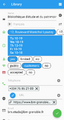
Edit a library
Edit library tags

Near addresses mode

Near feature mode

Options


Functionality
As currently there is no documentation for EveryDoor, this section holds functionality description snippets.
Getting started
Logging in
EveryDoor allows to collect data without logging in. If you intend to go for a survey and want to upload soon - for example, to avoid editing conflicts - make sure to log in right away, if your OSM credentials are stored in a password manager that is not accessible from your phone.
To log in, open menu -> OSM Account -> Log in with OAuth.
Alternatively, EveryDoor will prompt for login the first time data upload is attempted.
Downloading data
When EveryDoor is first opened, or positioned in a location with no downloaded data, a red bar No data, tap here to download will appear. Tapping it will download OSM data. Data is downloaded in a larger region, not just the immediate viewport to avoid frequent downloads when moving.
If there is downloaded data, but it is outdated, a yellow bar Data is obsolete, tap here to refresh will appear.
[TODO] What area is downloaded, does zoomlevel affect this? [TODO] How old is "obsolete"? [TODO] What happens if "obsolete" overlaps with "fresh" in the current area to downloaded, can "fresh" data prevent "obsolete" from being updated, or does it re-download the whole are if any element is considered "obsolete"?
Moving nodes
To move a node, tap on a POI in the detail pane (at the bottom).
Then tap anywhere in the map (at the top). It has a "Move" label next to the POI, but tapping anywhere in the map will allow to move the selected POI.

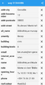
History
- 8 July 2021: "AmenityEditor" is announced at the State of the Map[1].
- 22 October 2021: The development has started.
- 7 December 2021: First changeset in the Sandbox.
- 25 March 2022: Start of internal testing and first edits to OSM.
- 11 May 2022: Start of open testing.
- 15 August 2022: Version 1.0 is published at AppStore and Google Play.
- Sep 9, 2022: Release of Version 2.0
- Oct 25, 2022: Release of Version 3.0
- End of 2022: Every Door gets accepted to the F-Droid store.
- October 2023: Version 4.0; publishing to Huawei AppGallery.
- May 2024: Version 5.0, GeoScribble support.
See also
- Introduction video by Ilya Zverev on YouTube
- GeoMob podcast episode about the editor
- TDT Webinar on mapping with Every Door
- Talk on making the editor from SotM 2022
- Two-hour mapping session in Tallinn