DE:Featured images/Apr-Jun 2017
< DE:Featured images(Redirected from DE:Featured Images/Apr-Jun 2017)
Jump to navigation
Jump to search

Hier sind die vorgestellten Bilder zu sehen. Die Bilder wurden als Vorzeigebeispiele des OpenStreetMap-Projektes auserwählt.
Wenn du ein Bild hast, welches als Bild der Woche sein könnte, dann kannst du es hier auf der (en) Vorschläge des ausgewählten Bildes-Seite vorschlagen.
| ← von April bis Juni 2016 | ← von Januar bis März 2017 | von Juli bis September 2017 → | von April bis Juni 2018 → |
Galerie der vorgestellten Bilder, von April bis Juni 2017
2017, Woche 14
2017, Woche 15
2017, Woche 16
2017, Woche 17
2017, Woche 18
2017, Woche 19
2017, Woche 20
2017, Woche 21
2017, Woche 22
2017, Woche 23
2017, Woche 24
2017, Woche 25
2017, Woche 26
Details und Beschriftungen
Woche 14 (von Montag, 3. April 2017 bis Sonntag, 9. April 2017) [Edit]

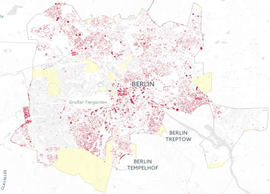
- English : Illustrating the scale of destruction in Aleppo, Syria, by reprojecting it onto OpenStreetMap buildings of Berlin: hanshack.com.
- Deutsch : Veranschaulichung der Zerstörungen in der syrischen Stadt Aleppo durch Reprojektion auf die OpenStreetMap-Gebäudedaten von Berlin: hanshack.com.
Woche 15 (von Montag, 10. April 2017 bis Sonntag, 16. April 2017) [Edit]

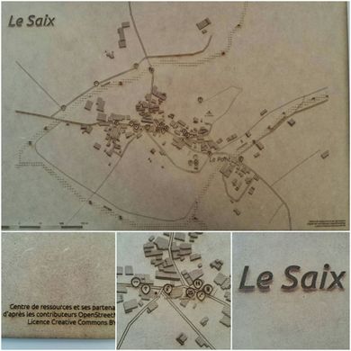
- English : The village of Le Saix (Hautes-Alpes, France) mapped in OpenStreetMap [1] and printed with a laser cutter. A collaboration between Centre de ressources, Apitux, Camille Bissuel and Planète Champsaur, made in Fab'Alpes in Gap.
Woche 16 (von Montag, 17. April 2017 bis Sonntag, 23. April 2017) [Edit]

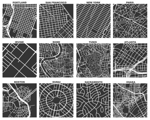
- English : Geoff Boeing created OSMnx, a tool which uses OSM data to compare street networks and urban forms. In the image you can see one square mile extracts of some city centers around the world. Read more about Geoff's work on his blog.
Woche 17 (von Montag, 24. April 2017 bis Sonntag, 30. April 2017) [Edit]

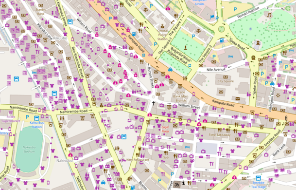
- English : In 2017 we will have the first ever State of the Map Africa! It will be held in Kampala, Uganda’s capital, from 8th to 10th July. Here we see the well mapped Kampala city centre.
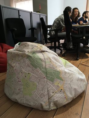
Woche 18 (von Montag, 1. Mai 2017 bis Sonntag, 7. Mai 2017) [Edit]

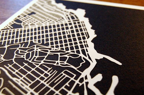
- English : Kartegraphik has been doing handmade papercut maps based on OpenStreetMap data. This image is a map of Monterey, California. See more at kartegraphik.com.
- Deutsch : Kartegraphik hat handgemachte Papierschnittkarten aus OpenStreetMap-Daten erstellt. Dieses Bild zeigt eine Karte von Monterey in Kalifornien. Mehr dazu unter kartegraphik.com.
Woche 19 (von Montag, 8. Mai 2017 bis Sonntag, 14. Mai 2017) [Edit]

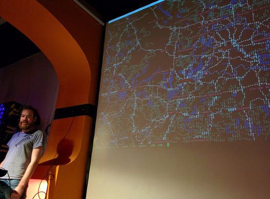
- English : A presentation of mapscii [2], a zooming panning view of OpenStreetMap rendered as ASCII art (also including Braille dot patterns).
Woche 20 (von Montag, 15. Mai 2017 bis Sonntag, 21. Mai 2017) [Edit]

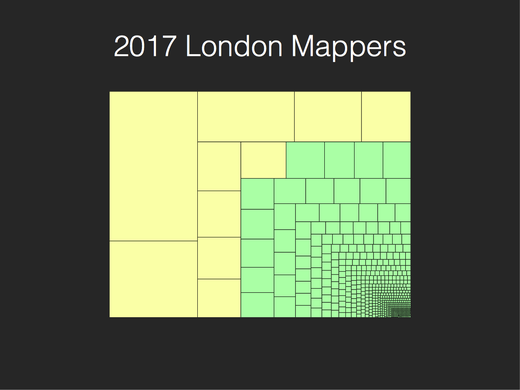
- English : The top ten mappers (yellow) account for most of the data contributed in London so far in 2017. Andy Allan presented "Who is mapping London?" at the recent OSM Q&A event.
Woche 21 (von Montag, 22. Mai 2017 bis Sonntag, 28. Mai 2017) [Edit]

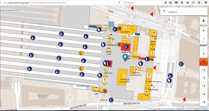
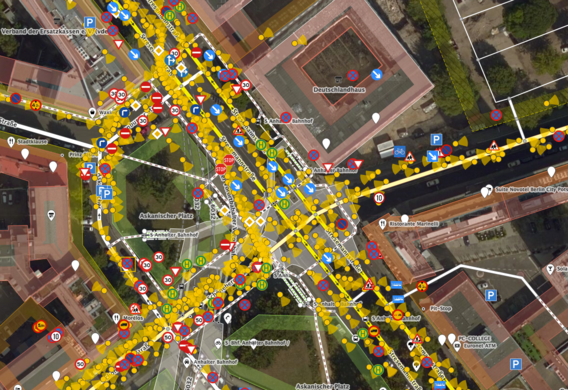
- English : Large railway stations often include shops and other features inside them. OpenStationMap (openstationmap.org) reveals indoor mapping data (where it has been added) specifically for railway stations.
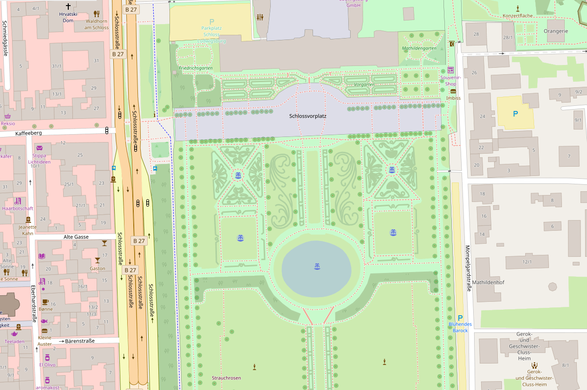
Woche 22 (von Montag, 29. Mai 2017 bis Sonntag, 4. Juni 2017) [Edit]

- English : Nammala from the Mapbox data team gave a round-up of some recent interesting edits, mostly vandalism detected using osmcha, but also this very detailed mapping of the Gardens of Ludwigsburg Palace made by Paddy1984.
Woche 23 (von Montag, 5. Juni 2017 bis Sonntag, 11. Juni 2017) [Edit]
.jpg)
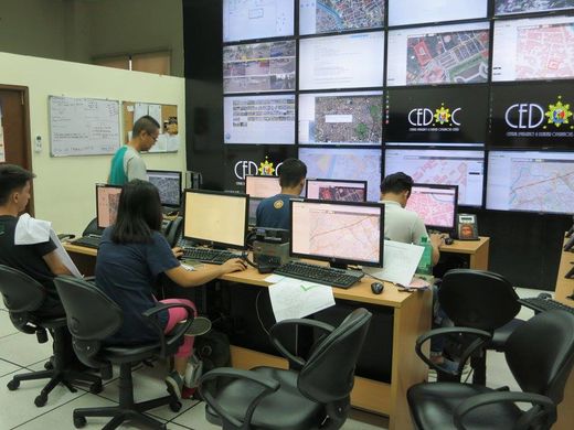
- English : Mapathons can be made more fun and interesting when your work is displayed on a wall of monitors for everyone to see! This mapathon, supported by the OSM Philippines community, was organized by User:GOwin as part of his MapAmore initiative and was hosted by the City of San Juan's Central Emergency and Disaster Operations Center (CEDOC).
Woche 24 (von Montag, 12. Juni 2017 bis Sonntag, 18. Juni 2017) [Edit]

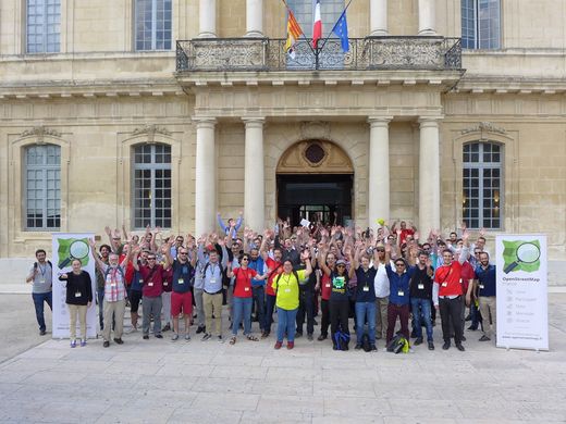
- English : Some of the 250 attendees of State of the Map France 2017, which took place 2–4 June in Avignon.
- Deutsch : Einige der 250 Teilnehmer der State of the Map France 2017, die vom 2. bis 4. Juni in Avignon zu Gast war.
Woche 25 (von Montag, 19. Juni 2017 bis Sonntag, 25. Juni 2017) [Edit]

- English : The iD editor showing a new data layer from Mapillary, with road signs detected within the street-level imagery.
- Deutsch : The iD editor showing a new data layer from Mapillary, with road signs detected within the street-level imagery.
Woche 26 (von Montag, 26. Juni 2017 bis Sonntag, 2. Juli 2017) [Edit]
