DE:Featured images/Jan-Mar 2017
< DE:Featured images(Redirected from DE:Featured Images/Jan-Mar 2017)
Jump to navigation
Jump to search

Hier sind die vorgestellten Bilder zu sehen. Die Bilder wurden als Vorzeigebeispiele des OpenStreetMap-Projektes auserwählt.
Wenn du ein Bild hast, welches als Bild der Woche sein könnte, dann kannst du es hier auf der (en) Vorschläge des ausgewählten Bildes-Seite vorschlagen.
| ← von Januar bis März 2016 | ← von Oktober bis Dezember 2016 | von April bis Juni 2017 → | von Januar bis März 2018 → |
Galerie der vorgestellten Bilder, von Januar bis März 2017
2017, Woche 1
2017, Woche 2
2017, Woche 3
2017, Woche 4
2017, Woche 5
2017, Woche 6
2017, Woche 7
2017, Woche 8
2017, Woche 9
2017, Woche 10
2017, Woche 11
2017, Woche 12
2017, Woche 13
Details und Beschriftungen
Woche 1 (von Montag, 2. Januar 2017 bis Sonntag, 8. Januar 2017) [Edit]

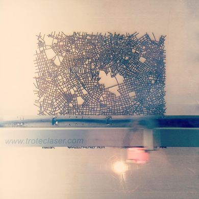
- English : The Mable is a map table, an experimental product featuring OpenStreetMap streets laser-etched into a table top design.
- Deutsch : Der Mable ist ein Kartentisch, ein experimentelles Produkt, bei dem mit einem Laser Straßen aus OpenStreetMap in die Tischoberfläche geätzt sind.
Woche 2 (von Montag, 9. Januar 2017 bis Sonntag, 15. Januar 2017) [Edit]

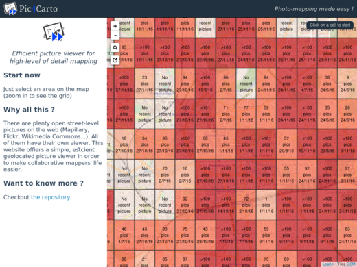
- English : Pic4Carto helps to find useful street-level photos as a source for OpenStreetMap mapping. It shows a grid with the number of open licensed photos to be found in an area.
Woche 3 (von Montag, 16. Januar 2017 bis Sonntag, 22. Januar 2017) [Edit]

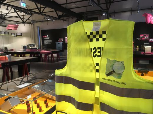
- English : An OpenStreetMap jacket on show at a “Who makes the map” exhibition at the German Museum of Technology.
- Deutsch : Eine OpenStreetMap-Warnweste in der Ausstellung »Who makes the map« des Deutschen Technikmuseums.
Woche 4 (von Montag, 23. Januar 2017 bis Sonntag, 29. Januar 2017) [Edit]

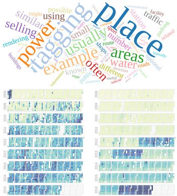
- English : OSMvis is a collection of visualizations related to OpenStreetMap. Top: Most frequent words in the OSM Wiki. Left: Daily amount of new nodes. Right: Number of new users per day. See more visualizations at http://projects.mocnik-science.net/osm-vis/.
- Deutsch : OSMvis ist eine Sammlung von Visualisierungen rund um OpenStreetMap. Oben: Die häufigsten Wörter im OSM-Wiki. Links: Anzahl neuer Nodes pro Tag. Rechts: Anzahl neuer Benutzer pro Tag. Weitere Visualisierungen sind verfügbar auf http://projects.mocnik-science.net/osm-vis/.
Woche 5 (von Montag, 30. Januar 2017 bis Sonntag, 5. Februar 2017) [Edit]

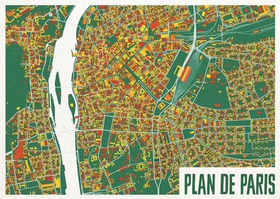
- English : A colourful map from ateljekartan.com. A variety of interesting colour choices are available there to use for ordering poster prints.
(but can you spot the mistake in this image?) - Deutsch : Eine farbenfrohe Karte von ateljekartan.com. Eine Vielzahl an interessanten Farbschemata steht für die Bestellung von Posterdrucken zur Auswahl.
(PS: Findest du den Fehler?)
Woche 6 (von Montag, 6. Februar 2017 bis Sonntag, 12. Februar 2017) [Edit]

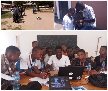
- English : High school students in Bagamoyo, Tanzania, being taught how to gather data and input add to OpenStreetMap, by the Ramani Huria team. Read more on the ramanihuria.org blog.
- Deutsch : Schüler einer Highschool in Bagamoyo, Tansania, lernen vom Ramani-Huria-Team das das Sammeln von Daten und Verbessern von OpenStreetMap. Mehr dazu im Blog ramanihuria.org.
Woche 7 (von Montag, 13. Februar 2017 bis Sonntag, 19. Februar 2017) [Edit]

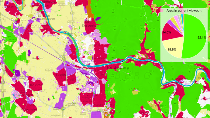
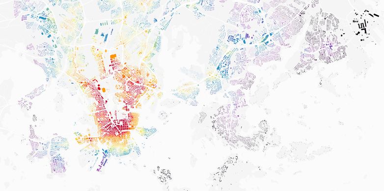
- English : OSMLanduse.org highlights OpenStreetMap's rich landuse/landcover data. The strikingly colourful map shows how our wide range of landcover tags can be broadly classified and analysed.
- Deutsch : OSMLanduse.org hebt die reichhaltigen landuse/landcover-Daten von OpenStreetMap hervor. Die bemerkenswert farbige Karte demonstriert, wie unsere Vielfalt an Landcover-Tags grob klassifiziert und analysiert werden kann.
Woche 8 (von Montag, 20. Februar 2017 bis Sonntag, 26. Februar 2017) [Edit]

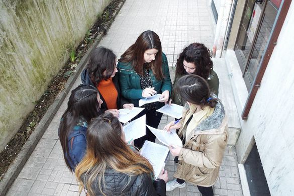
- English : OSM Mapathon at OpenLabs Albania, a hackerspace in the city of Tirana that are organizing a lot of activities related to OpenStreetMap, Wikipedia and FLOSS. In that mapathon they used FieldPapers.
- Deutsch : OSM Mapathon im OpenLabs Albania, einem Hackerspace in der Stadt Tirana, wo viele Aktivitäten rund um OpenStreetMap, Wikipedia und freie Software organisiert werden. Bei diesem Mapathon kamen FieldPapers zum Einsatz.
Woche 9 (von Montag, 27. Februar 2017 bis Sonntag, 5. März 2017) [Edit]

- English : Lauri Vanhala took OpenStreetMap buildings in Helsinki, analysed the location of jobs and travel times from every building, and produced this map to help decide the best place to live. Browse the full map and read more on this blog.
- Deutsch : Lauri Vanhala produzierte mithilfe der Gebäudedaten in OpenStreetMap eine Karte, um herauszufinden, wo man in Helsinki am besten leben kann. Dazu analysierte er die Fahrzeiten zum Arbeitsort von jedem Gebäude aus. Sieh die Karte an and lies mehr darüber in diesem Blogpost.
Woche 10 (von Montag, 6. März 2017 bis Sonntag, 12. März 2017) [Edit]

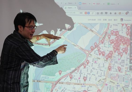
- English : Discussing river area mapping, and Notes at the OpenStreetMap Taipei meet-up. Regular events are listed on the OpenStreetMap Taiwan facebook group.
- Deutsch : Auf dem OpenStreetMap-Treffen in Taipeh wird über Flussflächenmapping und Notes diskutiert. In der Facebook-Gruppe von OpenStreetMap Taiwan werden regelmäßig Events angekündigt.
Woche 11 (von Montag, 13. März 2017 bis Sonntag, 19. März 2017) [Edit]

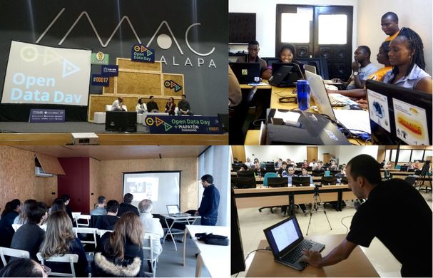
- English : March 4th was OpenDataDay and people all over the world organized small events to talk about and produce Open Data. In a lot of places we had OpenStreetMap activities, like mapping parties, mapathons and talks. Here you can see events in Xalapa (Mexico), Cotonou (Benin), Porto (Portugal) and Brasília (Brazil).
- Deutsch : Am 4. März war OpenDataDay. Menschen in aller Welt haben Veranstaltungen organisiert, um über Open Data zu diskutieren und selbst einen Beitrag zu leisten. An vielen Orten gab es OpenStreetMap-Aktivitäten wie Mappingparties, Mapathons und Vorträge. Zu sehen sind die Events in Xalapa (Mexico), Cotonou (Benin), Porto (Portugal) und Brasília (Brasilien).
Woche 12 (von Montag, 20. März 2017 bis Sonntag, 26. März 2017) [Edit]

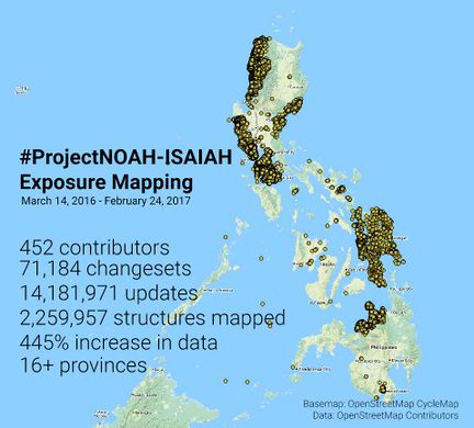
- English : The Nationwide Operational Assessment of Hazards (NOAH) coordinated a series of mapping sessions in the last 12 months that improved the map of Philippines. This data will be used in improving disaster management before, during, and after emergencies. Read more on the NOAH blog.
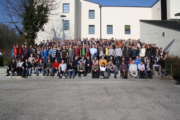
Woche 13 (von Montag, 27. März 2017 bis Sonntag, 2. April 2017) [Edit]

- English : FOSSGIS 2017, the German OpenStreetMap and open source GIS conference, took place last week in Passau.
- Deutsch : FOSSGIS 2017, die Konferenz zu OpenStreetMap und freier GIS-Software für den deutschsprachigen Raum, fand letzte Woche in Passau statt.