FR:Yahoo! Aerial Imagery
![]()

- Captured time
- 2010, 2019 (#Coverage)


Yahoo! fournit des photographies aériennes verticales dans son interface cartographique (un service parmi d'autres similaires). Toutefois, Yahoo! a accepté que OSM utilise son imagerie aérienne (l'annonce sur le blog OpenGeoData) pour le traçage. Il est possible d'utiliser l'un des trois principaux éditeurs OSM (Potlatch, Merkaartor, ou JOSM), pour modifier les données cartographiques OSM sur un fond d'imagerie Yahoo!. Pour JOSM, il faut installer le greffon WMS pour accéder au WMS Yahoo!.
Informations légales
L'accord permet de dériver les données cartographiques vectorielles des photos aériennes appartenant à Yahoo! et de diffuser ces œuvres dérivées avec la licence OpenStreetMap (sans copyright Yahoo!). Il est autorisé d'afficher les photos aériennes avec les données OSM dans Potlatch et l'applet Java (et tout outil de cartographie online), et également maintenant d'utiliser des greffons dans JOSM (depuis le 13 juillet 2007 - Voir le message dans la liste). Des utilisations similaires dans d'autres outils de cartographie off-line seraient probablement aussi autorisé, mais les développeurs peuvent vouloir discuter les détails avant de commencer à dépenser beaucoup de temps dans de nouveaux développements.
La dernière annonce de Yahoo sur le côté légal, par l'intermédiaire de Scott Regan, est :
Sur l'utilisation de nos API [NdT : interfaces de programmation] aériennes, je peux encore réaffirmer que l'utilisation par OSM des API gratuites pour superposer GPS et tracés semble bien conforme au conditions d'utilisation.
Pour répondre à d'autres questions qui ont été posées, nous ne voyons aucun problème [NdT : litt. « aucun drapeau rouge »] avec l'approche de superposition de fichiers GPX qui est utilisée par la communauté OSM au regard de notre restriction sur le suivi de coordonnées GPS en temps réel ou de points de moins de 6 heures d'ancienneté. Et votre autre question sur le mécanisme de cache de l'imagerie de façon transparente par l'application de traçage OSM ne viole pas non plus la contrainte qui empêche de capturer des images individuelles pour un objectif commercial. Encore une fois, notre affirmation est que vous êtes conforme au conditions d'utilisation.
J'espère que cela permettra de répondre à quelques préoccupations de la communauté, merci de continuer à nous faire savoir comment nous pouvons vous aider au fur et à mesure de l'avancement.
Mikel a travaillé sur le lien avec les gens de chez Yahoo! à propos de cet accord. Son commentaire est :
- « Même si il reste des questions, je suggère que nous continuions comme nous l'avons fait en toute confiance. OSM continue même avec les questions restantes sur l'attribution, etc. L'utilisation de l'imagerie Yahoo! peut continuer. Le principe de ce que nous faisons est clair, il n'y a que des détails qu'il reste à fixer. »
Nous n'avons pas d'accord écrit expliquant exactement ce qui est autorisé. Il semble qu'il suffise de se mettre d'accord sur une interprétation de leurs conditions d'utilisation.
- Toujours selon Mikel: « Il y a beaucoup d'individus, de chefs de projet et de juristes, impliqués dans la décision. La première passe sur le sujet fut une lecture plus attentive des conditions d'utilisation, mais à la demande, ils (Yahoo) ont investi un temps significatif pour ré-examiner les détails. »
Utiliser l'imagerie aérienne Yahoo!
L'accord avec Yahoo pourrait simplifier considérablement le processus cartographique. Avant nous partions d'un cadre vierge. Nous n'avions pas d'informations libres de copyright (excepté des cartes sans copyright très dépassées) et étions forcés de partir de zéro, parcourant les rues avec nos récepteurs GPS. Maintenant, en utilisant les photos aériennes sur des zones urbaines, nous pourrions commencer à cartographier des zones sans devoir aller là-bas, ce qui fait une différence assez importante !
Malheureusement nous devons de toute façon visiter les rues que nous cartographions, au moins à une certaine étape. Les images aériennes nous donnent le canevas des rues, mais il y a d'autres informations que nous devons récolter ; la plus importante étant les noms des rues. Nous allons être tentés de regarder des cartes existantes, juste pour récupérer les noms de rues, mais nous ne pouvons pas faire ça ! C'est de la copie ! Nous ne pouvons pas faire ça, pour toutes les mêmes raisons que nous ne pouvons pas tracer le canevas des rues d'autres cartes, ou récupérer les latitude/longitude à partir d'autres cartes. Techniquement c'est une violation de copyright, et nous pourrions être sermonnés si nous le faisions. C'est frustrant, mais nous n'avons qu'à aller voir les plaques de rues pour trouver les noms !
Pendant qu'on y est, il y a d'autres informations qu'il faut récolter. Nous devons noter les sens uniques, tous les autres éléments de la légende comme les pubs, les bureaux de poste, qui ne peuvent se voir dans les photos aériennes.
Sketching over the imagery
Working with aerial imagery lends itself to a very different overall mapping approach. It is possible to sketch in the road layout for large expanses of urban areas, without going there. This yields a map which is far from finished (doesn't have street names!) but is also far from a blank slate.
Next somebody (not necessarily the same person) can take a print-out of this road-layout with them (see Walking Papers) as they visit the area. As well as collecting street names, and noting other features. They can also spot corrections which need to be made. Often streets can be obscured from the aerial view. Sometimes it looks like there is a street, when in fact there isn't.
How to sketch?
As described above, mapping can take place in two phases: Sketching and then more complete surveying. However the preferred approach for putting these sketched roads into the database, needs to be decided and clarified (here).
The new Potlatch editor is the easiest way of tracing over the imagery. WMS plugin in in JOSM is an alternative which is a little more fiddly to set up.
In Potlatch you can sketch in untagged ways (a way with no highway= or other such keys set). But if you are sketching roads you should alway use the highway=road at least, which is used for road that are not classified yet (don't mix up with the highway tag "unclassified", which is a certain type of road!).
One problem is that neither Mapnik nor Osmarender (the layer as configured by default and rendered by Tiles@Home) will show totally untagged ways. Maplint shows untagged ways, but it also shows all the other lint, and doesn't show the complete areas of map. This makes it harder to get a quick feel for the level of phase one completeness in an area. It's also harder to get a print-out suitable for use while surveying. Solutions to this might be to screenshot Potlatch with the background imagery switched off (to use less ink) or screenshot JOSM and invert the image to get a white background. More fiddly solutions involve running custom settings of Osmarender, or Kosmos (e.g.), or using an image editor to splice together Maplint with other renderings (Image:Shoho Cake inc segments.png is an example of this)
An alternative might be to set a highway tag, but not a name tag. This is tempting, since your work will show up on the map, however it is not a recommended approach since it will result in areas which appear to be fully mapped, but in fact nobody has done a proper survey. The two-phase approach definitely requires a second phase! Unnamed ways are not sufficiently distinct from named ways in any of the default map layers, as they are currently set up. It might not be feasible to make them more distinct, since some ways will never have 'name' tag even in their finished state (e.g. nameless footpaths)
Landuse
Landuse is usually easy to determine from Yahoo imagery and, in many cases, infeasible to obtain using GPS surveying so it's a good thing to sketch.
Bodies of water, woodland and residential areas all show up really well and are worthwhile to trace. Tracing residential areas is possibly more useful than trying to trace residential roads. A marked residential area with no roads is clearly visible on rendered maps and can help a GPS user to find areas that need detailed surveying.
Yahoo imagery boundaries
It can be useful to others to add a way that defines the boundary of each area of high resolution imagery. The convention is to tag it with something like: note=Extent of Yahoo imagery for London.
There are lists and maps of areas of high resolutions here.
Problems with tracing Yahoo
This section is to list problems with tracing from Yahoo Imagery, and may cause problems with later editing.
- Roads and paths under trees cannot be seen.
- Roads are unnamed, and not easy to classify, so the highway=road tag should be used, until either on the ground classification or someone who knows the area comes and updates the data.
- Roads from the sky look like a t-junction, but in reality are a turn to stay on the road.
- Complex junctions are rarely drawn in a detailed form, which is required for routing or turn restrictions
- Minimal one way restrictions
- Divergence of Yahoo Images from up to 10m (can be solved by adjusting the Image to a GPS trace)
Achievements
The availability of the Yahoo! imagery has made possible a number of tasks which would most be almost impossible without it. Some of these achievements are listed here:
The whole of the original London Congestion Charging Zone was mapped over a single weekend by a team of people using Yahoo! imagery. London is notoriously difficult to map using conventional GPS-based methods due to the urban corridor effect giving poor traces.

- Baghdad maps
The whole road and rail network of the Baghdad area has been mapped using the Yahoo! imagery. As have some parks, forested areas, etc. People on the street are showing real interest in filling in the road names to make this an actually useful map, it's not just a promotion piece.
- Mashhad, Iran
The whole road and rail network of the Mashhad, Iran area has been mapped using the Yahoo! imagery. As have some parks, forested areas, etc. Street and place names are slowly coming in as well. A GPS-track was used to verify that the Yahoo! imagery indeed was accurate and has very little (<2m) offset in that area
- St Albans and surrounding area
Not quite so grand as the above cases, but every last bit of woodland, every golf course, every lake and the main rivers/streams/lakes were mapped, which isn't possible with Landsat and would be very laborious by ground-based surveys.
- Sydney and surrounding area
Completion of the greater metropolitan railway network, completion of the inner city unclassified road network, many arterial major roads that were previously in as stretches here and there, several complex road interchanges not practical to map on the bike, several major rivers (also strangely difficult to map on a bike) and adjusted many problems due to inner city urban canyoning. Plus a good few golf courses, parks and sports pitches. At the AU$160/km2 rate quoted for Australian 2m resolution imagery, that would have cost AU$300,000.
- Darwin to Port Augusta (Australia)
Using the new Potlatch editor the highway between Darwin and Port Augusta (ie the whole of the central North - South Highway), together with the highway to Ayers Rock & the Olgas, has been completed. Most of the imagery is low resolution. (The road has now been surveyed along stretches and has been nudged and tagged accordingly.)
Coverage
The imagery covers the whole of the U.S., but elsewhere it generally covers only rectangular areas around some cities.
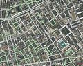
Yahoo! Aerial Imagery presented within the Java Applet editor in 2007 (with early OSM data overlaid)
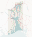
Around Oslo, Norway
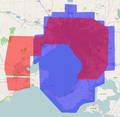
Coverage of Yahoo! (blue) compared to NearMap (red) round Melbourne and Geelong, Australia


Accuracy
Yahoo!'s aerial imagery is pretty accurate. More so than consumer GPS units in general. For more detail see: Yahoo! Aerial Imagery/Accuracy.