File:Überweg (49805422613).jpg
Jump to navigation
Jump to search


Size of this preview: 800 × 600 pixels. Other resolutions: 320 × 240 pixels | 640 × 480 pixels | 1,024 × 768 pixels | 1,280 × 960 pixels | 1,800 × 1,350 pixels.
Original file (1,800 × 1,350 pixels, file size: 1.92 MB, MIME type: image/jpeg)
This file and its description are from Wikimedia Commons.
Summary
| Description |
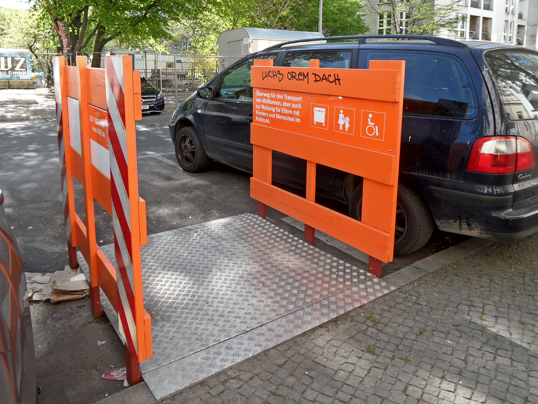
Überweg Graefestraße, Berlin-Kreuzberg, April 2020 Deutsch: Seit 1. August 2018 hat die BSR (Berliner Stadtreinigung) an verschiedenen Stellen der Stadt sogenannte "Überwege" installiert, wo sie - häufig wegen Falschparkern - keinen Zugang mehr zu Häusern hatte, um die Mülltonnen zu leeren.
Nebenbei sind diese Rampen auch für Rollstuhlfahrer, Menschen mit Kinderwagen oder Rollatoren nützlich, wo keine Fußgängerüberwege existieren. |
| Date | |
| Source | Überweg |
| Author | onnola from Berlin / Koblenz (Germany) |
| Camera location | | View this and other nearby images on: OpenStreetMap |
|---|
.jpg¶ms=052.490469_N_0013.415647_E_globe:Earth_type:camera_source:Flickr_&language=en)
Licensing
This file is licensed under the Creative Commons Attribution-Share Alike 2.0 Generic license.
Attribution: onnola from Berlin / Koblenz (Germany)
- You are free:
- to share – to copy, distribute and transmit the work
- to remix – to adapt the work
- Under the following conditions:
- attribution – You must give appropriate credit, provide a link to the license, and indicate if changes were made. You may do so in any reasonable manner, but not in any way that suggests the licensor endorses you or your use.
- share alike – If you remix, transform, or build upon the material, you must distribute your contributions under the same or compatible license as the original.
| This image was originally posted to Flickr by onnola at https://flickr.com/photos/30845644@N04/49805422613. It was reviewed on 4 December 2022 by FlickreviewR 2 and was confirmed to be licensed under the terms of the cc-by-sa-2.0. |
File history
Click on a date/time to view the file as it appeared at that time.
| Date/Time | Thumbnail | Dimensions | User | Comment | |
|---|---|---|---|---|---|
| current | 19:42, 4 December 2022 | | 1,800 × 1,350 (1.92 MB) | wikimediacommons>Chris2ma | Transferred from Flickr via #flickr2commons |
File usage
The following 3 pages use this file:
.jpg)