File:AIROAccessMap airports.png
Jump to navigation
Jump to search


Size of this preview: 800 × 394 pixels. Other resolutions: 320 × 158 pixels | 640 × 315 pixels | 1,416 × 697 pixels.
Original file (1,416 × 697 pixels, file size: 421 KB, MIME type: image/png)
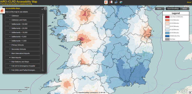
Accessibility to airports in Ireland
http://airomaps.nuim.ie/flexviewer/?config=AIROAccessMap.xml
This is a Featured image, which means that it has been identified as one of the best examples of OpenStreetMap mapping, or that it provides a useful illustration of the OpenStreetMap project. If you know another image of similar quality, you can nominate it on Featured image proposals.
Front-page image for week 9 of 2012 (27 Feb. – 4 Mar.).
- Image descriptions
- English : Travel-time to airports in Ireland: AIRO-ICLRD's Accessibility Map idea chooses OSM as base layer
- français : Temps de transport vers les aéroports en Irlande : AIRO-ICLRD a choisi OSM comme fond de carte pour sa carte d’accessibilité.
- italiano : Tempo di tragitto verso gli areoporti in Irlanda: l'idea della mappa di accessibilità di AIRO-ICLRD si basa su OSM
- 中文(简体) : 爱尔兰机场旅程时间:AIRO-ICLRD的可及性地图采用开放街图当作底层地图
- 中文(繁體) : 愛爾蘭機場旅程時間:AIRO-ICLRD的可及性地圖採用開放街圖當作底層地圖
Licensing
![]()
Contains map data © OpenStreetMap contributors, made available under the terms of the Creative Commons Attribution-ShareAlike 2.0 (CC-BY-SA-2.0).
File history
Click on a date/time to view the file as it appeared at that time.
| Date/Time | Thumbnail | Dimensions | User | Comment | |
|---|---|---|---|---|---|
| current | 14:06, 6 February 2012 | | 1,416 × 697 (421 KB) | Ojw (talk | contribs) | Accessibility to airports in Ireland http://airomaps.nuim.ie/flexviewer/?config=AIROAccessMap.xml |
You cannot overwrite this file.