File:Aeroway holding position line digitization.jpg
Jump to navigation
Jump to search


Size of this preview: 800 × 466 pixels. Other resolutions: 320 × 186 pixels | 640 × 373 pixels | 1,024 × 596 pixels | 1,611 × 938 pixels.
Original file (1,611 × 938 pixels, file size: 302 KB, MIME type: image/jpeg)
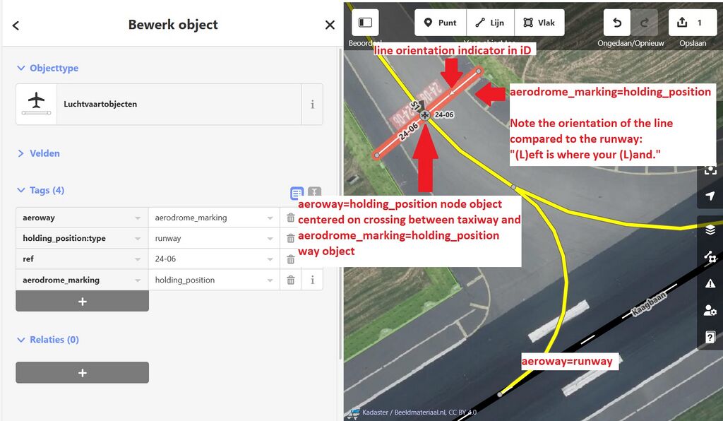
Example of correctly oriented and digitized aeroway=holding_position_line way object, that takes into account the position of the associated runway.
Licensing
ISC
Screenshot of iD editor. It may contain different content with different licensing.
The iD editor software is published under ISC License – Copyright iD Contributors.
The iD editor software is published under ISC License – Copyright iD Contributors.
Permission to use, copy, modify, and/or distribute this software for any purpose with or without fee is hereby granted, provided that the above copyright notice and this permission notice appear in all copies.
THE SOFTWARE IS PROVIDED "AS IS" AND THE AUTHOR DISCLAIMS ALL WARRANTIES WITH REGARD TO THIS SOFTWARE INCLUDING ALL IMPLIED WARRANTIES OF MERCHANTABILITY AND FITNESS. IN NO EVENT SHALL THE AUTHOR BE LIABLE FOR ANY SPECIAL, DIRECT, INDIRECT, OR CONSEQUENTIAL DAMAGES OR ANY DAMAGES WHATSOEVER RESULTING FROM LOSS OF USE, DATA OR PROFITS, WHETHER IN AN ACTION OF CONTRACT, NEGLIGENCE OR OTHER TORTIOUS ACTION, ARISING OUT OF OR IN CONNECTION WITH THE USE OR PERFORMANCE OF THIS SOFTWARE.Imagery in the background: Beeldmateriaal.nl
![]()
![]()
This work is licensed under the Creative Commons Attribution 4.0 License.
Attribution: Beeldmateriaal.nl
Attribution: Beeldmateriaal.nl
File history
Click on a date/time to view the file as it appeared at that time.
| Date/Time | Thumbnail | Dimensions | User | Comment | |
|---|---|---|---|---|---|
| current | 20:36, 5 January 2024 | | 1,611 × 938 (302 KB) | Mboeringa (talk | contribs) | Updated image to adapt to changes in the tagging proposal based on discussion |
| 13:59, 31 August 2022 |  | 1,683 × 827 (249 KB) | Mboeringa (talk | contribs) |
You cannot overwrite this file.
File usage
The following page uses this file: