File:Autonomous areas.svg
Jump to navigation
Jump to search


Size of this PNG preview of this SVG file: 800 × 353 pixels. Other resolutions: 320 × 141 pixels | 640 × 283 pixels | 1,024 × 452 pixels | 1,280 × 565 pixels | 940 × 415 pixels.
Original file (SVG file, nominally 940 × 415 pixels, file size: 1.79 MB)
This file and its description are from Wikimedia Commons.
Summary
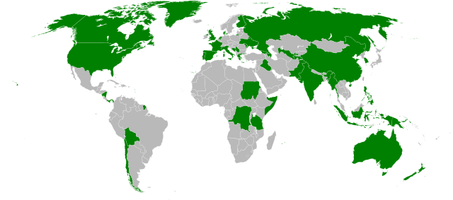
| Description |
English: Countries with at least one autonomous area, as of 2009 |
||
| Date | |||
| Source | Own work | ||
| Author | Turkish Flame | ||
| Permission (Reusing this file) |
|

Licensing
| This file is made available under the Creative Commons CC0 1.0 Universal Public Domain Dedication. | |
| The person who associated a work with this deed has dedicated the work to the public domain by waiving all of their rights to the work worldwide under copyright law, including all related and neighboring rights, to the extent allowed by law. You can copy, modify, distribute and perform the work, even for commercial purposes, all without asking permission.
|
File history
Click on a date/time to view the file as it appeared at that time.
| Date/Time | Thumbnail | Dimensions | User | Comment | |
|---|---|---|---|---|---|
| current | 13:22, 21 September 2022 | | 940 × 415 (1.79 MB) | wikimediacommons>Salma3232 | Reverted to version as of 12:50, 29 October 2020 (UTC) |
File usage
There are no pages that use this file.