File:Autorizacao IPECE.pdf
 Size of this JPG preview of this PDF file: 800 × 566 pixels. Other resolutions: 320 × 226 pixels | 640 × 453 pixels | 1,024 × 724 pixels | 1,280 × 905 pixels | 1,752 × 1,239 pixels. |

Original file (1,752 × 1,239 pixels, file size: 150 KB, MIME type: application/pdf, 3 pages)
Summary
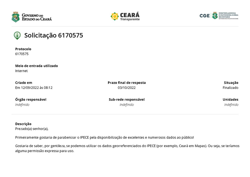
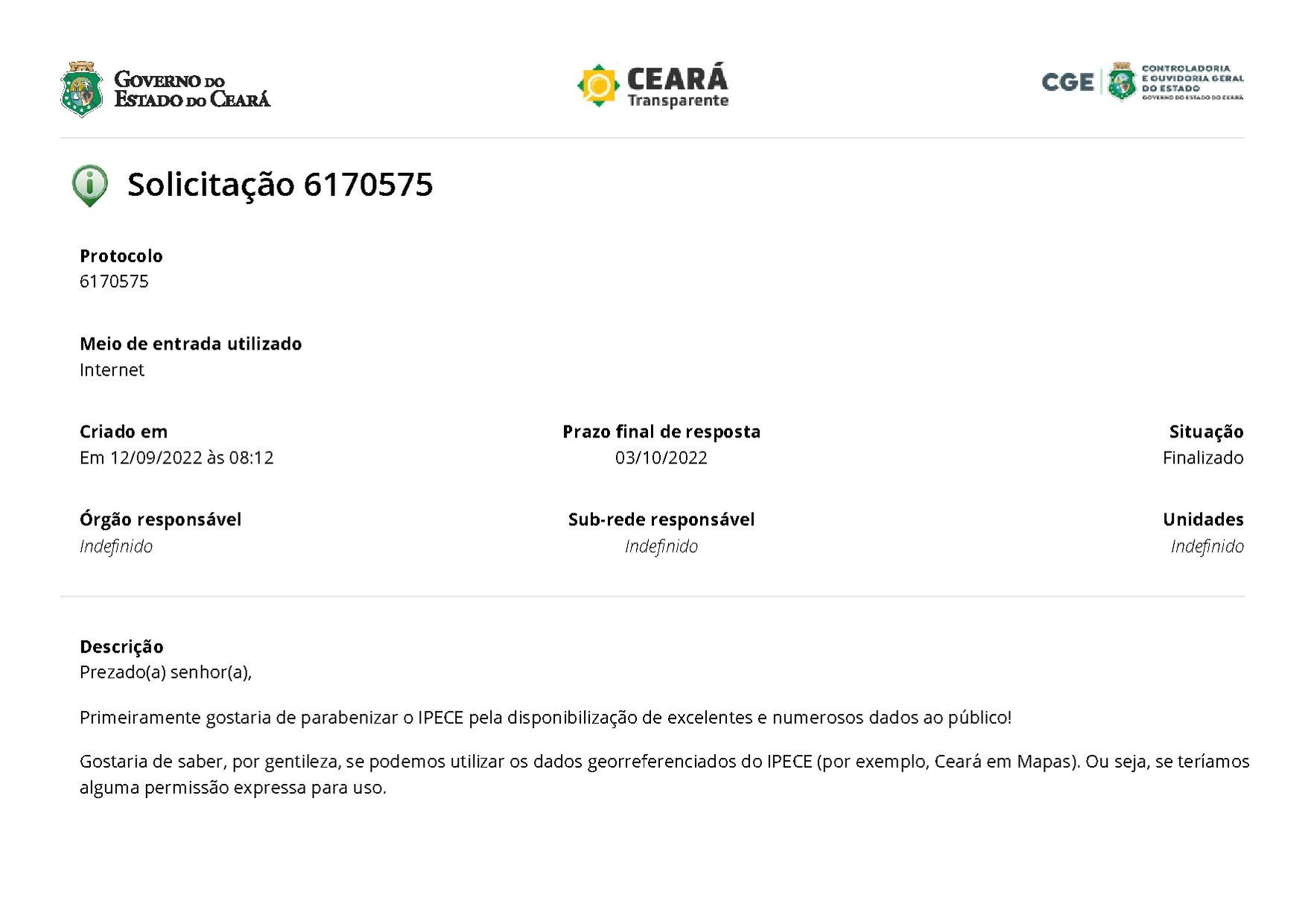
| Description | Capture of the e-mail sent by IPECE (Institute of Research and Economic Strategy of Ceará), where the use of their data is authorized on OpenStreetMap. |
|---|---|
| Author | matheusgomesms |
| Source | Own |
| Date | 2022-09-12 |
English
Message Transcript and translated:
Dear Sir,
First of all, I would like to congratulate IPECE for making excellent and numerous data available to the public!
I would like to know, please, if we can use the georeferenced data from IPECE (for example, Ceará in Maps). That is, if we would have any express permission for use.
We intend (the community as a whole) to use the extremely useful information from this data in the OpenStreetMap (OSM) project, which aims to develop a free geographic information base where ordinary people can contribute to map making if they make creative use of it. of these data. The entire OSM project is non-profit.
The OSM Ceará community is strengthening ties with various public agencies, and we have always had a great reception. We even have permission and use data from the City Halls of Fortaleza and Sobral, in addition to various agencies in Brazil and the world, for example.
So, could we use the IPECE data? We always mention the data sources, and all data used in OSM is completely free. A simple confirmation via email is enough.
Thank you in advance for your attention and I remain at your disposal for any clarifications.
Yours sincerely,
Matheus Gomes
IPECE Response
Dear Mr. Matheus Gomes, good morning.
Greeting you cordially, we refer to your request for protocol n° 6170575 via SIC of the Institute of Research and Economic Strategy of Ceará - IPECE.
IPECE's mission is to generate and disseminate knowledge and information and, through the Ceará in Maps interactive portal, georeferenced information, as well as its metadata, are made available to the whole society. Therefore, there is no objection to the use of the georeferenced base in the OSM platform.
We emphasize the importance of mentioning the source of the data.
Yours sincerely,
SIC / IPECE
Português
Captura da mensagem de e-mail emitido pelo IPECE (Instituto de Pesquisa e Estratégia Econômica do Ceará), onde se autoriza o uso dos seus dados no OpenStreetMap.
Transcrição da mensagem:
Prezado(a) senhor(a),
Primeiramente gostaria de parabenizar o IPECE pela disponibilização de excelentes e numerosos dados ao público!
Gostaria de saber, por gentileza, se podemos utilizar os dados georreferenciados do IPECE (por exemplo, Ceará em Mapas). Ou seja, se teríamos alguma permissão expressa para uso.
Pretendemos (a comunidade como um todo) usar as informações extremamente úteis desses dados no projeto OpenStreetMap (OSM), que tem como objetivo desenvolver uma base de informações geográficas livres, onde as pessoas comuns podem contribuir com a elaboração de mapa se fazer um uso criativo destes dados. Todo o projeto OSM não tem fins lucrativos.
A comunidade OSM Ceará está fortalecendo os laços com vários órgãos públicos, e sempre tivemos uma ótima recepção. Inclusive temos permissão e utilizamos os dados das Prefeituras de Fortaleza e de Sobral, além de vários órgãos no Brasil e mundo, por exemplo.
Sendo assim, poderíamos utilizar os dados do IPECE? Sempre mencionamos as fontes dos dados, e todos os dados utilizados no OSM são totalmente livres. Uma simples confirmação via e-mail já é suficiente.
Desde já agradeço vossa atenção e me ponho à disposição para eventuais esclarecimentos.
Atenciosamente,
Matheus Gomes
Resposta IPECE
Prezado sr. Matheus Gomes, bom dia.
Cumprimentando-o cordialmente, fazemos referência a sua demanda de protocolo n° 6170575 via SIC do Instituto de Pesquisa e Estratégia Econômica do Ceará - IPECE.
O IPECE tem como missão gerar e disseminar conhecimento e informação e, por meio do sistema Ceará em Mapas interativos, as informações georreferenciadas, bem como seus metadados, são disponibilizadas para toda a sociedade. Sendo assim, não há objeção no uso da base georreferenciada na plataforma OSM.
Destacamos a importância de mencionar a fonte dos dados.
Atenciosamente,
SIC/IPECE
Licensing
- This media file was uploaded by author of the work and its copyright holder.
![]()
![]()
The person who associated a work with this deed has dedicated the work to the public domain by waiving all of his or her rights to the work worldwide under copyright law, including all related and neighboring rights, to the extent allowed by law. You can copy, modify, distribute and perform the work, even for commercial purposes, all without asking permission.
File history
Click on a date/time to view the file as it appeared at that time.
| Date/Time | Thumbnail | Dimensions | User | Comment | |
|---|---|---|---|---|---|
| current | 15:12, 23 September 2022 |  | 1,752 × 1,239, 3 pages (150 KB) | Matheusgomesms (talk | contribs) | {{Information | description= | source= | date= | author= | permission= | other_versions= }} |
You cannot overwrite this file.
File usage
There are no pages that use this file.