File:AutorizacionINECensoUy.pdf

Original file (1,239 × 1,752 pixels, file size: 16 KB, MIME type: application/pdf)
Summary
| Description | Capture of the e-mail sent by INE-Uruguay (Uruguayan Institute of Statistics), where the use of their data is authorized on OpenStreetMap. |
|---|---|
| Author | Cbarretouy |
| Source | Own |
| Date | 2023-02-07 |
English
Message Transcript and translated:
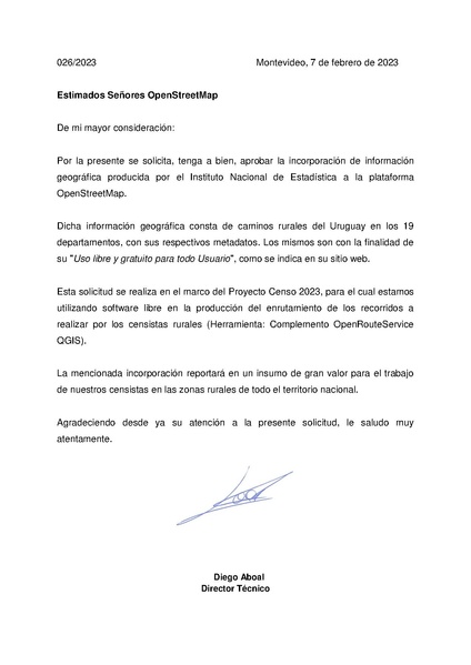
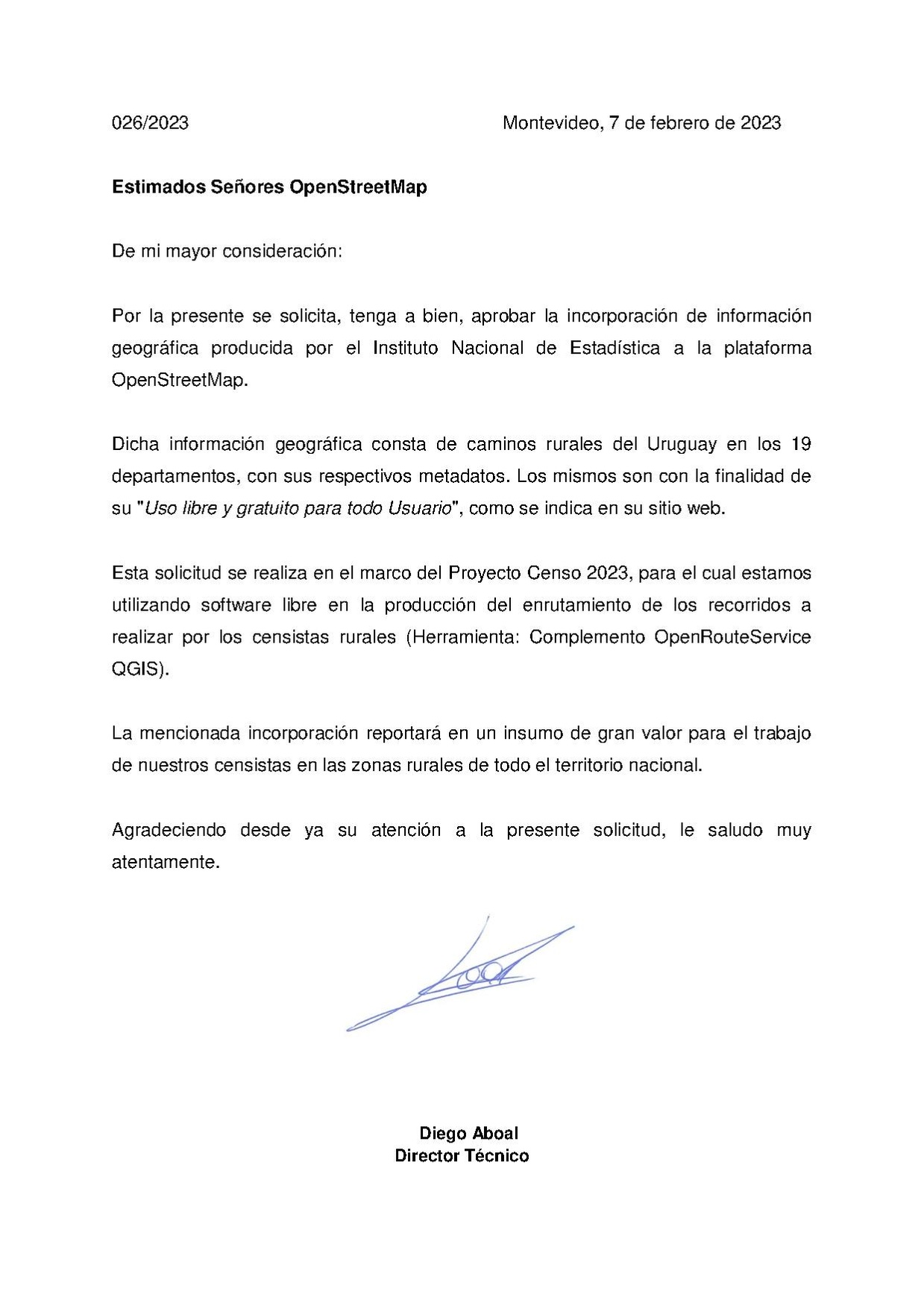
026/2023 Montevideo, February 7, 2023
Dear OpenStreetMap Gentlemen
From my greatest consideration:
It is hereby requested, kindly, to approve the incorporation of geographic information produced by the Instituto Nacional de Estadística to the OpenStreetMap platform.
This geographic information consists of rural roads of Uruguay in the 19 departments, with their respective metadata. The same ones are for the purpose of its "Open and free use for all Users", as indicated on its website.
This request is carried out within the framework of the 2023 Census Project, for which we are using free software in the production of the route routing to be carried out by rural census takers (Tool: Plugin OpenRouteService QGIS).
The aforementioned incorporation will report on an input of great value for the work of our census takers in rural areas throughout the national territory.
Thanking you in advance for your attention to this request, I salute you very carefully.
Diego Aboal
Technical director
Español
Captura del mensaje de correo electrónico emitido por el INE-Uruguay, donde se autoriza el uso de sus datos en OpenStreetMap.
Transcripción del mensaje:
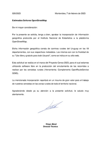
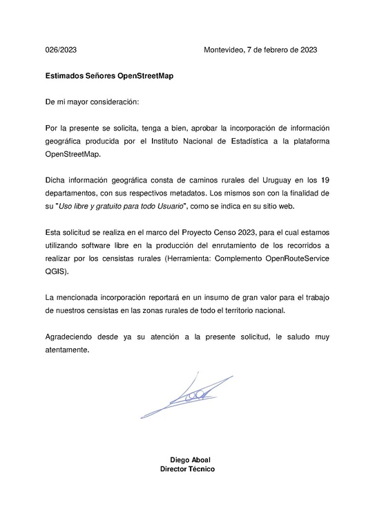
026/2023 Montevideo, 7 de febrero de 2023
Estimados Señores OpenStreetMap
De mi mayor consideración:
Por la presente se solicita, tenga a bien, aprobar la incorporación de información geográfica producida por el Instituto Nacional de Estadística a la plataforma OpenStreetMap.
Dicha información geográfica consta de caminos rurales del Uruguay en los 19 departamentos, con sus respectivos metadatos. Los mismos son con la finalidad de su "Uso libre y gratuito para todo Usuario", como se indica en su sitio web.
Esta solicitud se realiza en el marco del Proyecto Censo 2023, para el cual estamos utilizando software libre en la producción del enrutamiento de los recorridos a realizar por los censistas rurales (Herramienta: Complemento OpenRouteService QGIS).
La mencionada incorporación reportará en un insumo de gran valor para el trabajo de nuestros censistas en las zonas rurales de todo el territorio nacional.
Agradeciendo desde ya su atención a la presente solicitud, le saludo muy atentamente.
Diego Aboal
Director Técnico
Licensing
![]()
![]()
The person who associated a work with this deed has dedicated the work to the public domain by waiving all of his or her rights to the work worldwide under copyright law, including all related and neighboring rights, to the extent allowed by law. You can copy, modify, distribute and perform the work, even for commercial purposes, all without asking permission.
File history
Click on a date/time to view the file as it appeared at that time.
| Date/Time | Thumbnail | Dimensions | User | Comment | |
|---|---|---|---|---|---|
| current | 22:46, 19 February 2023 |  | 1,239 × 1,752 (16 KB) | Matheusgomesms (talk | contribs) | {{Information | description= | source= | date= | author= | other_versions= }} |
You cannot overwrite this file.
File usage
There are no pages that use this file.