File:Autorizacion fotos fachadas catastro.pdf

Original file (1,239 × 1,752 pixels, file size: 45 KB, MIME type: application/pdf)
Summary
English
Snapshot of the email send by the Spanish General Directorate for Cadastre giving permission to use the front photograps to add house numbers to the OpenStreetMap plataform.
Translation of the message:
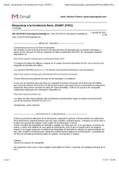
Answer to incident #: 253087 (PRO)
1 message
SIN_RESPUESTA@catastro.minhafp.es <SIN_RESPUESTA@catastro.minhafp.es>
7 july 2017, 11:08
To: JAVIERSANP@gmail.com
--------------------------------------ORIGINAL MESSAGE--------------------------------------
Asking for facade photographs license of use.
I'm asking about the license of use for the facade photographs available to download throught the INSPIRE ATOM Services of Cadastral Cartography data sets available in:http://www.catastro.minhap.gob.es/webinspire/index.html
The buildings data set contains in the 'bu-ext2d:document' field a URL which links to a front image of the building.
The INSPIRE services of the G.D.C. are offered with the license described in this document:
http://www.catastro.minhap.gob.es/webinspire/documentos/Licencia.pdf
This license is valid also for the facade photographs or they have another?
We would like to use this photographs to check the house number with the address of the building provided by the Addresses ATOM Service as a previous step for a possible manual incorporation of addresses to the OpenStreetMap data base. OSM is a collaborative cartography project make by volunteers, available in:The addresses data will be previously transformed as stated by your license of use.
Greetings, Javier Sanchez
--------------------------------- ANSWER TO THE INCIDENCE --------------------------------
the license allows to use the cadastral information in general. It allows also to reuse the cadastral information when there are an added value and transformation. Always you must attribute to the general directorate of cadastre as source of the information. You can consult the phacade photograps and work with them to see, if available, the police number, and add this attribute to your data layers, but what can not do of any way and in no case is it to publish the facade photographs of cadastre in openstreetmap. There are not added value to the cadastral information or any transformation of the information. The publication of the georreferenced phacade photographs corresponds only to cadastreGreetings,
Service of support to cartography.
Spanish
Captura del mensaje de correo electrónico remitido por la Dirección General del Catastro Español donde se autoriza el uso de las fotos de fachadas para agregar datos de portales a la plataforma OpenStreetMap.
Transcripción íntegra del mensaje:
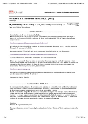
Respuesta a la incidencia Num: 253087 (PRO)
1 mensaje
SIN_RESPUESTA@catastro.minhafp.es <SIN_RESPUESTA@catastro.minhafp.es>
7 de julio de 2017, 11:08
Para: JAVIERSANP@gmail.com
--------------------------------------MENSAJE ORIGINAL--------------------------------------
Consulta licencia de uso de fotos de fachadas.
Mi consulta es acerca de la licencia de uso para las fotos de fachadas que se pueden descargar a través de los Servicios ATOM de conjuntos de datos predefinidos INSPIRE de Cartografía Catastral disponibles en:http://www.catastro.minhap.gob.es/webinspire/index.html
El conjunto de datos de edificios contiene en el campo 'bu-ext2d:document' la URL con el acceso a la fotografía de fachada del edificio.
Los servicios INSPIRE de la D.G.C. se ofrecen con la licencia descrita en este documento:
http://www.catastro.minhap.gob.es/webinspire/documentos/Licencia.pdf
¿Cubre dicha licencia también las fotos de las fachadas o es distinta?
El uso que se pretende dar a las fotos es contrastar el numero de portal con la dirección del edificio que se puede obtener del Servicio ATOM de direcciones como paso previo a una posible incorporación manual de direcciones a la base de datos de OpenStreetMap. OSM es un proyecto de cartografía colaborativa elaborado por voluntarios, disponible en:Los datos de direcciones habrían sido previamente transformados según se indica en la licencia de uso de los servicios INSPIRE de la D.G.C.
Atentamente, Javier Sánchez
--------------------------------- RESPUESTA A LA INCIDENCIA --------------------------------
la licencia permite la utilización de la información catastral en general. Permite también la reutilización de la información catastral siempre que hay valor añadido y transformación. Y siempre se ha de citar a la dirección general del catastro como origen de la información o fuente Puede consultar las fotografías de fachada y trabajar con ellas para ver, si es que figura, el número de policía, y poner este atributo en sus capas de información, pero lo que no puede hacer de ninguna manera y en ningún supuesto es publicar las fotografías de fachada de catastro en openstreetmap. No hay valor añadido a la información catastral ni transformación alguna de la información. La publicación de fotos de fachada georreferenciadas de catastro corresponde a catastroSaludos,
Servicio de soporte de cartografía.
File history
Click on a date/time to view the file as it appeared at that time.
| Date/Time | Thumbnail | Dimensions | User | Comment | |
|---|---|---|---|---|---|
| current | 14:50, 7 July 2017 |  | 1,239 × 1,752 (45 KB) | Javiersanp (talk | contribs) | Consulta sobre uso de las fotos de fachadas de la Dirección General de Catastro en ES:Catastro_español/Importación de edificios. |
You cannot overwrite this file.
File usage
There are no pages that use this file.