File:Before and after leeds mapping party.jpg
Jump to navigation
Jump to search

Size of this preview: 640 × 599 pixels. Other resolutions: 256 × 240 pixels | 642 × 601 pixels.
Original file (642 × 601 pixels, file size: 121 KB, MIME type: image/jpeg)
Summary
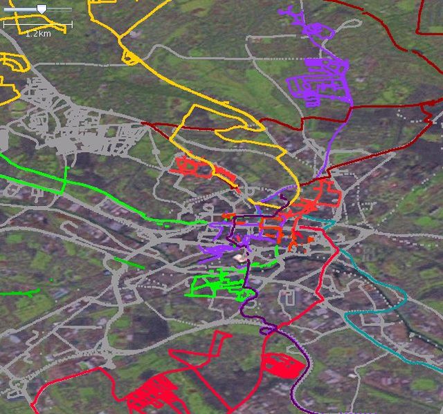
| Description | before and after Leeds mapping party 2007 traces. I made this image using GPS traces, JOSM and landsat imagery. the coloured GPS traces were collected by participants at the mapping party. The grey traces are from the OSM API. |
|---|---|
| Author | Chippy |
| Source | own work |
| Date | 2007-09-18 |
Licensing
![]()
This file is a screenshot of the software JOSM, with imagery in background. It may include old OpenStreetMap data (before September 12, 2012), in such case CC-BY-SA-2.0 also applies.
Imagery in background: Landsat Imagery
![]()
"JOSM" (Java OpenStreetMap Editor – josm.openstreetmap.de) is free software released under the terms of the GNU General Public License as published by the Free Software Foundation; either version 2 of the license, or any later version.
![]()
Contains map data © OpenStreetMap contributors, made available under the terms of the Creative Commons Attribution-ShareAlike 2.0 (CC-BY-SA-2.0).
File history
Click on a date/time to view the file as it appeared at that time.
| Date/Time | Thumbnail | Dimensions | User | Comment | |
|---|---|---|---|---|---|
| current | 15:50, 18 September 2007 | | 642 × 601 (121 KB) | Chippy (talk | contribs) | before and after leeds mapping part 2007 traces |
You cannot overwrite this file.
File usage
The following page uses this file: