File:BingAreaMap Atlantico.png
Jump to navigation
Jump to search


Size of this preview: 542 × 599 pixels. Other resolutions: 217 × 240 pixels | 434 × 480 pixels | 666 × 736 pixels.
Original file (666 × 736 pixels, file size: 856 KB, MIME type: image/png)
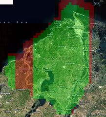
Screenshot of Bing Analyzer II using permalink http://ant.dev.openstreetmap.org/bingimageanalyzer/?lat=10.699059549939122&lon=-74.9646653439298&zoom=10 . Used to illustrate example coverage result, focusing on the Atlantico Department in Colombia.
License status - unknown. contributed by Ceyockey
File history
Click on a date/time to view the file as it appeared at that time.
| Date/Time | Thumbnail | Dimensions | User | Comment | |
|---|---|---|---|---|---|
| current | 12:26, 8 February 2011 | | 666 × 736 (856 KB) | Ceyockey (talk | contribs) | Screenshot of Bing Analyzer II using permalink http://ant.dev.openstreetmap.org/bingimageanalyzer/?lat=10.699059549939122&lon=-74.9646653439298&zoom=10 . Used to illustrate example coverage result, focusing on the Atlantico Department in Colombia. Licen |
You cannot overwrite this file.
File usage
The following page uses this file: