File:Br-classificacao-aracaju-se-plano-diretor.jpg
Jump to navigation
Jump to search

Size of this preview: 322 × 600 pixels. Other resolutions: 129 × 240 pixels | 257 × 480 pixels | 412 × 768 pixels | 1,024 × 1,908 pixels.
Original file (1,024 × 1,908 pixels, file size: 491 KB, MIME type: image/jpeg)
Summary
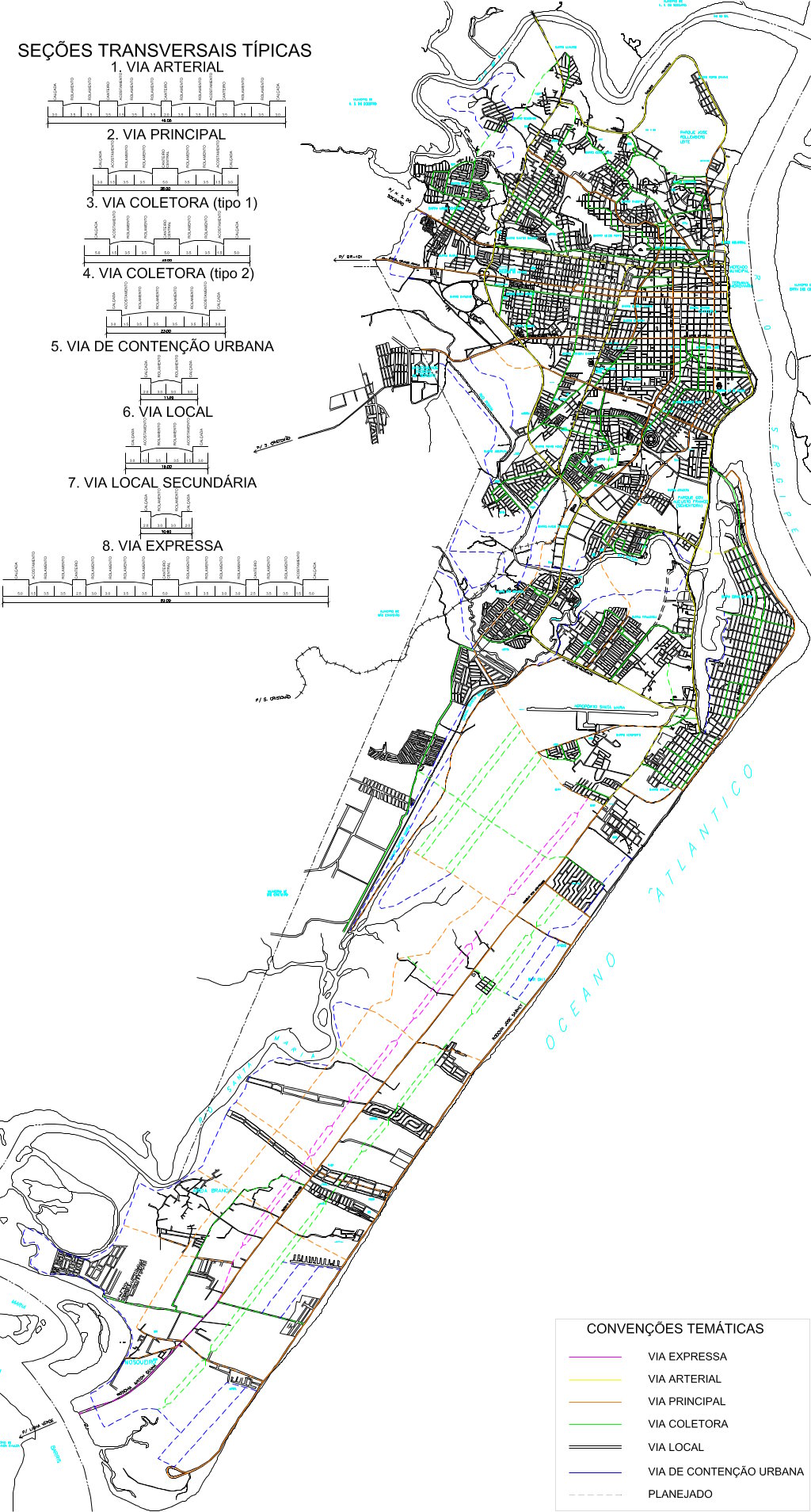
Classificação oficial segundo o plano diretor, publicada em 4 de março de 2011.
Disponível oficialmente no site da Prefeitura, neste link direto (talvez citado em algum lugar dentro de Administração Indireta > Obras e Urbanização - EMURB) > Anexo VI C: áreas de desenvolvimento econômico. Para ter mais qualidade, a imagem (com informação idêntica à original) foi obtida desta fonte.
Licensing
![]()
This file has been released into the public domain by the copyright holder, its copyright has expired, or it is ineligible for copyright. This applies worldwide.
Please, please use more specific template such as {{PD-self}} / {{PD-creator}} / {{PD-shape}} / {{PD-USGov}} / {{PD-old}} / {{PD-RU-exempt}} ... This template is not making clear why this work is in the public domain.
Please, please use more specific template such as {{PD-self}} / {{PD-creator}} / {{PD-shape}} / {{PD-USGov}} / {{PD-old}} / {{PD-RU-exempt}} ... This template is not making clear why this work is in the public domain.
File history
Click on a date/time to view the file as it appeared at that time.
| Date/Time | Thumbnail | Dimensions | User | Comment | |
|---|---|---|---|---|---|
| current | 15:48, 3 October 2015 | | 1,024 × 1,908 (491 KB) | Ftrebien (talk | contribs) | Classificação oficial segundo o plano diretor, publicada em 4 de março de 2011. Disponível oficialmente no site da [http://aracaju.se.gov.br/ Prefeitura], [http://www.aracaju.se.gov.br/userfiles/seplan/arquivos/Plano_Diretor/Plandir_aprovado.pdf... |
You cannot overwrite this file.
File usage
The following page uses this file: