File:Brixton-sketchy-lines.png
Jump to navigation
Jump to search


Size of this preview: 800 × 509 pixels. Other resolutions: 320 × 204 pixels | 640 × 407 pixels | 1,024 × 652 pixels | 1,391 × 885 pixels.
Original file (1,391 × 885 pixels, file size: 435 KB, MIME type: image/png)
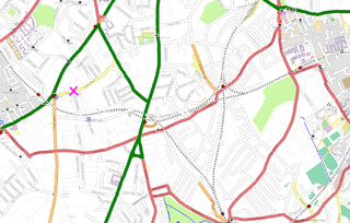
Brixton (map) done in preparation for London/Summer 2008 Mapping Party Marathon/2008-05-28 using an early incarnation of SketchyKosmosRules. Note that this isn't showing unnamed highway=unclassified roads correctly.
Also showing pub location at the pink cross
File history
Click on a date/time to view the file as it appeared at that time.
| Date/Time | Thumbnail | Dimensions | User | Comment | |
|---|---|---|---|---|---|
| current | 23:12, 27 May 2008 | | 1,391 × 885 (435 KB) | Harry Wood (talk | contribs) | Brixton ([http://www.openstreetmap.org/?lat=51.46275&lon=-0.11452&zoom=15&layers=B00FF map]) done in the sketchy lines style using Kosmos |
You cannot overwrite this file.
File usage
The following page uses this file: