File:Buildingmapping-r1s1.png
Buildingmapping-r1s1.png (320 × 400 pixels, file size: 83 KB, MIME type: image/png)
Summary
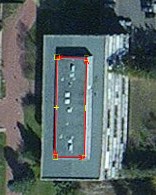
Stepwise illustration of mapping buildings, round 1 step 1. (See Buildings article for details).
Image composition: Cropped screenshot of a JOSM editing session with the ESRI Clarity background layer (technically Bing material from around 2010).
Licensing
![]()
![]()
![]()
Esri (ArcGIS.com): "(...) Esri and its imagery contributors grant Users the non-exclusive right to use the World Imagery map to trace features and validate edits in the creation of vector data. Users that create vector data from the World Imagery map may want to publicly share that vector data through a GIS data clearinghouse of its own or through another open data site. This public sharing could be achieved through ArcGIS Open Data or the OpenStreetMap (OSM) Initiative. For ArcGIS users that want to contribute such vector data to OSM, Esri provides applications and services directly accessible from ArcGIS platform. Users acknowledge that any vector data contributed to OSM is then governed by and released under the OpenStreetMap License (e.g. ODbL).
Except for the additional limited rights granted above, any and all other uses of the World Imagery map remain subject to the terms and conditions set forth in the Esri Master Agreement or Terms of Use, as applicable. Esri and its imagery contributors retain all right, title, and interest in and to their respective imagery data contributed to the World Imagery map." (→ source)
"For More Info, visit: https://goto.arcgisonline.com/maps/World_Imagery "
| Contains map data © OpenStreetMap contributors, made available under the terms of the Open Database License (ODbL).
The ODbL does not require any particular license for maps produced from ODbL data, produced maps may be subject also to other licences. |
File history
Click on a date/time to view the file as it appeared at that time.
| Date/Time | Thumbnail | Dimensions | User | Comment | |
|---|---|---|---|---|---|
| current | 14:48, 12 June 2020 | | 320 × 400 (83 KB) | Jengelh (talk | contribs) | Stepwise illustration of mapping buildings, round 1 step 1. (See Buildings article for details). Image composition: Cropped screenshot of a JOSM editing session with the ESRI Clarity background layer (technically Bing material from around 2010). |
You cannot overwrite this file.
File usage
The following page uses this file: