File:Buildings and addresses.png
Jump to navigation
Jump to search


Size of this preview: 800 × 214 pixels. Other resolutions: 320 × 86 pixels | 1,165 × 312 pixels.
Original file (1,165 × 312 pixels, file size: 318 KB, MIME type: image/png)
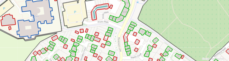
An overlay from ITO Map showing buildings in blue if they are named, in green if they have a number of in red if they have neither. Address ranges (of which there is only one in this view) is shown in turquoise.
![]()
Contains map data © OpenStreetMap contributors, made available under the terms of the Creative Commons Attribution-ShareAlike 2.0 (CC-BY-SA-2.0).
File history
Click on a date/time to view the file as it appeared at that time.
| Date/Time | Thumbnail | Dimensions | User | Comment | |
|---|---|---|---|---|---|
| current | 20:43, 3 March 2011 | 1,165 × 312 (318 KB) | PeterIto (talk | contribs) | An overlay from ITO Map showing buildings in blue if they are named, in green if they have a number of in red if they have neither. Address ranges (of which there is only one in this view) is shown in turquoise. |
You cannot overwrite this file.
File usage
The following 4 pages use this file: