File:ConnectivityExample7.png
Jump to navigation
Jump to search

No higher resolution available.
ConnectivityExample7.png (744 × 500 pixels, file size: 692 KB, MIME type: image/png)
Summary
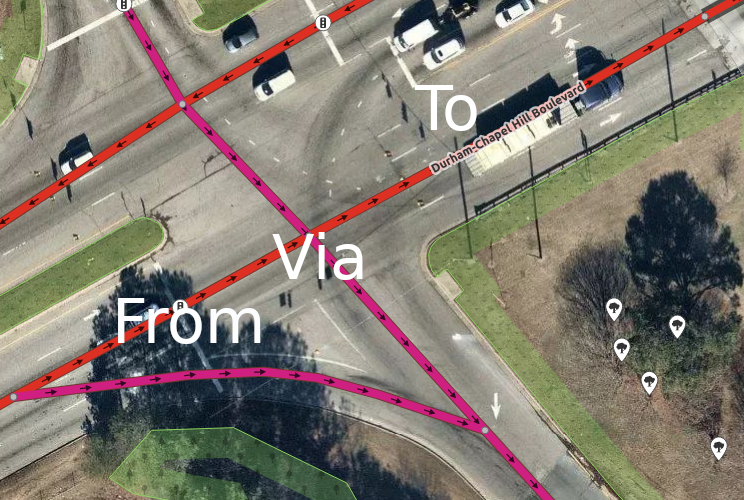
An example of where a connectivity relation could make existing lane assist (turn:lanes) more accurate. The left lane of the from way becomes a left turn lane in to, so lane assist from navigation apps shouldn't suggest using that lane if the driver isn't going to turn left at the next intersection. Mapbox Imagery of this location: https://www.osm.org/#map=19/35.95010/-79.00061
![]()
This image is composed partially or entirely of imagery from Mapbox.
The Mapbox imagery is not open licensed, but is made available to the OpenStreetMap project for deriving open licensed map data (see Mapbox page for details). This image is used for illustrative purposes on the OpenStreetMap wiki, to help document ways of using and interpreting the imagery in the OpenStreetMap mapping process and is used here with Mapbox's express permission for that purpose.
The Mapbox imagery is not open licensed, but is made available to the OpenStreetMap project for deriving open licensed map data (see Mapbox page for details). This image is used for illustrative purposes on the OpenStreetMap wiki, to help document ways of using and interpreting the imagery in the OpenStreetMap mapping process and is used here with Mapbox's express permission for that purpose.
File history
Click on a date/time to view the file as it appeared at that time.
| Date/Time | Thumbnail | Dimensions | User | Comment | |
|---|---|---|---|---|---|
| current | 12:40, 10 June 2019 | | 744 × 500 (692 KB) | LeifRasmussen (talk | contribs) | An example of where a connectivity relation could make existing lane assist (turn:lanes) more accurate. The left lane of the ''from'' way becomes a left turn lane in ''to'', so lane assist from navigation apps shouldn't suggest using that lane if the... |
You cannot overwrite this file.
File usage
The following 3 pages use this file: