File:Cycle map with contours bern.png
Jump to navigation
Jump to search


Size of this preview: 800 × 600 pixels. Other resolutions: 320 × 240 pixels | 640 × 480 pixels | 824 × 618 pixels.
Original file (824 × 618 pixels, file size: 755 KB, MIME type: image/png)
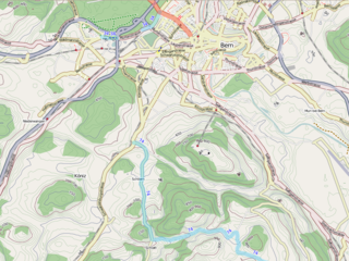
The OSM Cycle Map with contours, showing an area around Bern, Switzerland.
An explanation of the process for creating these contours is available at Contours on the Cycle Map
This is a Featured image, which means that it has been identified as one of the best examples of OpenStreetMap mapping, or that it provides a useful illustration of the OpenStreetMap project. If you know another image of similar quality, you can nominate it on Featured image proposals.
Front-page image on 01 Mar 2008
File history
Click on a date/time to view the file as it appeared at that time.
| Date/Time | Thumbnail | Dimensions | User | Comment | |
|---|---|---|---|---|---|
| current | 00:08, 1 March 2008 | | 824 × 618 (755 KB) | Colin Marquardt (talk | contribs) | The Cycle Map with contours, showing an area around Bern, Switzerland. |
You cannot overwrite this file.
File usage
The following 2 pages use this file: