File:Warma Zambia Mapathon 2019.jpg
(Redirected from File:D6dAQG4WwAA4Ewk.jpg-large.jpeg)
Jump to navigation
Jump to search

Size of this preview: 800 × 450 pixels. Other resolutions: 320 × 180 pixels | 640 × 360 pixels | 1,024 × 576 pixels.
Original file (1,024 × 576 pixels, file size: 150 KB, MIME type: image/jpeg)
Summary
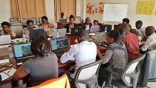
Hans van der Kwast organised a mapathon at Warma Zambia, helping them learn OpenStreetMap while mapping Zambia for disaster preparedness and water/sanitation provision (HOT Task)
Original tweet https://twitter.com/hansakwast/status/1127940889647697920 and photo by Hans van der Kwast
Licensing
![]()
![]()
![]()
This work is licensed under the Creative Commons Attribution-ShareAlike 4.0 License.
Attribution not specified as a parameter! THIS LICENSE ALWAYS REQUIRES ATTRIBUTION! Use {{CC-BY-SA-4.0|Attribution, typically name of author}} See Template:CC-BY-SA-4.0 for full description this template should be used.
Attribution not specified as a parameter! THIS LICENSE ALWAYS REQUIRES ATTRIBUTION! Use {{CC-BY-SA-4.0|Attribution, typically name of author}} See Template:CC-BY-SA-4.0 for full description this template should be used.
File history
Click on a date/time to view the file as it appeared at that time.
| Date/Time | Thumbnail | Dimensions | User | Comment | |
|---|---|---|---|---|---|
| current | 15:59, 14 May 2019 | | 1,024 × 576 (150 KB) | Harry Wood (talk | contribs) | Hans van der Kwast [https://twitter.com/hansakwast/status/1127940889647697920 organised] a mapathon at [http://www.warma.org.zm Warma] Zambia, helping them learn OpenStreetMap while mapping Zambia for disaster preparedness and water/sanitation provisio... |
You cannot overwrite this file.
File usage
The following 6 pages use this file: