File:Densité arbre commune.png
Original file (809 × 631 pixels, file size: 114 KB, MIME type: image/png)
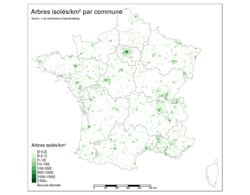
Densité d'arbres isolés par commune par km2, basé sur OSM 04/2019
I created this file with this R script (https://github.com/defuneste/arbresosm/blob/85fece7577f46d13889be13d44210d469ec9f1a4/representation_administrative.R#L143-L232).
As a author I want it to be
- This media file was uploaded by author of the work and its copyright holder.
![]()
![]()
The person who associated a work with this deed has dedicated the work to the public domain by waiving all of his or her rights to the work worldwide under copyright law, including all related and neighboring rights, to the extent allowed by law. You can copy, modify, distribute and perform the work, even for commercial purposes, all without asking permission.
.
| Contains map data © OpenStreetMap contributors, made available under the terms of the Open Database License (ODbL).
The ODbL does not require any particular license for maps produced from ODbL data, produced maps may be subject also to other licences. |
File history
Click on a date/time to view the file as it appeared at that time.
| Date/Time | Thumbnail | Dimensions | User | Comment | |
|---|---|---|---|---|---|
| current | 14:50, 25 April 2019 | | 809 × 631 (114 KB) | Defuneste (talk | contribs) |
You cannot overwrite this file.
File usage
The following page uses this file: