File:Disneyland.png
Jump to navigation
Jump to search


No higher resolution available.
Disneyland.png (565 × 559 pixels, file size: 401 KB, MIME type: image/png)
Summary
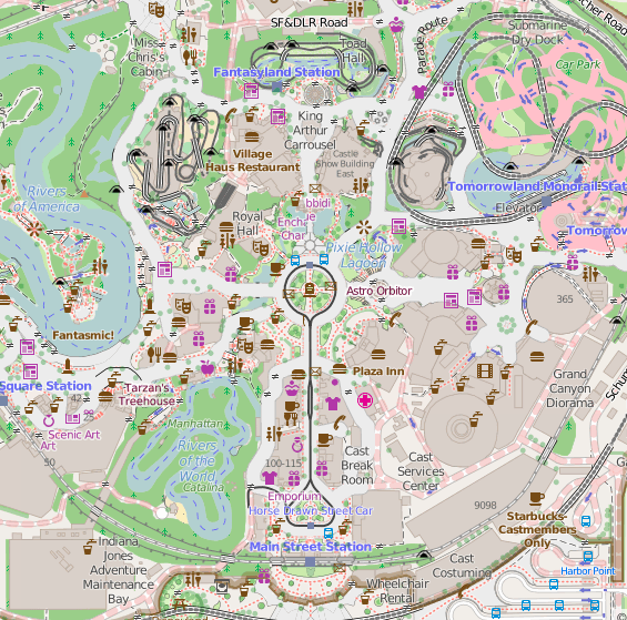
Map of Disneyland as of end of June 2015. Standard tile layer
This is a Featured image, which means that it has been identified as one of the best examples of OpenStreetMap mapping, or that it provides a useful illustration of the OpenStreetMap project. If you know another image of similar quality, you can nominate it on Featured image proposals.
Front-page image for week 29 of 2015 (13–19 Jul.).
- Image descriptions
- English : Disneyland in California is celebrating its 60th anniversary this week. Kiosks, gardens and the routes of the roller-coasters, have all been mapped in glorious detail here on OpenStreetMap
- français : Cette semaine le célèbre parc californien Disneyland fête son 60 ème anniversaire. Kiosques, jardins, rails de montagne russe, tout a été mapper dans les moindres détails
- italiano : Disneyland in California celebra questa settimana il suo 60° anniversario. Tutti i chioschi, giardini e i percorsi delle montagne russe sono stati mappati con notevole dettaglio, guarda su OpenStreetMap
- polski : Kalifornijski Disneyland obchodzi w tym tygodniu swoje 60. urodziny. Wszystkie budki, ogrody i tory kolejek górskich zostały szczegółowo odwzorowane na OpenStreetMap
- русский : На этой неделе калифорнийский Диснейленд празднует своё шестидесятилетие. Магазинчики, сады, американские горки, дорожки — всё это отмечено на карте ОСМ в мельчайших деталях.
- 中文(简体) : 加州迪士尼乐园这周庆祝60周年,自动贩卖机、花园、云霄飞车路线,全都被极其详细的画在-117.91880 开放街图上了
- 中文(繁體) : 加州迪士尼樂園這週慶祝60週年,自動販賣機、花園、雲霄飛車路線,全都被極其詳細的畫在開放街圖上了。
Licensing
![]()
![]()
![]()
This work is licensed under the Creative Commons Attribution-ShareAlike 2.0 License.
Attribution not specified as a parameter! THIS LICENSE ALWAYS REQUIRES ATTRIBUTION! Use {{CC-BY-SA-2.0|Attribution, typically name of author}} See Template:CC-BY-SA-2.0 for full description how this template should be used.
Note, there is
There is also
Attribution not specified as a parameter! THIS LICENSE ALWAYS REQUIRES ATTRIBUTION! Use {{CC-BY-SA-2.0|Attribution, typically name of author}} See Template:CC-BY-SA-2.0 for full description how this template should be used.
Note, there is
{{CC-BY-SA-2.0 OpenStreetMap}} for files based on old OSM map data, before the license change made on 2012-09-12.There is also
{{OSM Carto screenshot||old_license}} for files based on old OSM map data, before the license change made on 2012-09-12, created using OSM Carto map style.
File history
Click on a date/time to view the file as it appeared at that time.
| Date/Time | Thumbnail | Dimensions | User | Comment | |
|---|---|---|---|---|---|
| current | 21:27, 29 June 2015 | | 565 × 559 (401 KB) | Harry Wood (talk | contribs) | Map of Disneyland as of end of June 2015. Standard tile layer [http://www.openstreetmap.org/#map=17/33.81204/-117.91949 Here on the map] |
You cannot overwrite this file.
File usage
The following 7 pages use this file: