File:DualCarriageCrossing.png
Jump to navigation
Jump to search

Size of this preview: 800 × 424 pixels. Other resolutions: 320 × 170 pixels | 640 × 339 pixels | 1,204 × 638 pixels.
Original file (1,204 × 638 pixels, file size: 757 KB, MIME type: image/png)
Summary
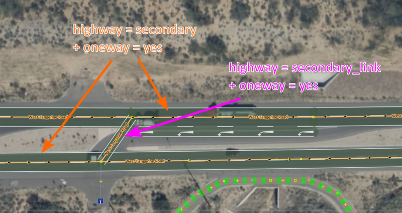
An example of a link in between two directions of a dual carriageway. Imagery used is Ersi. Screenshot of the iD editor from https://www.openstreetmap.org/#map=19/32.42391/-111.01031
Licensing
ISC
Screenshot of iD editor. It may contain different content with different licensing.
The iD editor software is published under ISC License – Copyright iD Contributors.
The iD editor software is published under ISC License – Copyright iD Contributors.
Permission to use, copy, modify, and/or distribute this software for any purpose with or without fee is hereby granted, provided that the above copyright notice and this permission notice appear in all copies.
THE SOFTWARE IS PROVIDED "AS IS" AND THE AUTHOR DISCLAIMS ALL WARRANTIES WITH REGARD TO THIS SOFTWARE INCLUDING ALL IMPLIED WARRANTIES OF MERCHANTABILITY AND FITNESS. IN NO EVENT SHALL THE AUTHOR BE LIABLE FOR ANY SPECIAL, DIRECT, INDIRECT, OR CONSEQUENTIAL DAMAGES OR ANY DAMAGES WHATSOEVER RESULTING FROM LOSS OF USE, DATA OR PROFITS, WHETHER IN AN ACTION OF CONTRACT, NEGLIGENCE OR OTHER TORTIOUS ACTION, ARISING OUT OF OR IN CONNECTION WITH THE USE OR PERFORMANCE OF THIS SOFTWARE.File history
Click on a date/time to view the file as it appeared at that time.
| Date/Time | Thumbnail | Dimensions | User | Comment | |
|---|---|---|---|---|---|
| current | 07:39, 28 March 2023 | | 1,204 × 638 (757 KB) | Mxdanger (talk | contribs) | Better example of a road that isn't currently under construction |
| 13:44, 18 November 2021 |  | 2,384 × 1,384 (4.55 MB) | Andygol (talk | contribs) | Update labels and arrows for better readability | |
| 22:04, 8 May 2021 |  | 1,091 × 632 (875 KB) | BubbaJuice (talk | contribs) | An example of a link in between two directions of a dual carriageway. Imagery used is Ersi. Screenshot of the iD editor from https://www.openstreetmap.org/#map=19/32.40770/-111.01289 |
You cannot overwrite this file.
File usage
The following 3 pages use this file: