File:Extension.png
Extension.png (756 × 310 pixels, file size: 20 KB, MIME type: image/png)
Summary
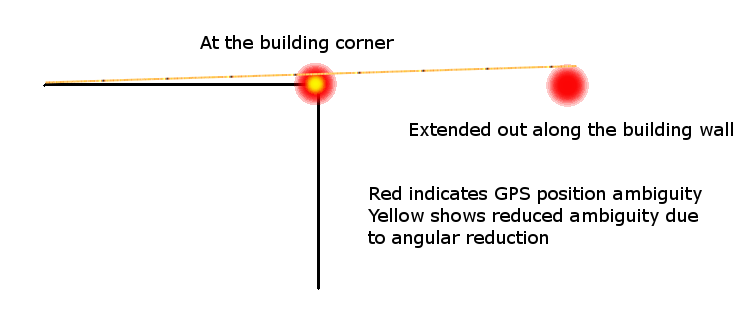
A visual depiction of how using a sight line along a building face can help to reduce the position ambiguity of a GPS unit. Standing close to a building blocks the GPS signal reception, degrading position accuracy even more than normal. Moving out away from the building gets a clear sky view, and that combined with the extended length of the wall can be used to reduce the error of the actual measured item. Draw lines between the extended points, and use them as guides to draw the actual building outline.
Licensing
![]()
![]()
![]()
Attribution not specified as a parameter! THIS LICENSE ALWAYS REQUIRES ATTRIBUTION! Use {{CC-BY-SA-2.0|Attribution, typically name of author}} See Template:CC-BY-SA-2.0 for full description how this template should be used.
Note, there is
{{CC-BY-SA-2.0 OpenStreetMap}} for files based on old OSM map data, before the license change made on 2012-09-12.There is also
{{OSM Carto screenshot||old_license}} for files based on old OSM map data, before the license change made on 2012-09-12, created using OSM Carto map style.
|
This file is using CC license which requires attribution, but it is not clearly specified. Uploader very often is also the author, but not always! If you created this work on your own and it is not derivative of some preexisting work, please use: {{CC-BY-SA-2.0-self}} to mark it as own work. If anyone else was involved please use: {{CC-BY-SA-2.0|1=WHOEVER SHOULD BE ATTRIBUTED}} Note: The file page should clearly state that either it is fully work of uploader or clearly specify which sources were used, preferably linking them. Note: Maybe this license is wrong and a different one should be used! Wiki:Media file license chart may be helpful. If unsure, ask on Talk:Wiki After fixing attribution – please remove this template. Files without licenses marked with this template are listed in Category:Media without a proper attribution |
File history
Click on a date/time to view the file as it appeared at that time.
| Date/Time | Thumbnail | Dimensions | User | Comment | |
|---|---|---|---|---|---|
| current | 16:05, 6 April 2013 | 756 × 310 (20 KB) | Ve6srv (talk | contribs) | A visual depiction of how using a sight line along a building face can help to reduce the position ambiguity of a GPS unit. Standing close to a building blocks the GPS signal reception, degrading position accuracy even more than normal. Moving out away... |
You cannot overwrite this file.
File usage
The following page uses this file: